Make the most of today and tomorrow
Victorian Forecast by Craig Brokensha (issued Monday September 9th)
Best Days: Today Surf Coast, tomorrow Surf Coast, Wednesday morning Surf Coast, Monday morning
Features of the Forecast (tl;dr)
- Moderate sized, inconsistent W/SW swell tomorrow with moderate NW winds, easing and tending W/SW-W to the east into the PM
- Easing swell Wed with fresh N/NW winds, shifting strong S/SW by midday
- Strong S/SW-SW winds Thu with a localised windswell
- Moderate sized W/SW groundswell building Fri PM, peaking Sat with W/NW tending fresh SW winds Fri, strong S/SW-S Sat
- Easing surf with mod-fresh S/SE winds Sun
- New, small-mod sized SW groundswell Mon with N/NW tending S winds
Recap
Various ebbs and pulses of W/SW swell have maintained surf generally in the 3-4ft range across the Surf Coast with great conditions both Saturday and Sunday. To the east options were limited and wind affected.
Today we’ve got our slightly bigger pulse of close-range W/SW swell mixed in with longer-range pulses and the Surf Coast is coming in at a good 4ft+ with offshore winds, larger to the east but bumpy. Winds will shift more W/NW into the afternoon and possibly W-W/SW later.
This week and weekend (Sep 10 - 15)
Today is the biggest of the week, with the three mix of swells expected to slowly taper off in size over the coming days.
In saying that, the long-range W/SW swell generated by a healthy fetch of strong to gale-force W/SW winds projecting towards and then under Western Australia is due to peak tomorrow.

This should maintain inconsistent 3-4ft sets across the Surf Coast magnets, 5-6ft to the east before easing back slowly Wednesday from 3ft and 4-5ft+ respectively.
A moderate NW’ly will create great conditions on the Surf Coast again tomorrow, easing but tending more W-W/SW to the east into the afternoon which isn’t ideal.
Wednesday will only be clean through the morning with fresh N/NW winds, shifting strong S/SW by midday as a trough moves through.
This trough will leave lingering, strong SW winds into Thursday along with some localised windswell.
Into Friday, winds will tip back to the W/NW for a period before reverting back to the SW along with a building, moderate sized W/SW tending SW groundswell that’s due to peak Saturday.

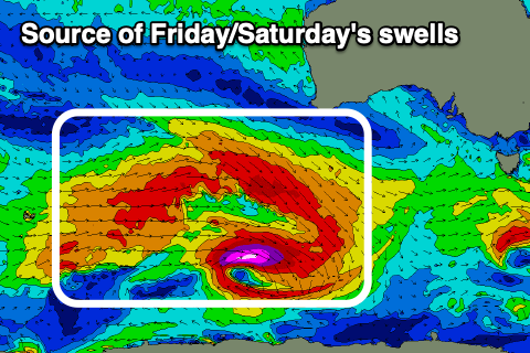
The source will be a broad, deepening polar low south-west of the country tomorrow evening with an initial prefrontal fetch of gale to severe-gale W/NW winds due to be followed by a broader, slightly weaker fetch of W/SW winds, better aimed through our swell window.
The prefrontal fetch should generate Friday afternoon’s building swell with the Surf Coast due to reach 3-4ft with 5-6ft sets to the east, while Saturday should come in a little stronger and to 3-5ft on the Surf Coast and 6ft+ to the east.
Unfortunately behind the swell generating low, a high will move in bringing strong S/SW-S winds on Saturday weaker but S/SE through Sunday as the swell eases. So all in all this swell looks to go to waste.
Smaller, reinforcing pulses of SW groundswell are due into early next week along with a more favourable N/NW offshore Monday, W/NW Tuesday but we’ll have a closer look at this Wednesday.


Comments
Looks like Laird Hamilton is out at Winki on his SUP, concerning viewing on the cam
Thanks for the update Tubba Bird. I’ve heard whispers that Laird has been up in Sydney all weekend, landing big Deals with a few core surf brands up there. Can you confirm?
Confirmed he’s trying to get his superfood creamer stocked into some surry hills brothels, jimmy deals working the case