Mixed period of surf with weak swells and tricky winds

Victorian Surf Forecast by Craig Brokensha (issued Wednesday 11th October)
Best Days: Today on the beaches, Friday and Saturday mornings Surf Coast, keen surfers Sunday morning Surf Coast, Wednesday on the beaches
Features of the Forecast (tl;dr)
- Easing swell into tomorrow with strong W/NW-W tending SW winds
- Late pulse of W/SW swells tomorrow, peaking Fri AM with W/NW tending W/SW winds
- Slight drop in size Sat AM ahead of some new swell later with W/NW tending W/SW winds
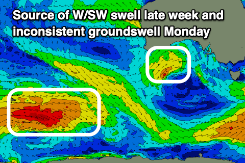
- Moderate + sized mid-period SW swell building Sun, peaking Mon AM, then easing
- Inconsistent SW groundswell also in the mix Mon
- Gusty but easing SW winds Sun (likely light W early Surf Coast), strong S winds Mon
- Light E winds with easing surf Tue, better Wed with local offshore winds (N/NE to the east, N/NW to the west) ahead of a S/SW change
Recap
Yesterday's reinforcing W/SW energy maintained 3-4ft sets on the Surf Coast and 5-6ft waves to the east and conditions were best west of Melbourne with variable offshore winds ahead of freshening sea breezes.
This morning the swell is on the ease and conditions are clean across all locations though strengthening N/NE winds will favour the beaches as the day progresses.

A day for the beaches
This week and weekend (Oct 12 - 15)
This afternoon's easing trend in size will continue into tomorrow morning, with the swell due to bottom out as winds strengthen from the W tending SW into the afternoon. The Surf Coast should see morning W/NW winds and 2ft sets.
The afternoon change will be linked to a mid-latitude front moving in from the west, with it dragging up a weak Southern Ocean front behind it into Friday.
The mid-latitude front is currently a low, sitting south of Western Australia, and this is generating a moderate sized, mid-period W/SW swell for Friday. There'll also be a mix of localised windswell from the front moving through with surf to 3ft+ due on the Surf Coast magnets and 5-6ft sets to the east.
Winds should shift back to the W/NW on Friday morning, tending W/SW through the afternoon and this will favour the Surf Coast. Lower your expectations with the weak nature of the swells though.
A temporary drop in size is due into Saturday morning, but the next flurry of frontal activity moving through Friday night should produce some reinforcing mid-period W/SW swell through the day, maintaining 3ft sets on the Surf Coast and 4-5ft+ waves to the east.
Morning W/NW winds will again favour the Surf Coast before shifting W/SW into the afternoon.
Moving into Sunday and Monday we've got a better mix of sizier, mid-period SW swell on the cards along with a long-range groundswell, though winds are a bit of an issue.
The polar front will project up from the south-west on Saturday while producing a healthy fetch, pushing further east on Sunday but leaving fresh but easing SW winds in its wake.
With the timing of the front being Saturday evening we may see winds tip back to the W for a period Sunday morning on the Surf Coast but don't count on it.
Size wise, the mid-period swell should be building from 3-4ft on the Surf Coast in the morning to 4-5ft into the afternoon, easing back from a similar size on Monday morning.
Also in the mix on Monday will be a long-range groundswell generated by a distant polar low that's currently generating a fetch of gale to severe-gale W'ly winds around the Heard Island region. The size from this low will be below that of the local energy.
Unfortunately conditions look poor Monday as high pushes in behind the front on Sunday, bringing strong S'ly winds that will ease off later in the evening.
Tuesday should be a little better for the beaches as winds shift light E but the size will still be solid and likely too big.
Wednesday looks a better bet with easing surf and morning offshore N'ly winds ahead of a trough and afternoon S/SW change.
Longer term a good SW groundswell is on the cards for later week but winds which looked to be favourable now look a little dicey. More on this Friday.