Fun beachy options mid-week ahead of tricky winds and swell from late week

Victorian Surf Forecast by Craig Brokensha (issued Monday 9th October)
Best Days: This morning Surf Coast, tomorrow morning, Wednesday exposed beaches, Friday morning protected spots, Saturday protected spots, next Tuesday through Thursday
Features of the Forecast (tl;dr)
- Easing SW groundswell this afternoon with a moderate sized, reinforcing mid-period W/SW swell tomorrow
- Variable tending S/SE winds tomorrow (light W/NW Surf Coast in the AM)
- Easing surf Wed with N/NE winds, strengthening from the NE through the day
- Low point in swell Thu AM with gusty W winds
- New mid-period W/SW swell and localised windswell building later Thu, peaking Fri AM with strong W/NW tending W/SW-SW winds
- Moderate sized W/SW swell building Sat PM (smaller in the AM) with gusty W/NW winds, shifting W/SW mid-late PM
- Mod-large mid-period SW swell building Sun with strong SW winds
- Easing surf Mon with strong S/SW winds
- Moderate sized, easing surf Tue with W/NW winds
Recap
Friday afternoon's large pulse of SW groundswell started to ease into Saturday but sets were still to 6ft or so on the Surf Coast through the morning, larger to the east but with lingering onshore winds. It wasn't great but there were options for the keen and experienced.
Lighter winds provided cleaner, more workable options to the east yesterday morning, more bumpy/lumpy to the west but this morning is the pick for the Surf Coast with a reinforcing groundswell to 3-4ft under a light W/NW breeze. Conditions aren't perfect but clean enough for a paddle and worth making the most of ahead of freshening S/SW winds this afternoon.

Fun surf this morning
This week and weekend (Oct 10 - 15)
The coming week of waves is fairly mixed with tricky winds though building levels of generally weak swell into the weekend and early next week.
This morning's SW groundswell is due to ease through the afternoon as winds freshen from the S/SW, while a reinforcing W/SW swell is due to hold wave heights up around 3ft on the Surf Coast and 4-5ft to the east.
Conditions look favourable through the morning and best to the west with a variable breeze that should tend light W/NW on the Surf Coast, while lumpy surf is likely to the east with variable S'ly winds.
Wednesday looks to be the pick for the exposed beaches with a N/NE offshore and easing swell from 2ft+ or so on the Surf Coast and 3-4ft to the east. Winds look favourable all day, strengthening from the NE but with weaker, smaller surf after lunch.
Thursday morning looks to be a low point in energy and pre-dawn, strong N'ly winds will shift W'ly around dawn, holding all day.
The change will be linked to a weak mid-latitude low that's currently south-west of Western Australia, moving in under the country this week.
The low will produce a small to moderate sized, mid-period W/SW swell for later Thursday but more so Friday, mixed in with local windswell as the remnants strengthening while moving across us Thursday/Friday.
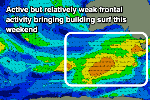
The Surf Coast should see 3-4ft surf on Friday morning with 6ft sets to the east. Strong W/NW-W winds will favour protected spots before shifting W/SW-SW through the afternoon.
Into the weekend, we'll see a flurry of late forming (in our swell window), strengthening mid-latitude and polar frontal activity. Back to back fetches of strong W/SW and SW winds should produce building levels of mid-period swell on the weekend and into early next week.
An initial increase in mid-period W/SW swell is due Saturday, building through the afternoon back to the 3-4ft range on the Surf Coast, with Sunday increasing further from a better SW direction, likely more towards 4-6ft later in the day but with deteriorating conditions. Gusty W/NW winds are due most of Saturday, shifting W/SW mid-late afternoon while Sunday looks poor under strong SW winds thanks to the larger swell generating front pushing through.
Behind the front a ridge of high pressure will move in, bringing unfavourable S/SW winds as the swell eases Monday, likely tending back to the W/NW on Tuesday with fun, easing surf from the 3-4ft range on the Surf Coast. Longer term, the rest of the week looks more positive with some decent S/SW groundswell on the cards along with favourable winds for the Surf Coast. More on this Wednesday.