Large swell spoilt by onshore winds

Victorian Surf Forecast by Craig Brokensha (issued Friday 6th October)
Best Days: Sunday for the keen, Monday morning Surf Coast, beaches Wednesday
Features of the Forecast (tl;dr)
- Large SW groundswell for this afternoon, easing tomorrow with mod-fresh S/SE winds early, tending moderate during the day
- Easing surf Sun ahead of a late increase in moderate sized S/SW groundswell
- Light-mod S winds Sun (variable across PI in the AM)
- Moderate sized mix of inconsistent SW groundswell and S/SW swell Mon with light-mod SW winds, freshening through the day (likely light W/NW Surf Coast in the AM)
- Mix of swells Tue with S/SW tending S/SE winds
- Easing surf Wed with N winds with weak sea breezes
Recap
The surf was raw but up in size yesterday with a mix of windswell and groundswell pushing to 4ft on the Surf Coast magnets, 6ft to the east but with onshore winds. The swell ironed out and organised itself through the day on the Surf Coast as winds held from the W/NW-W.
This morning conditions are average and deteriorating with early W/SW winds now swinging strong S/SW along with a mix of windswell and large, building SW groundswell (just pinged on the Point Nepean wave buoy).
The groundswell should build to the 6-8ft range across the Surf Coast later today and 8-10ft to the east as winds slowly ease but remain fresh from the S'th.
This weekend and next week (Oct 7 - 13)
There's no change to the wind outlook for the coming weekend, spoiling today's large, long-period SW groundswell as it eases.
This swell, generated by a 'bombing' low earlier in the week will peak this evening and ease through tomorrow though still come in at 6ft on the Surf Coast and 8ft to the east early.
The easing trend will be gradual and unfortunately a strong, stubborn high setting up camp immediately west of us will bring persistent, unfavourable S'ly winds.

A moderate to fresh S/SE breeze is due at dawn tomorrow, easing back to moderate through the day, while Sunday will see a further drop in size but with light to moderate, workable S'ly winds (variable across Phillip Island in the morning).
The Surf Coast looks to ease back from 3-4ft with 6ft sets to the east.
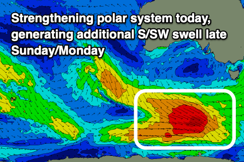
Moving into later Sunday but more so Monday, a fun reinforcing SW groundswell is due to peak, generated by a trailing front behind the low linked to today's swell. A distant fetch of gale to severe-gale W/NW winds around the Heard Island have generated this swell, with it since weakening, but it's due to re-intensify late in our swell window this afternoon (south-west of Tasmania), adding some additional S/SW energy to the mix.
The Surf Coast should perk back up to 3-4ft later Sunday and Monday morning with 5-6ft sets to the east, easing into the afternoon.
Winds look to remain a PITA with a light to moderate SW'ly Monday morning, freshening through the day. The Surf Coast will likely see light, early W/NW winds, creating cleaner conditions.
Into Tuesday S/SW tending S/SE winds will persist along with a final pulse of swell. That being some mid-period W/SW energy and this looks to maintain 3ft waves on the Surf Coast and 4-6ft sets to the east before easing Wednesday from 2ftto possibly 3ft and 4ft+ respectively.
Winds should finally swing to the N'th on Wednesday, opening up options across the more exposed beaches.
Longer term, a strengthening pair of mid-latitude and polar systems should bring an increase in windy swell late next week and into the following weekend/following week. The details are vague so check back here on Monday for the latest. Have a great weekend!
Comments
On shore winds be gone !
The elongated High in the Bight, same thing happened this time last year. Hopefully not until December again this year.