Easing surf with strengthening winds, more action from the weekend

Victorian Surf Forecast by Craig Brokensha (issued Wednesday 26th April)
Best Days: Today, Saturday, Sunday, Tuesday Surf Coast, Wednesday morning Surf Coast
Features of the Forecast (tl;dr)
- Small, easing surf tomorrow with strong N/NE winds, easing and then picking up again through the PM (tending N/NW to the west)
- Inconsistent, building SW groundswell Fri PM with strong NW winds ahead of a SW change around midday
- Mix of moderate sized close-range SW swell and long-range SW groundswell with early W/NW tending moderate S/SW winds mid-AM
- Easing surf Sun with local offshore winds ahead of weak sea breezes
- Late increase in SW groundswell Mon, peaking Tue
- E/SE winds Mon, N/NW tending W Tue
- Moderate sized SW swell for Wed with strong W/NW tending W/SW winds
- More swell likely Thu onwards
Recap
Another great day of surf across both regions yesterday with a temporary low point in swell through the morning ahead of a good, new pulse of W/SW groundswell that peaked into the afternoon. The size was a touch above expectations with 4ft sets reported on the Surf Coast and 6ft+ waves to the east.
This morning the swell has dropped but conditions are again good for both regions with 2-3ft sets to the west, 3-5ft to the east. The swell will ease all day as winds hold out of the N/NE, favouring the exposed beaches.


Great conditions and solid sets to the east yesterday arvo
This week and weekend (Apr 27 - 30)
After the great run of surf seen through the last few days, tomorrow will become less appealing thanks to the swell bottoming out under a stronger N/NE breeze that will east temporarily later morning before increasing again through the afternoon, tending N/NW to the west.
Size wise the Surf Coast looks to fade from 1-2ft with 2ft to possibly 3ft sets to the east.
On Friday and Saturday, two seperate pulses of inconsistent SW groundswell are due to fill in, generated by pre-frontal and post-frontal fetches of gale-force winds on either side of a polar low that developed around the Heard Island region earlier this week.
The first pulse should fill in Friday, building to an inconsistent 3ft later in the afternoon/evening on the Surf Coast magnets, with 4-5ft sets to the east. The morning looks smaller and to 2ft and 3ft respectively. Winds will become strong from the NW on Friday morning ahead of a weakening frontal system pushing in from the west, shifting SW around midday, spoiling the new swell for the afternoon.
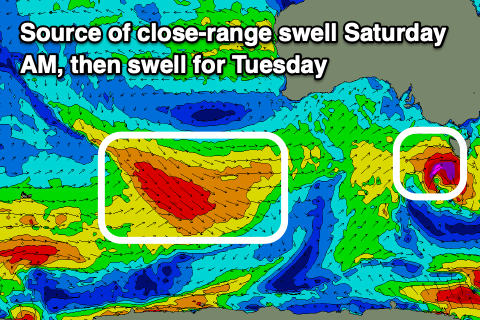
Unfortunately this front looks much weaker, with a tight, brief burst of W/SW gales due to be generated just west of Bass Strait during Friday. This looks to generate a more consistent 3ft wave on Saturday across the Surf Coast, 4-6ft to the east, mixed in with the secondary long-range groundswell. The long-range energy should provide the odd bigger but very inconsistent set on the Surf Coast magnets and winds will be W/NW early before shifting S/SW-SW mid-morning though only moderate in strength.
Sunday will see the swell easing in size along with variable, local offshore winds ahead of weak sea breezes.
Moving into next week, and Monday looks a touch dicey thanks to a trough sitting to our north-east, possibly bringing E/SE winds along with a building SW groundswell event.
The prolonged event will form as a frontal system swinging in from the south-east Indian Ocean, develops into a low south of Western Australia before moving slowly east.

The initial front will generate a great fetch of W/NW gales and a building swell later Monday that should peak Tuesday morning to 3ft to occasionally 4ft on the Surf Coast magnets and 5-6ft to the east. A secondary pulse of mid-period SW swell is due Wednesday produced by strong to gale-force W/SW winds, coming in at a similar size.
Winds look favourable Tuesday morning and N/NW, shifting W into the afternoon, with stronger W/NW tending W/SW winds on Wednesday. The strengthening winds will be ahead of a mid-latitude front that looks to bring a further increase in swell through Thursday but we'll have a closer look at this on Friday.
Comments
Just hope that consistency hangs round.
A touch above? 8 foot solid sets with a long period sure was.
Totally - When I arrived at Bells yesterday arvo - I saw 5 ft sets rolling through - for a split second I thought nobody was out, then I realised the entire pack was caught inside.
Yeah mental, heard they were only a couple of those? Mostly 6ft?
Yep there were a couple of 6ft sets then it tapered off really quick and went quiet for an hour. Depending on when people checked in the afternoon you'd have heard 4-6 or 2-4.
A simply beautiful combo of waves, weather and clear water the last week. This morning with barely anyone out was the cherry on top. I'm cooked and very content. On ya Craigos
YeH cheers for the waves Craigos- you’re the man