Rapid rise in large swell expected today

Victorian Surf Forecast by Craig Brokensha (issued Monday December 26th)
Best Days: Selected spots for the experienced this afternoon, tomorrow, dawn Wednesday Surf Coast, Friday morning all locations
Features of the Forecast (tl;dr)
- Large W/SW groundswell building rapidly this afternoon with freshening S/SW winds
- Mod-large swell easing steadily Tue with NE tending fresh E/NE-NE winds into the PM
- Smaller Wed with strong pre-dawn N winds, shifting W/NW at dawn ahead of a strong mid-morning SW change
- Weak W/SW windswell Thu with fresh S/SE winds
- Inconsistent mid-period W/SW swell Fri with variable tending S/SW winds
- Easing surf Sat with S tending S/SW winds
Recap
Great surf and options all over for the Christmas weekend with clean conditions on the Surf Coast Saturday morning with inconsistent 3ft sets on the magnets, better on the beaches yesterday morning with a new mid-period swell and favourable winds for most locations.
The swell peaked into the afternoon with a few biggers sets in the mix, but with sea breezes.
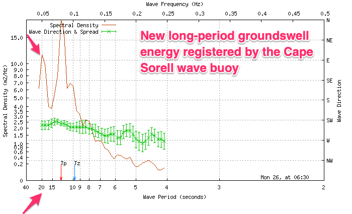
This morning we’ve got a temporary low point ahead of a large, rapid increase in W/SW groundswell that’s just hit the Cape Sorell wave buoy. Expect it to arrive mid-late morning and build set by set to 6-8ft on the Surf Coast through the afternoon and 10ft+ to the east but with a freshening S/SW breeze.
This week and weekend (Dec 27 - Jan 1)
The coming week revolves mostly around this afternoon’s large pulse of W/SW groundswell, generated by a ‘bombing’ low that formed to the south-west of Western Australia last Friday. Satellite observations picked up an incredible fetch of storm-force winds (below left), and observations from Western Australia confirm we’re looking at step-ladder sets and a rapid increase in size as the swell builds through today.

As touched on above, the Surf Coast magnets should reach 6-8ft later this afternoon/evening with 10ft+ sets across exposed breaks to the east but with a freshening S/SW breeze. Not ideal but workable.
The swell peak will be fairly short-lived due to the quick east, then south-eastward track of the low, with tomorrow expected to see steadily easing sets from 4-5ft+ on the Surf Coast at dawn and 6-8ft to the east.
Winds will be favourable for locations to the east and out of the NE through the morning, possibly holding into the afternoon and freshening from the E/NE-NE as a weakening mid-latitude low pushes in from the west. This will create more options into the afternoon and evening as the swell drops and becomes more accessible.
Our change on Wednesday has unfortunately been brought forward, with pre-dawn, strong N winds due to swing W/NW around dawn and then strong SW by mid-morning. There won’t be much size left with easing 2-3ft waves on the Surf Coast and 4ft+ waves to the east.
Now, with the quicker movement of the weakening low pushing east over the coming days, we’ve got a downgrade in the swell expectations from this system.
An initial healthy fetch of strong W/SW winds projecting up towards Western Australia will generate some small, inconsistent mid-period W/SW swell for Friday, but ahead of this on Wednesday afternoon and Thursday, we’ll see some weak windswell.
The Surf Coast should come in around 2-3ft with 4ft+ sets to the east Thursday but with fresh S/SE winds following Wednesday’s change, better Friday and variable (likely locally offshore) before another trough brings a S/SW change through the afternoon. The inconsistent mid-period energy looks smaller with 2ft+ waves on the Surf Coast and 3-4ft sets to the east.
Looking longer term and the trough will spoil conditions into the weekend with lingering S/SW breezes due both Saturday and Sunday. Swell wise, some small inconsistent mid-period energy is due with next week due to consistent of poor south-east winds and no major size. Therefore make the most of the coming swell!
Comments
Looks about 4 maybe odd 5 footer on the reefs now. Unfortunately a Dirty onshore now in.
Mate surfed the reefs and was 3-4ft+ but then they all got smoked by a 6ft bomb set. This was around 7:30am.
Comming through strongly now, 5.74 max spike just before the buoy went offline at 12.30.
Have fun crew. Slightly jelly to read the forecast from somewhere smaller, with much warmer water...
Lines look soo thick and strong.
There were 2 out at Bells giving it a real good crack this arvo. Good on ‘em
Any one at Winki?
What size do you think at Bells?
Not a soul. Looked like the sweep would have ruined anyones efforts out there.
Bells would have been 6-8ft for the halfa I watched. Lot of water moving around.
Got some footage of that. Sunset was a cracker to boot.
Magic. Thanks.
Bells - D.S. size
7'6" +
And the Lorne Pt Cam....Picturesque day
A friend and myself just got in from one of the only places that handles these swells and s.e winds on the MP and it was probably the biggest and thickest I’ve seen it from memory.
Only a couple of the smaller ones were breaking along the reef properly though the majority of them were too wide and missing the mark.
Think a reverse bells type deal.
No one else in the water, pretty exciting even though the waves weren’t great.
Great work GF! Yeah interesting to see how some spots, while they need the size or period to get working, would actually be better with less walled up lines and a lesser period swell. So they don't run off fat and wide.
Too much of a good thing craigos.
I would hate to think how big it is past Cape Otway :-0
Have to be nearly 20ft sets ?
Yep!
Top stuff GF. I was wondering how that spot would be.
Shutting down or just breaking really wide?
Really wide and shutting down not long after
Checked my local on dark, biggest I've seen it since moving down here. Super low tide made it all the more impressive.
Hey Craig is it possible to see the wind charts for the 13th of November this year. Either a view like windy or BOM produce
Is this helpful? Forecast done on the 14th of November..
https://www.swellnet.com/reports/forecaster-notes/victoria/2022/11/14/bu...
Wonder if the Sydney to Hobart fleet will run into some of this swell and associated weather as they head south. Must be daunting knowing it's lurking down there.
The swell is on the steady decline but they'll definitely be seeing some swell once they head further down the Tasmanian coast. Easy going on those yachts though with the large wave-length.
Cheers Craig. Yeah looks like they'll run into a bit of weather just as they round the bottom of Tassie, especially the slower smaller yachts.
Can't help but feel a little nervous for the rest of the fleet coming down and rounding the Southern tip of Tassie tonight. Sounds like it's gonna get real. God speed crew.
https://www.sail-world.com/news/243861/Roger-Clouds-Badham-ETNZs-forecaster
3 drownings here since Christmas.
Good reminder to keep an eye out for people that don’t know what they’re doing. Particularly at this time of year. Seems to be a common theme that the people that get in in trouble either can’t swim or get in strife being in conditions well beyond what they can handle.