Building, windy surf, improving later week

Victorian Surf Forecast by Craig Brokensha (issued Monday 14th November)
Best Days: This morning on the Surf Coast ahead of the change, protected spots for the keen and experienced tomorrow morning and Wednesday morning Surf Coast, exposed beaches Friday morning and more so Saturday
Features of the Forecast (tl;dr)
- Moderate sized mid-period SW swell building today with a strong SW change due late morning/midday
- Moderate sized + S-S/SW swell building tomorrow with strong SW winds (possibly W'ly for a period around Torquay tomorrow AM)
- Easing swell Wed with gusty SW winds (W'ly for a period around Torquay in the AM)
- Smaller Thu AM ahead of a moderate sized SW groundswell into the PM, holding Fri AM, with a reinforcing mid-period swell for later in the PM, easing Sat AM
- Mod-fresh S/SW winds Thu, easing and tending more S
- E/NE tending SE winds Fri
- Strengthening N/NE winds Sat
- Low point in swell Sun with increasing W/NW tending W/SW winds
Recap
Bumpy surf on Saturday with lingering onshore winds following Friday's change and easing surf. The Surf Coast was average and 2-3ft with 4-5ft sets to the east.
Sunday was smaller and weaker with a E/SE windswell offering a few novelty options on the Surf Coast as winds swung offshore. This was generated by a brief fetch of strong E winds through Bass Strait Saturday evening and early Sunday morning. To the east it was a weak 2ft with the cleanest conditions found early.
Today it looks like our new SW swell due later today has arrived a little earlier with a kick to 3ft on the Surf Coast magnets under a fresh offshore wind. A strong SW change is due late morning so surf now.
This week and weekend (Nov 15 - 20)
Today's change will be linked to a strong and destructive mid-latitude low that's impacted both South Australia and our state, continuing east, with us falling under onshore winds on its western flank.
It'll also draw up a polar front come strong low, with a fetch of strong to near gale-force S'ly winds now expected to be projected through our southern swell window.
This will generate a moderate sized + S-S/SW swell for tomorrow, peaking into the afternoon, then easing Wednesday as the low continues slowly east.
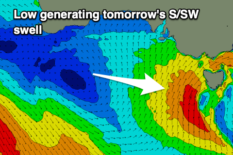 This swell will be mixed in with today's, building mid-period SW swell and we should see 3-4ft waves tomorrow morning, kicking further to 5ft or so during the afternoon on the Surf Coast. The exposed beaches to the east are due to build to 6ft+ but with strong SW winds. There's a chance that winds tend W'ly for a period on the Surf Coast tomorrow morning, but conditions will still be raw and all over the place.
The swells will ease through Wednesday back from the 3-4ft range on the Surf Coast and 5ft to the east as winds persist from the SW, fresh in nature. Again the Surf Coast will likely see a period of early W'ly winds but lower your expectations.
The end of the week isn't overly special for the Surf Coast as the strong low linked to our sizey S/SW swell stalls on its way east, resulting in moderate to fresh S/SW tending weaker S winds on Thursday.
Conditions will finally clean up into Friday as winds swing back around to the E/NE along with two fun new pulses of SW swell.
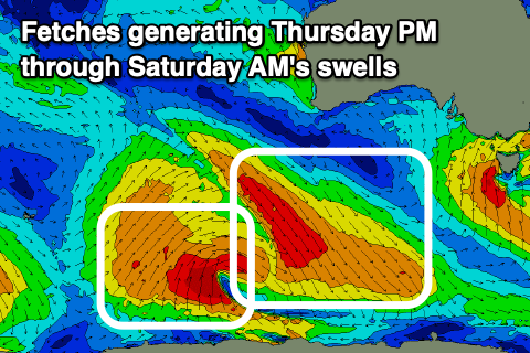 As touched on last week, this will be generated by a strong but poorly structured low firing up to the south-west of Western Australia. We're interested in both the north-eastern and south-western flank of the low. The north-west fetches will generate an increase in size Thursday afternoon and Friday morning, with the south-western fetch, later Friday and Saturday morning.
Both pulses look to be in the 3ft range across the Surf Coast and 4-5ft to the east.
Friday morning might be a little lumpy still with the light E/NE offshore, with Saturday seeing great conditions under a slowly strengthening N/NE-NE offshore that will hold all day.
Sunday looks average as the swell reaches a low point as a strong approaching cold front brings a strengthening W'ly wind.
Into next week this cold front will strengthen on approach to us, bringing a close-range but sizey W/SW-SW swell for early next week along with strong winds out of the south-western quadrant. We'll look at this in more detail over the coming updates.