Active period of moderate sized swell

Victorian Surf Forecast by Craig Brokensha (issued Monday 31st October)
Best Days: Tomorrow morning Surf Coast, later Wednesday Surf Coast, Friday Surf Coast, Sunday morning, beaches early-mid next week
Features of the Forecast (tl;dr)
- Slow, building mid-period W/SW swell tomorrow with fresh W/NW-NW winds ahead of a SW change early PM, stronger later
- Moderate sized S/SW swell for Wed, peaking in the PM with gusty W/SW winds (possibly W/NW early Surf Coast), shifting W/NW later PM
- Moderate sized SW swell for Thu, easing slowly Fri
- Gusty SW winds Thu (small chance W'ly Surf Coast early)
- W/NW tending S/SW-S winds Fri (Surf Coast) SW tending S/SW-S elsewhere
- Inconsistent SW groundswell Fri PM, easing Sat with E/NE tending S/SE winds
- Inconsistent SW groundswell Sun AM with local offshore tending S/SE winds
- Easing swell Mon with S/SE winds
Recap
A bit of swell on Saturday with peaky, lumpy conditions best suited to the Surf Coast and in the 3ft range, smaller into Sunday and best across the beaches as early funky winds swung more offshore, ironing out conditions into the afternoon.
This morning the swell is reaching a low point, wind affected and choppy to the east, clean but tiny on the Surf Coast.
This week and weekend (Nov 1 - 6)
We've got a complex week of weather and surf ahead thanks to a strong, unseasonal cold outbreak pushing up and across the country from Western Australia.
We're seeing winds increase today ahead of the incoming cold air, with the front proper due to move across us tomorrow through Wednesday bringing low level snow and terrible weather for the Melbourne Cup.
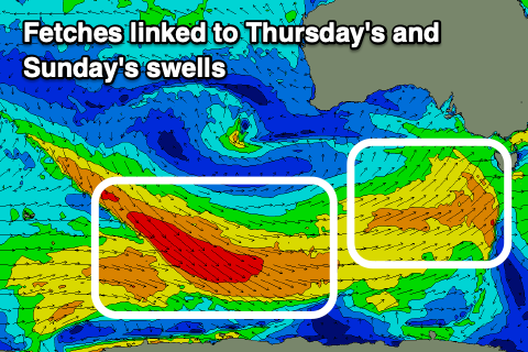
Swell potential wise we're looking at mostly mid-period energy thanks to the winds behind the slow moving frontal progression not reaching the gale-force range and down on Ben's early outlook last week. In saying this the back to back nature of frontal activity through our south-western and southern swell windows will produce moderate levels of swell from Thursday through Saturday.
 There'll also be some localised S/SW swell energy on Wednesday from a fetch of slow moving S/SW winds projecting in from the west tomorrow.
So looking at the expected sizes, and tomorrow looks to be on the small side of the coin with a mix of weak swells slowly building under a fresh W/NW-NW breeze ahead of an early afternoon SW change, strengthening into the evening.
Expect waves to 2-3ft on the Surf Coast and 4ft+ to the east building a little more into the afternoon but with those poor onshore winds.
Wednesday should see more size with the mid-period S/SW swell coming in 3ft to occasionally 4ft on the Surf Coast and 5ft+ to the east. Winds aren't too ideal in the morning and will be generally gusty from the W/SW (likely W/NW early Surf Coast), but an approaching front should tip winds more W/NW later afternoon and into the evening.
This looks to be the time to surf with more convincing 4ft sets on the Surf Coast out of the wind.
 Come Thursday, our first pulse of mid-period SW swell should fill in, providing consistent 4ft sets on the Surf Coast magnets (3-4ft elsewhere) and 6ft sets to the east. Conditions will be average though with gusty SW winds, possibly tending W'ly for a short period early morning on the Surf Coast but still raw.
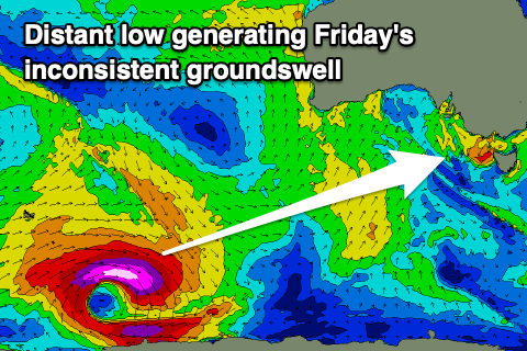
A slight drop in size is expected on Friday back to 3-4ft on the Surf Coast, though a distant SW groundswell should provide more punch to the sets, generated by a strong polar low that's developed east of the Heard Island region yesterday. Winds were strong but brief, reaching severe-gale to storm-force on the polar shelf.
This groundswell energy is likely to peak through the afternoon Friday and winds should slacken, with a light W/NW breeze due on the Surf Coast, SW elsewhere and tending S/SW-S across all locations into the afternoon.
Easing surf with lighter winds out of the E/NE are due on Saturday though the beaches might still be a bit chunky in the morning, more accessible into the afternoon but with sea breezes.
Later in the day a new inconsistent SW groundswell is due, peaking Sunday morning, generated by a great fetch of NW gales swinging in from the Indian Ocean behind the polar low mentioned just above. EC has this a little weaker than GFS so we'll have to have another look at the system on Wednesday and Friday.
Size wise we should see 3-4ft sets on the Surf Coast with 6ft waves to the east and winds will shift locally offshore (N/NW Surf Coast and N/NE beaches) ahead of S/SE sea breezes.
The size should ease back through early to mid next week, with possibly dicey S/SE winds on Monday, swinging back to the NE through Tuesday and Wednesday, but we'll have a closer look at this and Sunday's swell on Wednesday.
Comments
Not good enough. Ben promised..
least we get the forecast early once Craig's back
Props to the surf reporter this flat morning "No surf for you!"
ah memes
For a November forecast, not too bad all things considered.
Yep. I'm happy with it. Lots to work with. Cheers.
Not complaining, love it!
Friday, North side at The Island : It looks better than nothing.
amazing forecast! any reason that kick in swell for sunday is not showing on the charts?
Wrong notes? This was published Monday. Latest is here:
https://www.swellnet.com/reports/forecaster-notes/victoria/2022/11/04/ex...