Good surfing options next week

Victorian Surf Forecast by Craig Brokensha (issued Friday 19th August)
Best Days: Sunday, Tuesday morning Surf Coast, Wednesday Surf Coast, Friday, next Saturday and Sunday
Features of the Forecast (tl;dr)
- Easing mid-period W/SW swell tomorrow with strong SW-S/SW winds arriving at dawn, abating through the day
- Inconsistent mid-period W/SW swell Sun AM with N/NW winds, strengthening from the NW through the day
- Smaller Mon with strong N/NW tending W/NW winds, shifting W/SW late in the day
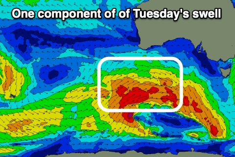
- Moderate sized SW swell for Tue, biggest Wed, easing Thu
- Fresh W/NW winds Tue AM, W/SW into the PM
- Mod-fresh W/NW winds Wed, strong SW winds on Thu
- Moderate sized mid-period S/SW swell Fri with variable tending SE winds
- Reinforcing S/SW swell next weekend with morning N winds and weak sea breezes
Recap
The swell reached a low point yesterday as winds strengthened from the N'th, shifting more NW into the afternoon and evening.
Today we've got a weak increase in low-period W/SW swell ahead of our mid-period W/SW swell this afternoon (it hit Cape Sorell at 6:30am) with clean conditions in protected spots on the Surf Coast, choppy and poor to the east. We should see the Surf Coast reaching 3ft on the sets across the magnets later afternoon as winds hold from the W/NW.
This weekend and next week (Aug 20 - 26)
The weekend will be a little slow and tricky, as a cold front linked to a reinforcing pulse of mid-period W/SW swell for Sunday clips us on dawn tomorrow, bringing a strong SW-S/SW change, abating into the afternoon.
This afternoon's swell will ease in size from 2-3ft on the Surf Coast and 4-5ft to the east but conditions will be poor.
Winds and conditions will improve considerably into Sunday as winds shift back to the N/NW, strengthening into the afternoon and shifting NW. Swell wise, an inconsistent mid-period W/SW swell should maintain 2-3ft sets on the Surf Coast magnets and 4-5ft waves to the east, generated by a distant fetch of strong W/NW winds swinging in from the Indian Ocean, weakening when pushing through the Bight.
This swell is due to ease into the afternoon with a low point expected Monday morning, as winds strengthen from the N/NW, shifting W/NW through the day ahead of a late W/SW change.
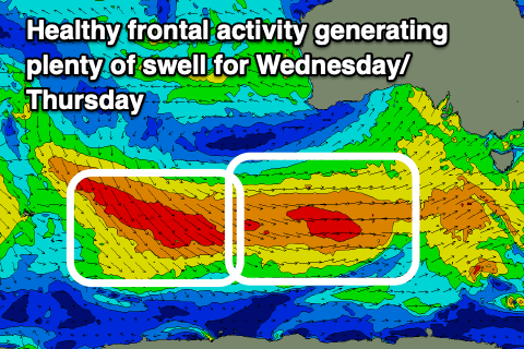
This change will be linked to a broad, Southern Ocean frontal progression moving in from the south-west, with the structure and strength changing a little from earlier in the week.
 An initial polar low now looks weaker but the follow up frontal activity behind it is broader and a little better.
All in all there's no major strength to the fetches of strong to near-gale-force W/SW-SW winds moving through our south-western swell window, with various pulses of moderate sized mid-period SW swell due from Tuesday through Friday, with follow up pulses arriving from the S/SW into next weekend.
The first pulse of mid-period SW swell for Tuesday looks to come in around the 4ft range on the Surf Coast, 6ft to the east, with Wednesday seeing the most size, coming in at 4-5ft and 6-8ft respectively.
 Winds look best for protected spots and W/NW Tuesday morning, shifting W/SW after lunch, with Wednesday looking the pick under moderate to fresh W/NW winds, persisting all day.
A slight easing trend is due on Thursday and winds look to shift SW in the wake of all the activity pushing through during the week.
Come Friday, a good pulse of S/SW energy is due, generated by a polar fetch of strong to gale-force W/SW winds to the south-west of Tasmania Wednesday, and this should build back to 4-5ft into the afternoon on the Surf Coast and 6ft to possibly 8ft to the east as winds become variable, likely tending locally offshore ahead of a weak SE'ly into the afternoon.
More favourable N'ly winds are due with moderate sized, slowly easing pulses of S/SW swell next weekend before then entering another quiet period. So make the most of the coming swell on the Surf Coast next week! Have a great weekend.
Comments
Alhamdulillah!
Waaaahhhhooooo!
Great! Now I'll just have to re-learn what it's like surfing waves over 2ft.....
Never thought I'd see that headline again
I'll need to see it to believe it.
Are you sure this report is for Vicco Craig?
Must being confusing NSW...
But I just sold all my boards in an end of era SALE
Fucken ay.
Waves? What are they ?
My wet suits and boards have not seen action since May !
The quiv is waxed and ready to rumble
Now all I need to do is work out what to do with a newborn
Any baby sitters out there located in the bells winki carpark?
The core process takes about 20 years, give or take.
Congrats :)
Thanks VJ, day 0-12 has gone pretty well
Only 7292 days to go give or take :)
Imagine the crowds on the west coast this week :-0