Small workable waves from Friday

Victorian Surf Forecast by Craig Brokensha (issued Wednesday 13th July)
Best Days: Friday (spots to the east late), Saturday, Sunday morning Surf Coast
Features of the Forecast (tl;dr)
- Easing mix of swells tomorrow with light W/NW tending variable winds on the Surf Coast (mod S/SW-S but easing to the east)
- Inconsistent mix of W/SW and SW swell Fri with moderate W/NW tending variable N/NW winds later
- Better SW swell arriving mid-morning Sat with strong N winds
- Easing SW swell Sun with strong NW winds ahead of a PM SW change
- Smaller next week as winds shift more NE
Recap
Clean conditions on the Surf Coast with a small lift in swell to 1-2ft yesterday morning, a touch bigger into the afternoon but with average conditions.
Today the surf is a choppy mess in the wake of yesterday's change and there's nothing to recommend at all.
This week and weekend (Jul 14 - 17)
Looking at the outlook for the end of the week and we've got generally small surf but with cleaner conditions.
We'll see the mix of swells seen in the water today easing back through tomorrow from 2ft on the sets across the Surf Coast and 3-4ft on the Mornington Peninsula/Phillip Island.
Conditions will be best on the Surf Coast as winds revert back to the W/NW tomorrow morning, moderate S/SW-S to the east and variable into the afternoon.
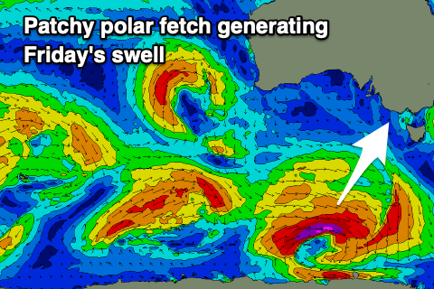 Our new mix of W/SW and SW swells for Friday looks a little dicey. The source of these swells was an initial mid-latitude front, generating mid-period W/SW swell energy, dipping south-east while strengthening at polar latitudes. This later strengthening stage was expected to generate the best SW energy, but the fast movement and patchy fetches of strong to gale-force W-W/NW winds doesn't look ideal at all.
I'd lower the expectations from this source but we'll hopefully see 2ft to occasionally 3ft sets on the Surf Coast magnets through the day Friday with surf in the 4ft range to the east.
The Surf Coast will be cleanest again with a moderate W/NW-NW offshore wind, tending variable N/NW into the afternoon. This might offer a few better waves later to the east so keep an eye on things.
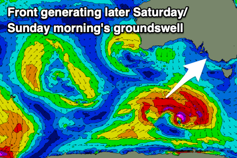
Moving into the weekend, Friday's swell will ease temporarily into Saturday morning ahead of a new pulse of mid-period SW swell through the afternoon.
This looks a little more reliable with it generated by a short-lived polar front, produced by a fetch of strong to gale-force W/SW winds through our swell window tomorrow.
2-3ft surf should be seen across the Surf Coast from mid-morning, 4-5ft to the east and with strengthening N'ly winds ahead of an approaching trough from the west.
 Sunday morning should see similar sized surf, easing through the day along with strong NW winds ahead of an afternoon SW change.
Behind Sunday's change, a strong and broad high is due to move in, blocking our main swell windows resulting in a small run of S/SW energy through next week. Winds will swing back offshore from Tuesday on the beaches, similar Wednesday but we'll be looking at 2-3ft leftovers on the exposed beaches.
Longer term there's still nothing major on the cards so try and make the most of the coming smaller swells.
Comments
"Longer term there's still nothing major on the cards so try and make the most of moving to New South Wales."
FIFY
what's the super moon scenario do for a morning surf tomorrow Bells area ? any takers ..?...low tide 5.40 ish ,,,I guess super low,,,but fills in fast till 1pm ish ..and super high...