Indonesia/Maldives forecast Jun 17

Indian Ocean Basin analysis by Craig Brokensha (issued Tuesday 17th June)
This week through next (Jun 18 - 27)
Following the swell later last week, a good new SW groundswell filled in yesterday, with a dropping trend expected through today.
A flukier but strong pulse of S/SW groundswell is then due later today, generated by a strong low that formed south-west of Western Australia last Friday. This low generated fetches of severe-gale to storm-force W/SW winds late in our southern swell window, with it coming in oversized across Western Australia.
We should see a moderate to large kick in size later today, peaking overnight before easing steadily through tomorrow. Locations further east will likely miss the bulk of the swell, similar across north Sumatra.

The next increase in size is due Friday, with a mix of large SW groundswells due to fill in, with the best being generated by a tight low that spawned off a broader frontal progression Sunday.
This low generated a short-lived fetch of tight, severe-gale to storm-force winds while tracking east-northeast, with the swell due to arrive Friday morning, building towards a peak later in the day.
It looks large in size, with a general easing trend due into Saturday.
A larger but slightly less consistent SW groundswell is then due into Sunday, produced by a broader, more expansive polar frontal progression that formed in the Southern Ocean over the weekend.
Various fetches of gale to severe-gale W/SW winds were generated, continuing into this morning, with a final burst of severe-gale W/SW winds being generated east of the Heard Island region today.
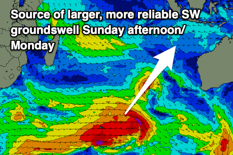
This should produce large surf into Sunday afternoon, easing Monday.
This easing trend will be slowed by moderate to large levels of mid-period S/SW in the mix Monday, generated by a strong but weakening polar front pushing up and along the Western Australian coast Friday/Saturday.
This will then feed into a strengthening high to the west of Western Australia, producing a robust fetch of SE trades for the Maldives (discussed in more detail below). Otherwise, some new, large SW groundswell is due later week, produced by a strong frontal progression forming under South Africa tomorrow, pushing slowly east through the end of the week.
Following this a stronger, northward located low may generate a larger SW groundswell for next weekend, but we'll confirm this Thursday.
Our easing trades are expected from tomorrow, tending more S/SE-SE into the afternoons, before strengthening again from Sunday through early next week. Each morning, light, local offshore winds are due.

In the Mentawais, the strong, tight low should generate large surf out of the S/SW later Thursday but more so Friday, easing into the weekend ahead of the longer-range S/SW groundswell later Sunday/Monday.
The strengthening SE trades into the weekend will also add moderate levels of S/SE trade-swell to the mix early next week.
The groundswell for later in the week is more so Wednesday afternoon/Thursday and local winds are due to remain variable, possibly shifting SE across southern locations later next week.
----------------------------------------------
Maldives:
Easing levels of SE trade-swell are being seen across the central atolls with south swell also abating across southern locations.
We’ve got a very active outlook from tomorrow through next week though as firstly S/SW groundswells impact the southern atolls.
An initial pulse of S’ly groundswell from a strong frontal progression firing up to the south-east of Madagascar is due later tomorrow, peaking Thursday to a large size across the southern atolls.
We’ve then got the groundswell from the broad, expansive fetch of gale to severe-gale W/SW winds across the polar shelf due later Saturday, peaking Sunday. This swell looks similar in size to Thursday’s but a little less consistent.
Another slightly smaller but good pulse of S/SW groundswell is then due Tuesday, produced by the frontal system firing up under South Africa tomorrow, with a following, northward protruding low likely generating larger surf later next week.
Trade-swell wise and a weak fetch of E/SE trades firing up south of us today should generate small-moderate levels of S/SE trade-swell for later this week and Saturday morning, easing thereafter.
Of greater significance is the broad, strong fetch of SE trades setting up south-west of Indonesia over the weekend, generating moderate to large levels of SE trade-swell for mid-late next week.
Local winds look much better this period, weaker and out of the W-W/SW across northern and central locations with more variable winds to the south.
Winds might tend more SW through next week across northern and central locations, S-S/SE in the south.
Eastern Indonesia:
Moderate to large, acute S’ly groundswell for later today to 6ft to possibly 8ft across exposed breaks, easing tomorrow from a slightly smaller size.
Large mix of SW groundswells building Friday to 6-8ft across exposed breaks, easing Saturday.
Larger, less consistent SW groundswell building Sunday, reaching 8ft across exposed breaks into the afternoon, holding Monday morning.
Reinforcing mod-large mid-period S/SW swell for Monday, easing Tuesday.
Inconsistent, moderate to large SW groundswell building later Wednesday, peaking Thursday to 6ft+ across exposed breaks.
Larger SW groundswell likely next weekend.
Weakening SE-S/SE trades over the coming days, strengthening from the E/SE from Sunday into early next week. Light, local offshore winds each morning.
Uluwatu 16-day Forecast Graph/WAMs
Western Indonesia/Mentawais/South Sumatra:
Moderate sized S’ly groundswell for later today/tomorrow to 4-5ft across exposed breaks.
Large SW groundswell building later Thursday, peaking Friday to 6-8ft across exposed breaks, easing Saturday.
Large, less consistent S/SW groundswell building Sunday afternoon to 8ft across exposed breaks, holding Monday morning.
Moderate sized S/SE trade-swell for early-mid next week.
Moderate to large SW groundswell building Wednesday to 6ft+ across exposed breaks, easing from a similar size Thursday.
Larger SW groundswell likely next weekend.
Variable winds this period possibly freshening from the SE across southern locations later next week.
Mentawai 16-day Forecast Graph/WAMs
Maldives:
Larger S’ly groundswell for later tomorrow, peaking Thursday morning to 6ft+ across the southern atolls, smaller central atolls.
Large S’ly groundswell building Saturday afternoon, peaking Sunday to 5-6ft across exposed breaks, easing Monday.
Moderate to large S/SW groundswell building later Monday, peaking Tuesday to 4-6ft across the southern atolls.
Large S’ly groundswell possible next Thursday to 6ft across the southern atolls.
Small-moderate sized, mid-period S/SE swell for Friday afternoon and Saturday morning to 3ft+ across the central atolls.
Moderate to large sized SE trade-swell building later next week, reaching 4-6ft across the central atolls.
Weaker W-W/SW winds across northern and central locations this week and weekend with more variable winds to the south.
Winds might tend more SW through next week across northern and central locations, S-S/SE in the south.
Comments
Latest notes are live.
Heading to Sumbawa on Friday, frothing cheers for the report Craig
Hi Craig. First time to The Maldives this Friday. For a week. My understanding is 6 foot in the southern atolls probably means about 3 to 4 foot further north. Is this a fair assumption? Trying to figure out if my board selection is on point.
Depends on how south but and if there's SE swell in the mix also. But yeah maybe generally half the size. That trade-swell later next week could get to 4-6ft central atolls. Will have another update Thursday.
Thanks!
Mount Lewotobi Laki-laki in Indonesia has erupted.
https://www.reddit.com/r/Damnthatsinteresting/comments/1ldrhwq/breaking_...
Wow!