Unseasonal winds and moderate sized swells

Victorian Surf Forecast by Craig Brokensha (issued Friday 1st July)
Best Days: Today Phillip Island ahead of a swing in winds, tomorrow for the keen, Tuesday morning exposed beaches, Wednesday exposed beaches, Thursday morning Surf Coast
Features of the Forecast (tl;dr)
- Building mix of S/SW groundswell and mid-period S/SW energy today with fresh S'ly winds (lighter N around the eastern end of the MP and PI in the AM)
- Mix of reinforcing moderate sized S/SW swells with light-mod S winds (outside chance of light W on the Surf Coast early)
- Slightly smaller reinforcing mid-period S/SW swell Sun with moderate S/SE winds
- Stronger S/SW groundswell Mon with moderate S/SE winds
- Easing S/SW swell Tue with S/SE winds on the Surf Coast, lighter E to the east in the AM
- Good, moderate sized mid-period S/SW swell Wed with N/NE tending variable winds
Recap
Clean, good waves across all locations yesterday with Wednesday afternoon's good kick in W/SW groundswell easing back slowly from 2ft+ on the Surf Coast and 3-5ft to the east. Conditions deteriorated across most of the Surf Coast into the afternoon as winds remained light to the east.
Today we've got a surface trough sitting across the region with its axis falling just west of Phillip Island, with fresh onshore S'ly winds to the west of this line, more variable offshore N'th across Phillip island and further east.
A mix of new S/SW swells are filling in with building sets that should reach 3-4ft on the Surf Coast and 5-6ft to the east. Winds will swing more onshore from the S/SW during the day across Phillip Island (only moderate) as the trough pushes slowly east.
This weekend and next week (Jul 2 - 8)
As touched on the last couple of updates, we've got plenty of S/SW swell energy due through the coming period but the limiting factor will be the local winds.
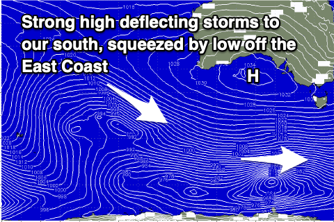 A deepening low will form in a surface trough off the southern NSW coast this weekend, squeezing a strong, slow moving high that's pushing in from the west.
This will bring average, onshore S'ly winds tomorrow, light to moderate in strength along with a mix of grounswell and mid-period S/SW energy from today.
Sets to 3-4ft are due on the Surf Coast, 5-6ft to the east, and there's a very slim chance of an early W'ly west of Melbourne but don't bank on it.
A slight drop in size is expected Sunday but not below 3ft on the Surf Coast and 4ft to occasionally 5ft to the east but winds look a little worse and moderate from the S/SE.
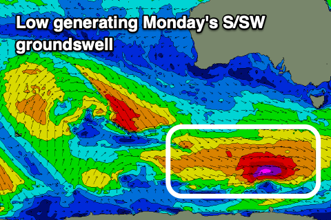 Into Monday, our new pulse of S/SW groundswell is on track, generated by a strong but fast tracking polar low pushing east this evening and tomorrow. A tight fetch of severe-gale to storm-force W/NW winds are due, acting on top an active sea state, with the swell due to arrive just before dawn Monday but peak through the day.
The Surf Coast should build back to 4ft with 6ft sets to the east but with persistent S/SE winds.
Come Tuesday we may see winds tip back to the E across the Mornington Peninsula and Phillip Island along with a drop in S/SW groundswell from 3ft and 4-5ft respectively.
We should finally see winds swing back to the N/NE on Wednesday as the low off the East Coast pushes away to the east and there'll be a fun new pulse of mid-period S/SW swell in the water.
The source will be another polar front, generating pre-frontal W/NW winds followed by post-frontal W/SW-SW winds, generating a fun 3ft+ wave on the Surf Coast, 5ft+ to the east. From here on into the end of the week the size will ease and winds look to revery back to the W/NW on Thursday ahead of another trough and weak S/SW change during the afternoon.
There's no major swell due into the weekend but we could see a moderate sized SW groundswell for early the following week with favourable winds for the beaches. More on this Monday. Have a great weekend!
Comments
SE winds in July? Feck off Nina
Ditto PLStocks
so clean out there this morning down the surf coast! pleasantly surprised.
That slim chance westerly came through Craigos
Noice!
Pretty lumpy swell but yeah nice and clean on top.
Super clean on the east. Is this new swell overstated on the charts due to the westerly angle? Small out there this morning around the killy to liptrap stretch
Just realised we are probably at the low point between swells. Was a foot or two bigger yesterday arvo…and clean! Just a few lumps spoiling it here and there but otherwise super fun
Today's swell isn't showing well on the buoys. The low might have tracked a bit too fast east.
Bugger - will keep my eye on it