Persistent winds from the south-western quadrant

Victorian Surf Forecast by Craig Brokensha (issued Monday 6th June)
Best Days: Today Surf Coast, keen surfers early tomorrow Surf Coast, similar Friday and Saturday mornings, Tuesday morning next week Surf Coast
Features of the Forecast (tl;dr)
- Mix of swells tomorrow with early fresh W/NW winds, tending strong SW mid-morning
- Moderate sized mid-period S/SW swell for Wed AM with strong W/SW-SW winds (possibly W'ly early on the Surf Coast)
- Building mid-period S/SW swell Thu, peaking Fri AM with gusty W/NW tending strong SW-W/SW winds
- Building mid-period S/SW swell Sat with gusty W/NW tending strong SW-W/SW winds
- Large S/SW swell Sun with strong SW-S/SW winds, easing Mon with fresh S/SW-SW winds
- Small-fading S/SW swell Tue with W/NW winds
Recap
Fun waves across the Surf Coast on the weekend with an infrequent, mid-period W/SW swell to 2-3ft on the magnets Saturday, similar yesterday morning before building more into the late afternoon to a more consistent 3ft. Exposed locations to the east were wind affected and choppy.
Today we've got a mix of mid-period swell and inconsistent SW groundswell with better 3-4ft sets on the Surf Coast though slightly lumpy/raw conditions. Winds will remain favourable all day for the Surf Coast as the swell also holds.
This week and weekend (Jun 7 - 12)
Cold, windy and with lots of snow.
 Following last week's cold outbreak we're now under the influence of a second but more prolonged cold episode as a strong node of the Long Wave Trough pushes across us and then very slowly east.
This will project a flurry of cold, polar fronts up and across us during this week, initially weak in strength ahead of some stronger activity mid-late week, but by the time the swells arrive, we'll be under a less favourable south-western flow on the back of the LWT node.
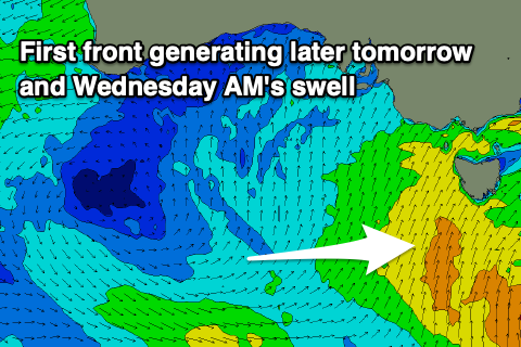
Looking at the coming days, and today's inconsistent SW groundswell will ease tomorrow with some building, weak S/SW energy tomorrow afternoon and more so Wednesday.
 Fetches of S/SW winds will be projected up and into the state with tomorrow coming in around 3ft+ on the Surf Coast, 4-5ft to the east, a touch bigger Wednesday morning but easing from 3-4ft on the Surf Coast and 4-6ft to the east.
Conditions won't be ideal but OK early tomorrow with a fresh W/NW breeze, shifting strong SW mid-morning, with Wednesday seeing strong SW-W/SW winds (possibly W'ly for a period early on the Surf Coast).
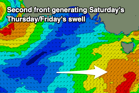
From Thursday we should see some new, mid-period S/SW swell building through the day, generated by a strengthening polar front projecting up and into us, with a touch more vigour than tomorrow's. This will be followed by further systems into Friday and the weekend, though the strongest fetches of gale-force winds will develop too far east of our swell window, block by Tasmania.
Regardless we should see moderate sized + pulses of S/SW energy, initially filling in Thursday, peaking Friday morning, with a secondary stronger pulse for Saturday afternoon and third for Sunday.
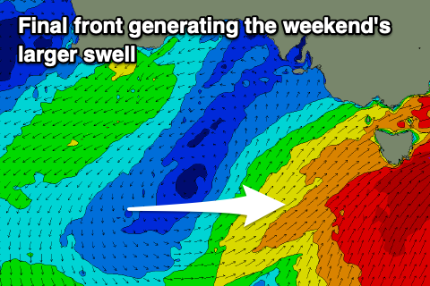 Size wise Friday morning's should come in around 4ft on the Surf Coast, 5-6ft to the east with Saturday's coming in at a similar if not slightly bigger size, strongest Sunday and to 5-6ft and 6-8ft respectively.
Locally winds look to be generally strong from the SW-W/SW through the end of the week, but depending on the timing of each successive front we'll see winds tip W/NW through the mornings for short periods on the Surf Coast.
At this stage this looks to be most likely Friday and Saturday with less favourable SW tending S/SW winds on Sunday.
Into next week the swell will ease as winds improve, though Monday looks to remain mostly onshore, clean on the Surf Coast Tuesday but easing from 2ft+. The rest of next week looks clean but small owing to the blocking effects of a high sitting to our west later this week and on the weekend but we'll look at this closer on Wednesday.
Comments
The windy chart suggests brown trousers conditions for Sunday, but swell period is less so overall not so big?