Fun weekend, building windy swells next week

Victorian Surf Forecast by Craig Brokensha (issued Wednesday 25th May)
Best Days: Saturday and Sunday Surf Coast (possibly late afternoon east of Melbourne), Monday exposed beaches, Wednesday Surf Coast
Features of the Forecast (tl;dr)
- Small, inconsistent mid-period SW swell building Fri PM (with light-mod S/SW winds), with a secondary better pulse for Sat PM, easing Sun
- N/NW tending NW winds Sat, NW tending variable winds Sun (possibly late N east of Melbourne)
- Easing mid-period SW swell Mon AM, with a moderate sized W/SW swell for the PM
- Strengthening N/NE tending E winds Mon
- Strong SW winds Tue with a moderate + sized increase in local SW swell
- Easing localised swell Wed with W/NW tending SW winds
- Better mod-large W/SW groundswell late week/weekend
Recap
Great waves Monday afternoon on the exposed beaches with a beautiful glass off, with smaller, fun 2ft+ sets left on the exposed beaches yesterday. Today it's back to a slower 2ft but clean with tiny to flat surf to the west.
This week and next (May 26 - Jun 3)
There's nothing major due into the end of the week with the surf due to remain small to tiny tomorrow under a favourable N/NE breeze across the exposed beaches. For the patient there should still be the odd 1-2ft set, tiny on the Surf Coast.
Friday morning will remain tiny with a W/NW offshore, shifting S/SW into the afternoon as a weak low moves through, bringing a shallow change.
Some new, inconsistent and small mid-period SW swell is due to start building but Saturday and Sunday are better regarding the surfable parts of this swell.
The source of these swells was a broad but poorly structured and distant polar low that formed around the Heard Island region on the weekend and projected east over the past couple of days.
Two distinct pulses of mid-period swell are due, the first for later Friday and Saturday morning being followed by a slightly better pulse Saturday afternoon, easing Sunday.
Size wise the first should see inconsistent 2ft to possibly 3ft sets across the Surf Coast Saturday morning, with the secondary pulse providing more convincing 2-3ft sets, 4ft+ to the east in the morning, with 3-5ft surf into the afternoon.
Sunday morning should reveal similar sized waves, easing through the day.
Winds look favourable in the wake of Friday's weak change on Saturday with a N/NW tending NW breeze, with Sunday due to see NW tending variable winds, possibly tending N'ly east of Melbourne later. With this outlook the beaches to the east look a bit hit and miss and not ideal.
 Monday will be the pick east of Melbourne but smaller with easing 3-4ft sets under a strengthening N/NE tending E'ly breeze.
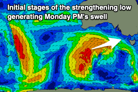
A fresh pulse of mid-period W/SW swell is due to fill in Monday afternoon, generated by the initial stages of a strengthening polar front come low in the Bight on the weekend.
Pre-frontal W/NW winds will be followed by SW winds, before the fetch angles more S/SW and projects up into the Bight and South Australia through the weekend and Monday.
Only this initial stage of the progression looks favourable for swell production, with a fun kick in size to 3ft+ on the Surf Coast, 4-6ft to the east with those E winds.
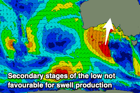 As the low moves east on Tuesday we'll see a strong SW change move through, bringing poor conditions and some localised windswell to the mix. There's a chance for an early W/NW breeze depending on the movement of the low but check back here Friday and Monday for the final confirmation.
The localised SW swell from the backside of the low looks to build to 4-5ft through Tuesday on the Surf Coast, 6ft+ to the east, easing quickly through Wednesday from 4ft and 6ft respectively as winds revert back to the W/NW with an approaching front.
It won't be anything special but there should be some fun options in protected spots.
As touched on in Monday's notes, we've got a better swell produced due to fire up behind the broad, cold inland low, with a strong low due to form south of Western Australia early-mid next week.
This looks to generate a moderate-large W/SW groundswell for late next week/weekend under favourable westerly winds, but check back Friday for more on this.
Comments
Does this guy: Hako o hakonde ..., sheepy, or southy, or indo still exist in these forums? if so want to get in touch ahah
It's been a great week to be catching up on work.
I like sarfborting