Mixed period but there are windows

Victorian Surf Forecast by Craig Brokensha (issued Friday 3rd December)
Best Days: Tomorrow morning protected spots, Monday on the beaches
Features of the Forecast (tl;dr)
- Moderate sized+ W/SW groundswell kicking later today with mod-fresh S/SW winds, easing tomorrow with W/NW tending strong SW winds late morning
- Easing surf Sun with light-mod S/SE-SE morning winds, stronger into the PM
- Easing swell Mon with fresh N/NE winds
- Tiny Tue with W/SW winds
- New, mid-period SW swell Thu with strengthening S'ly winds, easing Fri as gusty S winds persist
Recap
The surf hit a low point yesterday morning and there was a window of variable offshore winds ahead of a shallow SW change that brought sea fog temporarily into the Mornington Peninsula back beaches.
This morning we've got an early light W/NW breeze and some inconsistent new W/SW swell. It's only 2ft on the Surf Coast and 3ft to the east but we should see more size develop through the day along with a stronger pulse of W/SW groundswell late but with moderate to fresh S/SW winds.
This weekend and next week (Dec 4 - 10)
The window of lighter W/NW winds this morning will be fairly short-lived with winds due to swing S'ly over the coming hour as a mix of long-range and closer-range W/SW groundswell fill in. (Update they've just done so on the Surf Coast).
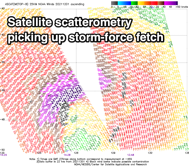
The source of the best and most consistent pulse of swell later today was a strong low that fired up under Western Australia, pushing east while generating a fetch of gale to severe-gale winds. Satellite scatterometry picked up a tight bunch of storm-force winds and this should see the size kicking to 4ft+ on the Surf Coast and 6-8ft sets later today. Conditions will be average though with that moderate to fresh S/SW breeze.
This swell is due to ease through tomorrow but the morning should be a similar 4ft+ on the Surf Coast and 6-8ft to the east and we've got an offshore W/NW breeze due to hold until late morning when a stronger SW'ly kicks in. Therefore there should be some good quality waves on offer in protected spots ahead of the shift in wind.
Sunday still looks a bit average as the swell eases under a light to moderate S/SE-SE breeze. Dropping sets from 3ft are due on the Surf Coast, 4-5ft to the east and while a bit bumpy it'll be workable with the light breeze.
Moving into next week, Monday looks the pick with moderate to fresh offshore N/NE winds ahead of another trough which will bring onshore winds for the rest of the week.
Swell wise we're looking at easing surf from around 2ft on the Surf Coast but a really fun 3-4ft on the Mornington Peninsula. Conditions will remain clean all day but get in through the morning for the most size.
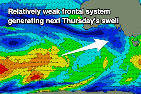 Come Tuesday weak W/SW-SW breezes are due as the trough moves in and these will strengthen into the evening as a high starts to squeeze in behind it. The trough is forecast to form into a low off the southern NSW coast, squeezing the high which will result in S'ly winds persisting the rest of the week, spoiling a new, moderate sized mid-period SW swell.
The swell will be generated by a broad but distant polar frontal progression firing up east of the Heard Island region, though weakening while pushing under the country early next week. We should see the swell filling in Wednesday evening and peaking Thursday, offering 3ft waves on the Surf Coast, 4-5ft to the east but with that southerly breeze.
Longer term winds should improve from next weekend with an additional pulse of mid-period swell, but we'll have a closer look at this on Monday. Have a great weekend!
Comments
Will the swell run into western port on Saturday morning or will it be too WSW?
It should get in but size wise it'll be on the smaller side of the coin.
If you have to ask the question you’re better off heading to Torquay
Sorell is looking impressive.
Still a lazy 2 ft on the SC reefs. MP is where it’s at tomorrow..
I reckon the flotilla of SC will already be here.
You were bang on about that low in the Bight not getting as intense as expected. Chapeau!
Still need to lift your game with those temps next week, though. Not good enough!