Slow week, very active into next

Victorian Surf Forecast by Craig Brokensha (issued Monday 13th September)
Best Days: Tomorrow morning for the keen, Friday exposed beaches, Saturday and Sunday Surf Coast, next week protected spots
Features of the Forecast (tl;dr)
- Easing W/SW groundswell tomorrow with variable winds (W/NW Surf Coast, E/NE to the east) ahead of S/SE sea breezes
- Small, inconsistent mix of SW and S/SW swells for Wed PM with dawn E/SE winds, tending E/NE ahead of fresh S/SE sea breezes
- Easing mix of small, inconsistent swells Thu with moderate E/SE-E winds ahead of fresh S/SE sea breezes
- Inconsistent mid-period W/SW swell Fri with strengthening NE tending N/NE winds
- Stronger, but inconsistent W/SW groundswell for Sat, easing Sun with strong N/NW tending NW and then W/NW winds Sat, N/NW tending W/NW Sun
- Larger run of windy surf next week, best in protected spots
Recap
Friday afternoon's pulse of mid-period swell over-performed with sets pushing to 6ft on the Surf Coast and a large 8ft on the Mornington Peninsula as winds remained favourable for most locations. The Mornington Peninsula cleaned up nicely after lunch with the Surf Coast also remaining clean.
The swell dropped right back into Saturday though leaving 3ft+ waves on the Surf Coast swell magnets and 4-5ft surf to the east, clean early before winds shifted to the west late morning.
Yesterday was fun on the Surf Coast again with building levels of mid-period W/SW swell with favourable though strong W/NW winds, giving into an onshore change early afternoon as the swell continued t build. Today we've got groundswell in the mix but average to poor conditions under a fresh S'ly wind owing to a trough moving through.
This week and weekend (Sep 14 - 19)
As touched on in Friday's update, the coming week is much slower and smaller than what we've been seeing the last few weeks, with today's trough due to push off to the east as a high starts to slowly move in from the west.
The slow moving nature of the high will mean winds will take a while to improve (while also blocking our immediate swell windows), being variable tomorrow morning before tending more easterly through Wednesday and Thursday, true offshore Friday.
Swell wise, today's W/SW groundswell will ease back through this afternoon, dropping further tomorrow from 3ft on the sets across the Surf Coast magnets, 4-5ft to the east. Winds should be variable (likely E/NE to the east and W/NW to the west), with some lump out there from today's onshore winds, with S/SE sea breezes kicking in through the day.
Wednesday morning will be smaller and back to 1-2ft on the Surf Coast, 2-3ft to the east and winds look to improve through the morning, possibly E/SE early on the Mornington Peninsula but tending E/NE ahead of fresh S/SE sea breezes. Our new, inconsistent S/SW groundswell for the afternoon is a little dicey, with it generated by a late forming polar low south-west of Tasmania today.
 This now looks to be a little too late to generate any size at all, with some distant long-range energy also in the mix from the south-west of Western Australia. The models are incorrectly combining the groundswell with mid-period energy, over-forecasting the size and I'd only expect surf to the 2ft range on the Surf Coast, 3ft+ to the east.
This swell will then ease back through Thursday from an inconsistent 2ft and 3ft respectively. Conditions will be a little hit and miss again with E/SE-E winds through the morning, fresher from the S/SE into the afternoon.
Into Friday and the weekend, inconsistent but better levels of long-range W/SW swell are due across the state, initially mid-period on Friday and then better groundswell energy on the weekend.
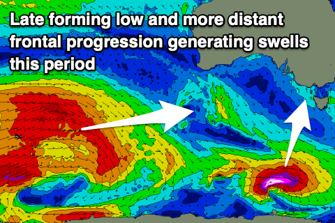
All this activity is currently being generated by broad but not overly strong polar frontal activity around and just east of the Heard Island region. Friday's pulse will be generated by the initial weakest stage of the progression, with inconsistent 2ft sets due on the Surf Coast swell magnets, 3ft+ to the east but with much better, strengthening NE tending N/NE winds, favouring the beaches.
A stronger and slightly better groundswell pulse from the strongest part of the progression (image above) is due to fill in Saturday, likely peaking into the afternoon with the Surf Coast offering inconsistent 3ft waves with 4-5ft sets to the east. Winds will swing around to the N/NW-NW and then W/NW into the afternoon as a slow moving mid-latitude low pushes in from the Bight.
There's no major swell due from this low as it pushes across us Sunday, bringing strong N/NW tending W/NW winds, with the bulk of the swell generating fetch sitting too far north of our swell window until the weekend.
 Instead Sunday looks to see similar amounts of inconsistent groundswell compared to Saturday, with some new, mid-period W'ly swell showing later in the day.
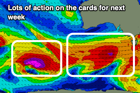
Of greater significance is the strengthening frontal progression this low is due to draw up from the Southern Ocean in its wake early next week.
At this early stage this looks to be quite impressive with a conveyer belt of significant fronts, bringing large, windy surf through next week, best suited to protected spots under a westerly flow, but we'll have a closer look at this in the coming updates.