Make the most of the coming days

Victorian Surf Forecast by Craig Brokensha (issued Monday 5th July)
Best Days: Late tomorrow Surf Coast, Wednesday, Thursday morning for the keen
Features of the Forecast (tl;dr)
- Easing W/SW swell tomorrow with moderate W/NW winds
- New, mid-period S/SW swell kicking on dark tomorrow, peaking Wed AM, then easing
- N/NW tending N/NE winds Wed
- Easing surf Thu with local offshore tending NE winds, similar Fri with a small S/SW swell
- Small, inconsistent W/SW groundswell building Mon, peaking Tue with NW winds
Recap
In the end there was nothing to worry about regarding Saturday's slightly tricky and flukey swell, with it pushing in strongly and offering great 4-5ft sets on the Surf Coast reefs, more 6ft on the sets to the east under favourable, and persistent N/NW winds. A great, all day afair of pumping surf.
The swell backed off a touch into yesterday morning as winds held from the NW, while today we've got a weaker mix of windswell and mid-period energy to 2-3ft on the Surf Coast, bigger to the east.
This week and weekend (Jul 6 - 11)
Tomorrow will be smaller again, with today's mix of weaker swells due to reach a low point ahead of a good, new mid-period S/SW swell
The Surf Coast looks to be 2ft, with 3-4ft sets across the Mornington Peninsula along with a moderate W/NW wind that will persist most of the day.
Into the late afternoon, we should see some new, mid-period S/SW swell filling in, peaking Wednesday morning. The source of this swell is a relatively weak but favourably projecting polar fetch of W/SW tending SW winds through our southern swell window yesterday and today (south-west of Tasmania).
 Size wise, the Surf Coast should build to 3ft on the sets on dark, 4ft+ to the east, with Wednesday morning easing back from 3ft+ and 4-5ft respectively.
Conditions on Wednesday will be great for most regions with a light to moderate N/NW tending variable N/NE breeze opening up plenty of options for the keen.
It'll be worth making the most of this swell, as once it eases, there's nothing too major on the cards at all until next week.
We'll see the size ease back Thursday from around 2ft on the Surf Coast, 3ft to the east and with favourable, local offshore (N/NW Surf Coast, N/NE to the east) tending variable NE winds.
A small, reinforcing pulse of weaker S/SW swell looks to keep the Surf Coast around 1-2ft on Friday, 2ft to maybe 3ft to the east, generated a weak front firing up behind the one linked to Wednesday's swell.
Conditions will remain clean with local offshore winds, tending NE into the afternoon again.
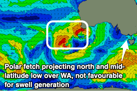
Looking over to our west, and a mid-latitude low with multiple fronts spinning around it is impacting Western Australia, but all the fetches will be too far north of us to generate any swell. This slow moving low will also block our main swell windows with nothing of note due at all next week as another similar low fires up in a similar spot.
We may see some, inconsistent small W'ly energy through Monday/Tuesday next week, though size wise it'll be lucky to top 2ft+ on the Surf Coast and 3-4ft but with gusty NW winds.
We'll keep a close eye on this and a possible increase in frontal activity (though south-west of Western Australia) mid-late month.