Swell a plenty and favourable winds

Victoria Forecast by Craig Brokensha (issued Wednesday 13th May)
Best Days: Surf Coast tomorrow, Friday both regions, Saturday morning both regions, Sunday Surf Coast, Monday through Wednesday next week
Recap
A drop in swell yesterday though still hanging in at 2ft to occasionally 3ft on the Surf Coast magnets, 4ft to the east with morning N'ly winds, shifting more N/NW through the day.
Today our new W/SW groundswell has filled in with 3ft+ waves on the Surf Coast magnets and 5-6ft sets to the east, but conditions were a little suss with early light W'ly winds ahead of a SW change.
This week and weekend (May 14 - 19)
Today's inconsistent W/SW groundswell will hold all day, easing through tomorrow, but a new reinforcing mid-period SW swell maye show later today, but peak tomorrow morning.
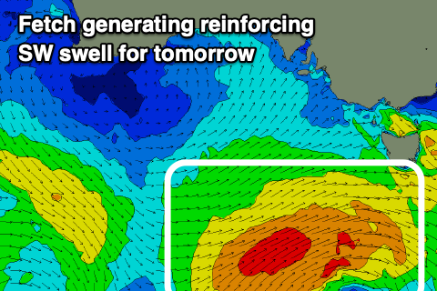 The swell has been generated by the remnants of the frontal progression linked to today's swell, with it re-intensifying south-west of us yesterday, projecting a fetch of strong to gale-force winds through our south-western swell window.
More consistent 3-4ft sets are due on the Surf Coast tomorrow morning, 5-6ft to the east before easing through the day and dropping further from 2ft+ (3ft sets still at magnets) and 4ft+ respectively Friday morning.
Conditions will be favourable for protected spots tomorrow with a light W/NW offshore, tending variable ahead of possible weak sea breezes.
Friday looks cleaner across the exposed beaches now with a morning N'ly breeze, tending N/NE and then variable into the afternoon with NW tending E/NE winds on the Surf Coast.
Moving into Saturday a small reinforcing W/SW swell should stop the size easing further, generated by the first in a conveyer belt of cold fronts moving in from the west from tomorrow. This won't be especially strong and will generate a tight burst of strong to gale-force W/NW-W/SW winds, keeping the Surf Coast around 2ft with 3-4ft sets on the Mornington Peninsula.
 Conditions look favourable for both coasts with a moderate N/NW'ly on the Surf Coast, N-N/NW on the Mornington Peninsula, tending NW into the afternoon.
From Sunday through Wednesday next week we'll see better pulses of W/SW groundswell, with the models aligning with EC resulting in no major spike in size through this period.
Multiple mixed fetches of gale-force W/NW winds will move through our medium-range swell window, west-south-west of WA, with embedded lows generating bursts of stronger severe-gale winds.
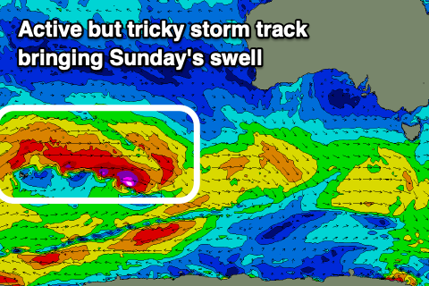
The progression will weaken when moving under the country Friday, with some new inconsistent W/SW groundswell due from this flurry Sunday, building through the day. Building sets to an inconsistent 3ft are due across the Surf Coast Sunday, 4-5ft+ to the east, better Monday and to 3ft+ and 5-6ft respectively.
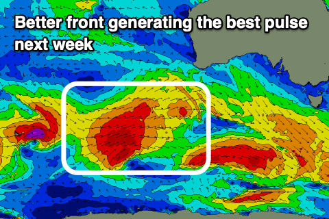 A stronger and more consolidated front projecting gale to severe-gale W/SW winds on the back of this progression through our western swell window, south-west of WA should generate a better W/SW groundswell for later Monday and Tuesday morning. Sets to 4ft are due on the Surf Coast, 6ft+ to the east, easing slowly from Tuesday afternoon, further Wednesday.
Now, with activity staying some distance from us, we'll see favourable winds through this period. Sunday looks good with a light NW tending variable breeze, if not for weak SE sea breezes, but into next week local offshores are due each morning (N/NW Surf Coast, N/NE to the east), tending N/NE Monday afternoon, N-N/NE Tuesday with stronger N'ly winds on Wednesday. We'll confirm this Friday though.
Comments
Deliver us from evil Craigoss!
You need to move to western Vic now till end of November then shack up in Tullamarine for dec and Jan then park your arse at angourie for Feb and March. And after that you Will realize that the hoax coast is not great at all. But greatfull we have a beach that gets west swell at the same time.