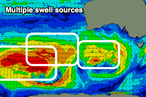
Multiple swell sources for the coming period

Victoria Forecast by Craig Brokensha (issued Wednesday 22nd April)
Best Days: Every day besides Friday
Recap
Yesterday's first pulse of W'ly groundswell was just that, west and slow in nature with inconsistent 3ft sets through the morning on the Surf Coast, a bit better into the afternoon with a touch more size and consistency. Phillip Island was great all day, while there was a window of clean conditions and solid waves on the Mornington Peninsula before winds shifted.
Today we've got a bit more energy across both regions with clean 3-4ft waves on the Surf Coast (below), bumpy and to 5-6ft to the east.

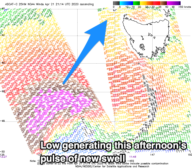
Our stronger SW groundswell for later this afternoon is on track, with satellite observations confirming a fetch of severe-gale SW winds around a low, moving through our swell window yesterday evening and early this morning. The low is now passing under Tassie with the swell due to kick later today to 4-5ft on the Surf Coast and 6ft to occasionally 8ft on the Mornington Peninsula but with onshore winds from mid-late morning.
This week and weekend (Apr 23 – 26)
 Later today's kick in new SW groundswell will be a short-lived pulse, owing to the fast eastward movement of the low that generated it through our swell window.
As a result we'll see the swell ease overnight and drop steadily tomorrow from 4ft on the sets early across the Surf Coast and 6ft on the sets across the Mornington Peninsula. Conditions are looking good all day though with a persistent and freshening N/NW breeze on the Surf Coast, N early east of Melbourne and then shifting N/NW through the day.
Friday will be smaller and persistent W/NW winds will favour the Surf Coast. Expect slower 2ft+ waves though, bigger but bumpy to the east.
From the weekend there are various differing and tricky swells sources on the cards from persistent Southern Ocean frontal activity.
The first and least favourable inconsistent swell is due Saturday. This W/SW groundswell has been generated by a strong but distant mid-latitude frontal progression projecting a fetch of W/SW gales through our far western swell window, north-east of Heard Island. The progression is currently weakening directly south-west of WA, with it due to break down further through today.
Due to the westerly nature of the swell and distance from our coasts, this swell will be extremely inconsistent on the Surf Coast and only come in around 3ft on the swell magnets, 2ft at most other locations with infrequent 4-5ft+ sets to the east.
A similar though slightly more consistent pulse is expected on Sunday, produced by a secondary fetch of strong W-W/NW winds moving through our swell window, under the country tomorrow, strengthening south-west of us on Friday.
We should see waves to 3ft on the Surf Coast, 4-6ft to the east, with a slightly bigger kick into the afternoon to 3-4ft and a more solid and consistent 6ft respectively.
This is then due to be followed by our inconsistent W/SW groundswell Monday, produced by various severe-gale W'ly winds through our far swell window just east of the Heard Island region over the coming days.
 Weaker fronts spawning off this broad system will move in through the weekend, producing additional but smaller mid-period swell energy early next week.
The inconsistent groundswell is due to peak Monday with 3-5ft sets on the Surf Coast swell magnets, likely more consistent into the afternoon, easing slowly Tuesday from 4ft. The Mornington Peninsula looks to be 6ft mostly, with the odd 8ft cleanup at times Monday through Tuesday morning.
Coming back to the local winds and Saturday should see N/NW tending variable breezes on the Surf Coast, likely tending variable N/NE on the Mornington Peninsula, while Sunday looks to offer an early W/NW offshore ahead of a strong SW change as a trough moves through. An approaching cold front will then swing winds back quickly to the NW Monday morning, fresh though easing and tending W'ly into the afternoon.
Tuesday will hopefully see local offshore winds as the swell starts to ease, but more on this Friday.
Comments
Notes out by 9.30! All hail Craigos the king!
Always! Ha, this helps..
Get out for a swim at least? Nice morning out there.
Good to see the normal autumn pattern starting to kick in here.
Just a shame about the abnormal crowds kicking in....60 at Bells this morn, 50 at Winky I was reliably informed. At 730. Jesus H. Christ, it's gone berserk. Maybe they're channeling the comp..?
Same everywhere around here this morning. When are these carnts gunna ditch surfing so they can start feeding their families/themselves/paying bills etc???
Dont mean to brag, but I am, I surfed a pumping 6ft right to meself today
With the major expansion of Torquay in recent years, these numbers will be common place and probably just a start as so many new local kids and young adults grow up surfing. So while current locals will moan about Melbourne crew coming down, in a few years it'll be stacked with even more 'locals' + Melbourne crew.
Torquay has grown by around 6000 people since 2012. Probably gonna have some impact in the water.
I dont get where they come from. Numbers up on this coast too but why. Very noticeable in the morning. I can’t work out what work demographic they’re from. You start to recognise the weekend warriors but there seems be a new breed about
Possibly all the hospo/retail workers that now no longer have to get to work, or haven't worked late (hospo), that are able to hit the road earlier for mid-week surfs? Plenty of people now with their schedules completely changed. Even those working from home can probably scoot down for a super early session then be back by mid-morning
There are a lot of commuters that usually head towards the SE and city each day that are now working from home. That gives them a couple hours in the morning to surf.
Lots of new faces in 17-21 age group too (that I assume are local). No casual work, uni, tafe or pubs to keep them busy I guess
Hey Craig, going a little off topic but with the BOM forecasting wetter than average conditions into winter due a warmer than average eastern Indian Ocean thus bringing more moisture into our region, what may this mean for the snow season (if we have one)?
They're also forecasting a high chance of warmer than average temperatures over winter so is that likely to mean more rain than snow for the Alps or is this when the Southern Annular Mode comes into play? I guess what I'm trying to wrap my head around is can a negative IOD phase have an impact on the SAM outlook (pushing SAM,s into positive phase) which is also relevant to the winter surf outlook too.
Go to the Buller website and look at annual snowfall history. I think it goes back 30 years. Absolute lottery if you have a look and try and predict. But an educated guess could be quite accurate in 2020 possibly.
https://www.mtbuller.com.au/Winter/snow-weather/snow-cams/historical-sno...
Absolutely vicco11..... absolutely. I sucked my thumb put it out of the window this morning and I can concur that this will be the case.... rest easy there will be powder on the hills and mackin' kegs in the water for those with faith..... don't worry your little head about the Science... its fake news.
Haha jeez I'm not trying to pick the best weekend to head to the mountains or which region to surf 3 months out, I'm just trying to expand my knowledge on how certain weather drivers like the IOD can influence others like the SAM. I did some digging on the net but didn't have much luck, maybe because the IOD and SAM are not correlated at all? I also understand the sudden stratospheric warming event which was effecting the SAM last year has now gone back to normal so I'd imagine the SAM should generally not push as high up as we saw so often last year. Anyone else with some knowledge please correct me if I'm wrong :)
https://globalnews.ca/news/6494040/groundhog-day-2020/
You just need to find the right animal, then wait for it to appear. And because Craig uses different models to forecast, so can you:
https://www.foxnews.com/great-outdoors/california-tortoise-groundhog-day
:)
So, the wetter forecast weather is from warm water off Indonesia and North West WA. This will provide moisture to north-west cloud-bands which track south-east across the country.
Whether they arrive with cold air or not, injected from cold fronts from the south-west is the big question. It'll be the make or break between big dumps or just rain. The BOM do have it a bit warmer than normal across the mountains so this is not good.
As you pointed out, we can forecast strong negative SAM events now following a Sudden Stratospheric Warming event, but that's more into spring and is very rare.
Otherwise forecasting the SAM beyond a couple of weeks isn't really doable at the moment. And as you said the IOD and SAM are independent as far as we know so far.
Hows about a Indo forecast ......just for the hell of it
Looks good! Trades have kicked in. Big on Monday and Tuesday.