A few options but not a great week

Victoria Forecast by Craig Brokensha (issued Monday 23rd December)
Best Days: Keen surfers both coasts tomorrow morning, desperate surfers exposed beaches Wednesday morning, exposed beaches Saturday morning, desperate surfers exposed beaches Sunday morning
Recap
Poor conditions Saturday with a small mix of swells and fresh onshore winds, but our large, powerful and rapidly building SW groundswell for yesterday did just that. Undersized early it built rapidly through the morning and peaked into the afternoon while tending more S/SW in direction.
Options were limited but there were some standout sessions in the onshore wind. Size wise it looks like the Surf Coast reached 6-8ft and 8-10ft to the east, with the swell easing in size today, though still large out of the S/SW and to 4-6ft and 6-8ft respectively. Winds are still onshore but there are workable options across the state.
This week and weekend (Dec 24 - 29)
With the large and significant swell from the 'bombing low' now on the decline, we'll continue to see the surf fade in size and power over the coming couple of days.
Winds will continue to spoil the party tomorrow, though only light to moderate out of the S/SE, so keep your expectations low and aim for easing 3ft waves on the Surf Coast, 3-4ft+ on the Mornington Peninsula.
The afternoon will be poor with strengthening E/SE winds kicking up a late increase in junky windswell that'll ease into Christmas morning, mixed with the easing S/SW swell.
 Conditions should become cleaner on the beaches Wednesday morning with a light E/NE tending variable wind ahead of sea breezes but the swell looks average, easing from 1-2ft on the Surf Coast and 2ft on the Mornington Peninsula.
Thursday will be a lay day with no new swell and onshore S'ly winds.
Our new inconsistent W/SW groundswell for Friday is still on track though, but so are the onshore winds, cleaner as it eases Saturday.
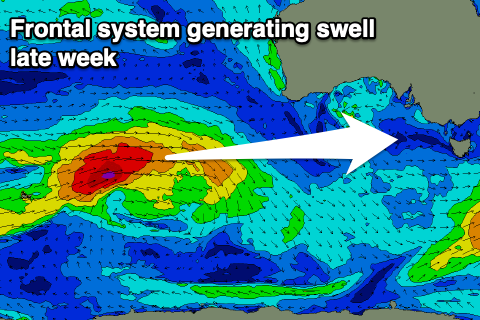
The swell was generated by a strong frontal system firing up west-southwest of WA in our far swell window, generating a fetch fetch of W/SW gales while tracking east. It's now weakening south-west of WA and we'll see the swell arriving overnight Thursday and building through Friday, though very inconsistent.
The Surf Coast should build to an infrequent 2-3ft on the swell magnets, 4-5ft on the Mornington Peninsula, but winds will linger out of the S/SE creating average conditions.
Saturday looks the day to surf with winds swinging N/NE through the morning as the swell eases from 2ft+ and 3-4ft respectively.
Sunday will also be clean in the morning but the swell small to tiny and easing.
Longer term another strong frontal system is expected to fire up in our western swell window, under WA, generating a better W/SW groundswell for early next week with westerly winds, but more on this Wednesday. Merry Christmas!