Large windy surf for next week

Victorian Surf Forecast by Ben Matson (issued Wednesday 20th March)
Best Days: Fri: fun waves east of Melbourne, building later. Sat AM: good surf at most open beaches with NE winds (biggest east of Melbourne), though easing in size. Mon/Tues/Wed: large surf with dicey conditions, though pockets of W/NW winds are possible.
Recap: Small persistent swells with mainly E/SE thru’ SE winds. Not much on the Surf Coast, with variable conditions east of Melbourne as winds have occasionally veered S/SE at times.
This week (Mar 21 - 22)
Today’s Forecaster Notes are brought to you by Rip Curl
*this week's Forecaster Notes will be occasionally brief and erratic, as Craig is on annual leave - to receive notification when they’re updated, please update your account preferences*
No major changes for the rest of the week.
We’re looking at small residual swells on Thursday and early Friday (3ft east of Melbourne, smaller to the west) ahead of a Friday afternoon pulse in new energy that should provide some decent sized sets (4-5ft+) to exposed beaches east of Melbourne very late in the day.
SE winds will tend E’ly through Thursday and strengthen across Bass Strait into the afternoon and further into Friday, which should give rise to a small local SE swell west from Torquay at some point Friday (most likely the the afternoon). But no great size or quality is expected.
Local winds will be mainly out of the east both days but as we’ve seen this week, there are likely to be periods of light variable winds across the northern periphery of Bass Strait.
All in all, it’s really best suited to the open beaches east of Melbourne, with Friday a better choice as lingering SE winds early Thursday will probably result in initially lumpy surface conditions.
This weekend (Mar 23 - 24)
Our current blocking pattern will break down over the coming days, leading to a wind swing to the NE early Saturday ahead of a late afternoon W’ly change as a trough pushes across the region.
Saturday morning’s surf will consist of small peaky SE windswell around 2ft+ (Surf Coast, mainly west from Torquay) and easing SE groundswell from Friday’s late pulse (3-5ft open beaches east of Melbourne, also easing).
The weekend’s approaching fronts are not expected to impact the state until Monday, soo Sunday will likely see small residual swells and lighter W’ly winds becoming variable under a pre-frontal trough. There is a chance for some small W/SW swell from the first front in the progression (rearing up under WA late Fri/Sat), but it won’t reach Victoria until very late Sunday at the earliest. Let’s have a closer look on Friday.
Next week (Mar 25 onwards)
We’ve got one heck of a complex, powerful weather progression expected to push through our immediate swell window from Saturday through Wednesday (see chart below, for late Sunday).
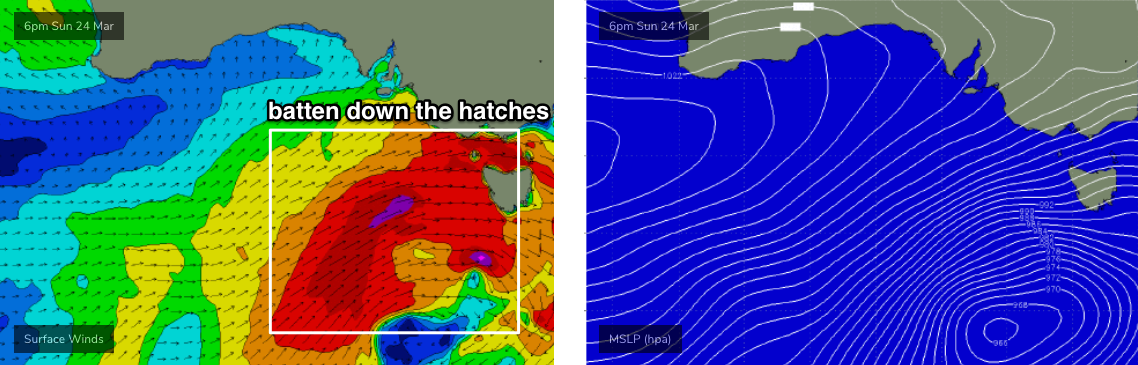
Most of the groundswell generated over the weekend further out in our swell window (beneath the continent) will arrive concurrently with the primary front/low above, which itself will be generating a large local swell - so expect a noisy mix of windy swells that could reach 8ft+ across the Surf Coast and 10-12ft across exposed beaches east of Melbourne (of course, terribly blown out with onshore gales).
From a forecasting perspective, on Friday I’ll be looking for possible windows of opportunity early next week where winds could swing temporarily W/NW - favouring the Surf Coast and Western Port for windows of rideable conditions. At this stage early Monday and early Tuesday are possible candidates, but it’s too far out to have any confidence. Otherwise, it'll be sheltered locations only through this time frame.
Beyond this we’ll see strong though easing swells Wednesday onwards ahead of the next round of strong fronts sometime around the following Friday or Saturday.
See you Friday!