Large swells to come with varying winds

Victoria Forecast by Craig Brokensha (issued Wednesday 6th March)
Best Days: Surf Coast tomorrow morning, selected locations to the east later in the day, Surf Coast Friday, selected spots Saturday morning, Sunday both coasts, Tuesday and Wednesday next week protected spots
Recap
Easing fun W/SW swell with OK conditions across selected locations yesterday with lighter and more variable onshore breezes.
Today our new W/SW groundswell event is on the build with Cape Sorell showing plenty of size and power. The Surf Coast was a clean 3ft or so early but has since increased further, with stormy large waves on the exposed beaches east of Melbourne.
We should see the Surf Coast building further towards 4-5ft this afternoon/evening as winds shift SW, with 6-8ft sets on the Mornington Peninsula.
Today’s Forecaster Notes are brought to you by Rip Curl
This week and weekend (Mar 7 - 10)
Today's mix of building medium-range and long-range W/SW groundswells are due to peak this evening/overnight, easing back through tomorrow from 4-5ft at swell magnets on the Surf Coast (possibly a tad less consistent) and 6ft to occasionally 8ft on the Mornington Peninsula.
Winds will vary considerably through the day as another front pushes in from the west, swinging a morning NW breeze around to the E/NE into the afternoon and evening. The Surf Coast should be clean in the morning, as will other protected spots, with bumpy conditions into the afternoon as the beaches to the east start to clean up.
Friday will be smaller but great across the Surf Coast again with a NW-N/NW offshore and the swell isn't expected to drop below 2-3ft, with 4-5ft sets on the Mornington Peninsula as a pre-frontal fetch of W/NW winds produces a new swell for the afternoon. Winds may hold from the W/NW all day, but don't rely on it as they'll likely shift SW early afternoon.
Of greater importance is the fetch of severe-gale to storm-force W/SW winds trailing this pre-frontal fetch, produced by a tight and intense low developing south of the Bight tomorrow.
 We'll see this intense fetch generate a large though short-lived pulse of long-period SW groundswell to 4-6ft on the Surf Coast Saturday morning, and 6-8ft on the Mornington Peninsula.
Winds are an issue with the exposed large beaches being best and protected spots bumpy. A dawn E/SE breeze should tend E/NE for a period and then SE into the afternoon. Not ideal at all. We may see more variable winds, but we'll review this Friday.
Sunday looks much better with a N/NE offshore wind, freshening and tending more N'ly ahead of a late shift to the NW.
The swell will be easing though with fun dropping 2-3ft sets on the Surf Coast magnets, 4ft to the east.
Next week (Mar 11 onwards)
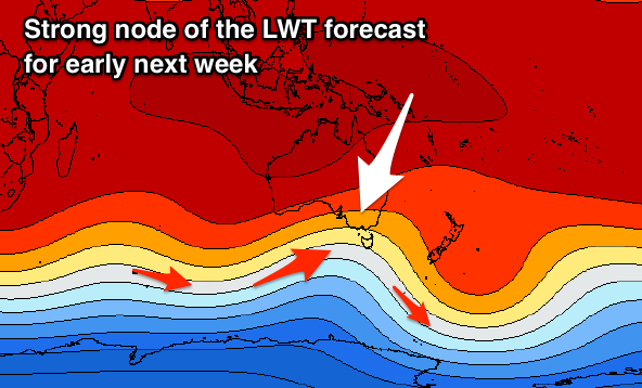
Moving into next week, and as touched on last update, a node of the Long Wave Trough is due to strengthen across the south-east of the country through the weekend. This will steer and strengthen a series of cold fronts from the Southern Ocean up and into us, the first moving through Sunday evening and bringing an average increase in mid-period W/SW swell with W/NW tending W/SW winds.
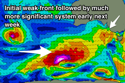 Behind this though a much more significant storm will strengthen south of WA and project an elongated fetch of severe-gale to storm-force W/SW winds through our south-western swell window, before projecting up towards us Monday and Tuesday.
A further increase in mid-period W/SW swell will be seen Tuesday ahead of a large long-period SW groundswell Wednesday which at this stage looks to peak in the vicinity of 6ft on the Surf Coast and 8-10ft on the Mornington Peninsula. Both models agree on the formation of this progression, but if it goes GFS's way we could expect a touch more size.
Winds look to swing from the W/NW-SW with the passing of the front Tuesday but another system approaching from the west will likely swing winds offshore from the W/NW as the swell peaks Wednesday but we'll have another look at this and the expected size again on Friday.
Comments
Very Autumn weather this morning, first time that I had to pull out the ugg's and grab a 3/2 in a while because that wind felt sooo cold. Small price to pay though, with the flick of the season switch coming into effect, bring it on huey:) but also, thanks for such a great summer, I'm calling it, 2018/2019 = the summer of luv!
Pumping Surf Coast this morning, photo from a mate, 4-5ft with rare 6ft cleanup..
Hardly anyone out either..........
Strange feeling with the warm water but cold air temp and wind. Great start to Autumn.