Active start to autumn

Victoria Forecast by Craig Brokensha (issued Friday 1st March)
Best Days: Protected spots Surf Coast dawn Wednesday, both coasts Thursday morning, Friday morning Surf Coast, Saturday, Sunday
Recap
A small and inconsistent increase in SW groundswell through Saturday, easing slowly Sunday with good winds for the exposed beaches most of the weekend.
This morning some new W/SW swell is on the build but conditions are bumpy with weak onshore winds across all locations. The Surf Coast magnets are expected to reach 2ft to possibly 3ft, with 4-5ft sets on the Mornington Peninsula as onshore winds remain relatively light until later afternoon.
Today’s Forecaster Notes are brought to you by Rip Curl
This week and weekend (Mar 5 - 10)
Our current small and inconsistent W/SW swell should ease through tomorrow and winds are now looking dicey for all locations. A lingering onshore S/SW breeze is due, though certain regions may see more variable winds early like Phillip Island and the Torquay region.
The swell will be small though and easing from 2ft on the Surf Coast swell magnets, and 4ft on the sets to the east.
Our attention shifts to the moderate to large W/SW groundswell due through Wednesday and Thursday. A strong low developed Friday evening in our far swell window and has since generated a fetch of severe-gale to storm-force W'ly winds south-west of WA.
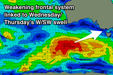 The storm has weakened a touch but is still generating an expansive fetch of gale to severe-gale W/SW winds south of WA this morning. The storm will continue east while slowly easing today, with the front pushing across us Wednesday.
We should see a moderate to large W/SW groundswell building through Wednesday and peaking later in the day/evening, easing Thursday.
Size wise, the Surf Coast should be around 3ft if not a little bigger Wednesday morning, building towards 4-5ft late in the day, 5-6ft on the Mornington Peninsula, reaching 8ft on the sets into the afternoon.
Winds will be average and fresh and gusty from the W/SW-SW, but the Torquay region will likely see a short period of better W'ly winds early.
Thursday is looking much better as the swell eases from a similar size to the evening before under a light morning NW tending N/NE breeze on the Surf Coast (afternoon sea breezes), variable tending N/NE winds on the Mornington Peninsula, also with afternoon sea breezes.
 The surf will continue to ease Friday with a morning NW breeze, tending W/NW ahead of S'ly sea breezes. Later in the day a new long-period SW should start to show, but Saturday will reveal the peak in energy and size.
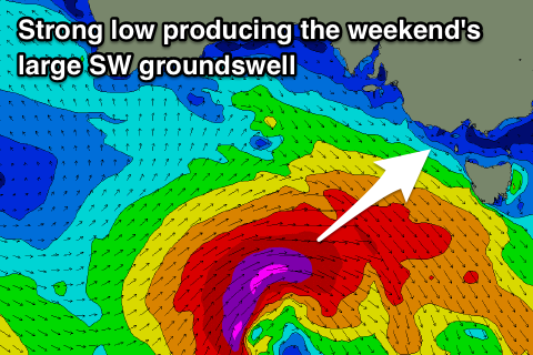
The models were undecided on the development of the low linked to this swell, but are now in alignment and we should see this low develop south of WA Wednesday night, with a great fetch of severe-gale to storm-force W/SW winds projected east towards Tassie.
A large long-period SW groundswell is expected, with it kicking late Friday but peaking Saturday morning to 4-6ft on the Surf Coast, 8ft on the Mornington Peninsula and with varying and improving winds. A dawn E/NE'ly is due to swing more N'th through the morning, holding early afternoon ahead of sea breezes. This won't great, perfect conditions but workable waves across selected breaks.
A N/NW offshore on Sunday will create straighter and cleaner conditions with easing 3-4ft sets on the Surf Coast, 5-6ft to the east.
Longer term another good W/SW groundswell is due early next week followed by a possible large swell mid-week as a strong node of the Long Wave Trough develops across the south-east of the country. More on this active start to autumn on Wednesday.
Comments
Once again...Excellent........!
At least this time were sharing somewhat... most likely 'that's what she said' over here
Hmmmm, is that way too non PC
I never understand the rating system Melb East yesterday 5/10?
It was just perfection, maybe some new glasses are in order.
Having been stranded on the Sunshine Coast for 5 weeks working with consistent onshore winds mixed into a short period windswell, except for 4 days of cyclone OMA, give me Victoria anyday!
And looks like a long weekend to look forward to ahh you’ve got to love it. Mental note ‘don’t get ahead of yourself, too much expectation only leads to misery’
Agree with you there Chris, Sunday was really fun and heaps of banks around. Happy enough to have the lowish rating, can you imagine how busy it could have been if it was given an 8/10?
Yes I do like the low rate days which if the right location picked then you get way over the forecast.
That being said though generally your call is made before you see a rating for a Melbourne based effort. So from my perspective it is usually just a comparison of the day not a beacon.
Hopefully this weekend is as good as the last.