Easing surf, small ahead of some larger swell later next week

Victoria Forecast by Craig Brokensha (issued Wednesday 4th January)
Sign up to Swellnet’s newsletter and receive the Victorian Forecaster Notes and latest news sent directly to your inbox. Upon signup you'll also enter the draw to win a surf trip to P-Pass for you and a mate. It doesn’t get much easier so click HERE to sign up now.
Best Days: East of Melbourne Thursday and Friday mornings, both coasts Saturday
Recap
Small onshore waves across the coast yesterday, while today a new inconsistent SW groundswell has filled in with 2-3ft sets across magnets on the Surf Coast, around 4ft to the east with a developing offshore wind. The beaches are fun and should be good until sea breezes kick in. The swell will also ease through the day.
This week and weekend (Jan 5 - 8)
Similar conditions are due tomorrow as a variable wind develops across both coasts through the morning, although the surf will be small.
The Surf Coast is only due to be 1-2ft max, while the Mornington Peninsula should see 3ft sets. Afternoon sea breezes will create bumpy conditions, so surf mid-late morning.
A low point in swell is due Friday morning and the Mornington Peninsula will be best again as a dawn SE'ly tends variable but with small 2-3ft sets.
Into the afternoon and more so Saturday morning, our new SW groundswell is due to fill in, produced by a relatively weak but sustained polar front traversing the shelf through today and early tomorrow.
A pre-frontal NW fetch is giving way to a better post-frontal W/SW fetch and we should see fun 2ft to nearly 3ft sets on the Surf Coast early Saturday, and 3-4ft+ waves on the Mornington Peninsula.
A N/NE offshore wind will create clean conditions on the Mornington Peninsula most of the day, and this may tend N/NW on the Surf Coast at times through the day.
Sunday will be small and a W/NW tending W/SW breeze won't leave many options with easing 1-1.5ft sets max on the Surf Coast.
 Next week onwards (Jan 9 onwards)
Early next week looks a little slow with small pulses of W/SW groundswell, but as talked about last updated, some better frontal activity is due to develop under the country through next week.
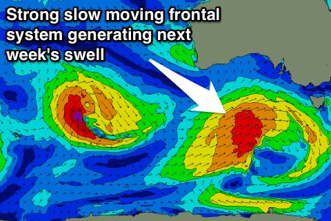
An initial small front will produce a small kick in acute W'ly swell Tuesday afternoon and Wednesday morning but of greater importance is a much broader and slow moving system firing up on its tail and reaching a peak in intensity south-west of us Tuesday.
A moderate to large sized W/SW groundswell is expected Thursday from this system, coming in around 4-5ft on the Surf Coast and 6-8ft on the Mornington Peninsula with a morning W/NW breeze.
Another swell may follow for the weekend, but we'll review next week on Friday.