Improving surf through Friday before sea breezes kick in

Victoria Forecast by Craig Brokensha (issued Wednesday 14th December)
Sign up to Swellnet’s newsletter and receive the Victorian Forecaster Notes and latest news sent directly to your inbox. Upon signup you'll also enter the draw to win a surf trip to P-Pass for you and a mate. It doesn’t get much easier so click HERE to sign up now.
Best Days: Friday mid-morning onwards both coasts, east of Melbourne Monday morning
Recap
Good clean 1-2ft waves across the Surf Coast yesterday morning and 3ft sets on the Mornington Peninsula with morning offshores ahead of a shallow W'ly change on the Surf Coast, tending variable again late and similar with sea breezes on the Mornington Peninsula.
Today, building SW windswell was coming in around 2ft on the Surf Coast and a messy 3-4ft on the Mornington Peninsula with an early W'ly around Torquay creating workable conditions.
Winds have since shifted S/SW and we'll see the swell continue to build through the day as a strong cold front clips the state.
This week and weekend (Dec 15 - 18)
Currently the strong front clipping the state is producing a broad and elongated fetch of W/SW gales through our south-western swell window and will continue to do so into this afternoon before moving off to the east this evening.
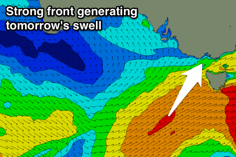 A moderate sized SW groundswell is due off this front, peaking tomorrow to a good 3-4ft on the Surf Coast and 5-6ft+ on the Mornington Peninsula.
Winds will be an issue though with a moderate to fresh S/SE tending SE breeze, leaving only a few select locations with decent conditions.
The swell should ease through Friday from 3ft on the sets across the Surf Coast and 4-5ft on the Mornington Peninsula with improving conditions.
A dawn E'ly breeze is due to tend more variable from the north through the day before mid-afternoon sea breezes kick in.
This should see the Surf Coast beaches offering good waves from mid-late morning, while the Mornington Peninsula should be fun from mid-morning.
Saturday will then be poor again with a fresh W/SW tending SW change and smaller surf. The Torquay region will likely see an early W/NW'ly.
This change should produce a small increase in SW windswell Sunday, mixed with an inconsistent SW groundswell from a small polar low over the coming days.
The low isn't looking too significant any more, with a small 2-3ft wave on the Surf Coast and 4-5ft sets on the Mornington Peninsula.
Winds will again be poor though with a S/SW tending S/SE breeze in the wake of Saturday's change.
Next week onwards (Dec 19 onwards)
Small easing surf but with offshore winds for the Mornington Peninsula is on the cards for Monday morning, while into next week similar swells are due with onshore winds.