Small swells this week with varying winds

Victoria Forecast by Craig Brokensha (issued Monday 5th December)
Best Days: East of Melbourne Wednesday morning, Surf Coast Saturday morning
Recap
A good weekend of swell with building W/SW energy through Saturday coming in around 3-4ft on the Surf Coast with the odd bigger set into the afternoon, although winds were best through the morning. The Mornington Peninsula built to a solid 6ft to occasionally 8ft before sea breezes kicked in.
Sunday morning saw the swell hanging in nicely with similar sized surf across both coasts and improving conditions. A late shift to NW winds on the Surf Coast created pumping waves for the late session.
Today the swell was much smaller along with an onshore change.
This week and weekend (Dec 6 - 11)
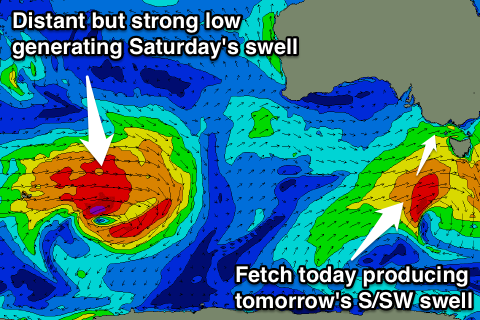
The strength of the fetch attached to today's change is slightly stronger than forecast on Friday, with a fetch of W/SW gales being generated just within our swell window south-west of Tasmania.
There isn't due to be any major size generated off this fetch still, with a kick to 2ft due on the Surf Coast tomorrow morning (possibly the odd bigger set at dawn at magnets) and 3-4ft+ waves on the Mornington Peninsula, easing through the day.
Winds aren't that ideal with a light to moderate SW'ly through the morning, increasing into the afternoon, and the chances of an early W'ly around Torquay is 50/50. Keep an eye on the local observations and Torquay surfcam for a small window.
 Wednesday will be much cleaner with a light N/NW offshore (tending N/NE before sea breezes on the Mornington Peninsula) but the surf will be weak and easing from 1-1.5ft on the Surf Coast and 2ft to maybe 3ft on the Mornington Peninsula.
A stiff N'ly wind is expected Thursday morning but with no swell, and a strong W/SW change is due through the middle of the day/early afternoon.
This change will actually shed off and race ahead of a swell produced by a stronger polar low that's currently south-west of WA.
A fetch of gale to severe-gale W/SW winds are being generated in our far western swell window, tracking east-northeast towards the Bight and away from us tomorrow before weakening and spawning the front on Thursday.
The front itself will aim a fetch of strong SW winds into us Thursday afternoon, kicking up a weak mid-period SW swell for Friday morning to 3ft+ on the Surf Coast and 6ft on the Mornington Peninsula but along with gusty SW winds.
The long-range W/SW groundswell from the low proper should build into the afternoon and peak Saturday morning to an inconsistent but strong 3ft (on the sets) on the Surf Coast and 4-5ft+ on the Mornington Peninsula.
Winds are looking better with a morning W/NW'ly around Torquay.
Longer term we may see some fun S/SW groundswell for Sunday afternoon and Monday but with average winds. More on this Wednesday.
Comments
Can you look in too your almighty crystal ball craig and take a stab at when the peninsula will see a consecutive two day period of days good surf. Critera being NE winds and 4ft+...
Sometimes you don't want the crystal ball to be consistently accurate.
I just want two days. I cant remember the last time and even if i begin too think of possibly potentially considering wondering about a THREE DAY BENDER, that i will be smited down on the very spot i stand.
Id be pretty stoaked if we even got 1 whole day of offshore 4ft+ atm
Certainly not in the last 8 months. Even last summer was average.
Looks like you'll get your wish Nick. Update soon.
Ey ladies and gents, It's been pretty tough lately ey. Not real consistent, but if you can pick the spot, time and day wisely your likely, with a bit of luck, to strike some liquid magic. . For example ( I'm totally not bragging, I'm not that guy) a couple of weeks ago I had probably the best session ever at a very well known rocky spot slaying 9/10 barrels with 4 others out, on a weekend, we got lucky. You can't always rely on Craig, Stu and the other legends at SW, weather and forecasting is a tough game I imagine. Good work fellas! Cheers, Deebs
killing it deebo
Good to see the S/SW swell punching a little above its weight.
Was a tricky call but good 3ft sets reported this morning.
Does that mean you will expect 2-2.5ft waves tomorrow morning or still 1-1.5ft on the surf coast Craig
Cheers
Nah I think it will be 1-2ft max tomorrow morning.
Dropping steadily and with weak periods..