Workable windows into the end of spring

Victoria Forecast by Craig Brokensha (issued Friday 25th November)
Sign up to Swellnet’s newsletter and receive updates on when the Victorian Forecaster Notes are looking better as well as the latest news sent directly to your inbox. Upon signup you'll also enter the draw to win a surf trip to P-Pass for you and a mate. It doesn’t get much easier so click HERE to sign up now.
Best Days: Surf Coast Saturday and Sunday mornings, both coasts Monday morning, east of Melbourne Tuesday and Wednesday mornings
Recap
 Poor onshore waves all day yesterday across most locations (Phillip Island escaped with a more variable morning breeze), while today conditions were clean around Torquay but the swell small and weak and only to 1-2ft.
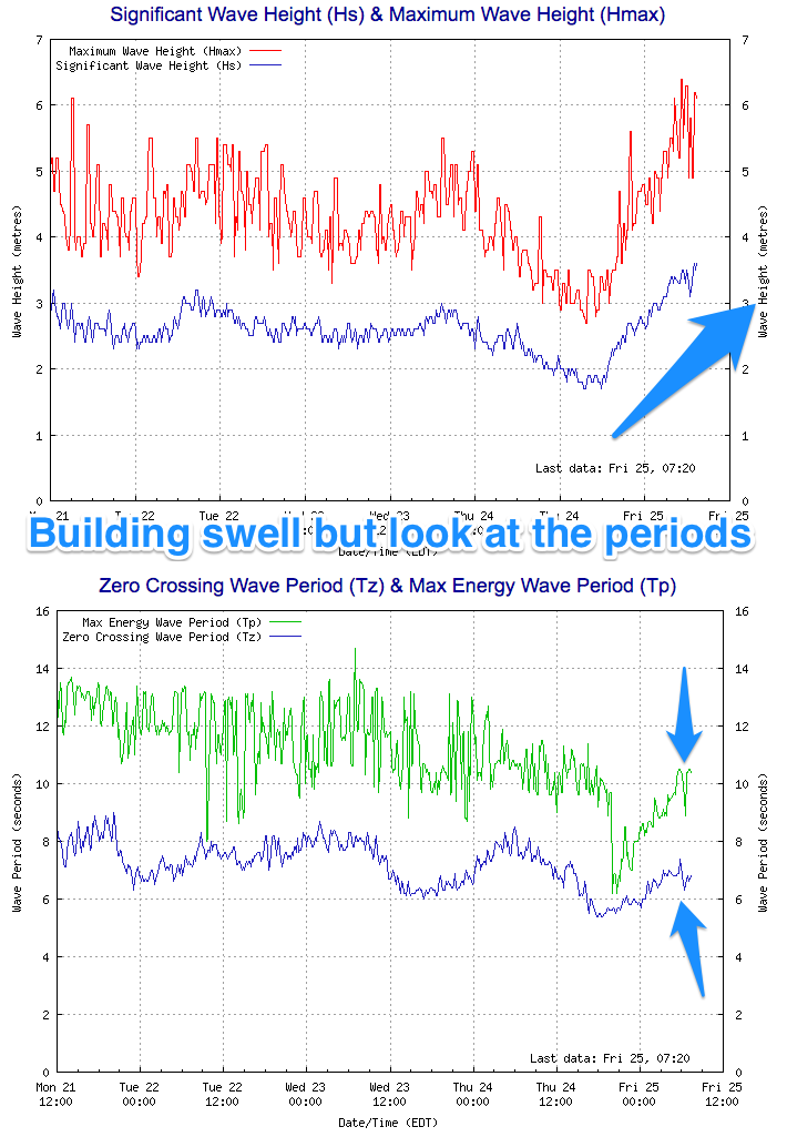
We should see an increase in size through day, but it will only be windswell, as confirmed by Cape Sorell readings (right) which are increasing but with average periods of 7s and peak periods of 10s.
This weekend (Nov 26 - 27)
The swell building over the weekend will be mostly mid-period energy, with the fronts generating it not reaching any major strength.
Currently a weak front is pushing up and into us, and this will be piggybacked by a secondary slightly stronger system this afternoon and tomorrow morning, generating the strongest pulse of swell for Sunday morning.
Size wise, tomorrow should be in the 2-3ft range most of the day on the Surf Coast, possibly kicking a little stronger later, with 4-5ft sets on the Mornington Peninsula.
Sunday morning will be better with consistent 3ft waves, possibly mixed in with the odd bigger one. The Mornington Peninsula should offer 5-6ft sets.
Conditions are looking good around Torquay tomorrow morning with a moderate W/NW offshore, tending fresh W/SW through the day, while Sunday looks similar but with lighter winds, more S'ly into the afternoon.
Next weekend onwards (Nov 28 onwards)
Sunday's swell should ease off through early next week, back from 2ft to maybe 3ft at swell magnets on the Surf Coast and 3-5ft on the Mornington Peninsula.
Conditions should be much better east of Melbourne as well with an early light offshore N/NE breeze, tending W'ly through the morning and then more onshore into the afternoon. The Surf Coast will also be clean all morning.
Tuesday looks as if it will be smaller again but winds are a little unclear with a small surface trough in the region.
More than likely we'll see variable winds, opening up a fun window east of Melbourne.
Leftovers are expected on Wednesday but with light offshore winds for exposed beaches.
Longer term there's nothing significant on the cards until maybe next weekend, with an intense mid-latitude low on the cards generating W/SW swell, but more on this Monday. Have a great weekend!