Another fun weekend, good days next week as well

Victoria Forecast by Craig Brokensha (issued Friday 16th September)
Best Days: Both coasts Saturday and Sunday morning, Surf Coast longer into Sunday afternoon, Surf Coast Monday, both coasts Tuesday morning
Recap
Excellent waves across the Surf Coast yesterday morning with a good new SW groundswell to 3-4ft and offshore winds. An onshore change moved in late morning creating poor conditions into the afternoon.
Today conditions were clean again on the Surf Coast but with easing 3ft sets. The Mornington Peninsula was OK but not great with a light NW breeze.
This weekend (Sep 17- 18)
The surf is expected to be smaller again tomorrow morning, with a mix of S/SW groundswell from a late forming polar low to our south, and also some small building W/SW groundswell.
It looks like the models are over-forecasting the size a little with 2ft+ waves due on the Surf Coast, maybe reaching 2-3ft into the afternoon, with 3-4ft+ waves on the Mornington Peninsula, increasing more to 3-5ft through the afternoon.
Conditions will be great with N'ly winds, tending locally offshore across most breaks.
Sunday's W/SW groundswell is still on track but expect long waits between sets. This swell was generated from Sunday evening through this week by a strong polar low firing up south-east of South Africa and traversing east to a position south-west of WA, and then weakening while approaching us.
The Surf Coast should see inconsistent 3ft waves, with possibly the odd bigger one at magnets (13th Beach etc), while the Mornington Peninsula is due to come in at 4-6ft.
Winds are still a little undecided for Sunday, with the models diverging on how fast a trough will move in from the west.
GFS has it quicker and with NW winds, giving into an early afternoon W/SW change. BOM 3 day however has N/NE tending NW winds ahead of a mid-late afternoon change. As this is higher resolution, I fell this is the way the weather will go, with good conditions early on the Mornington Peninsula, deteriorating from late morning. The Surf Coast will remain cleaner longer.
 Next week onwards (Sep 17 onwards)
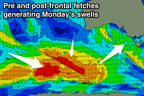
Our good new SW groundswell due into Monday is still on track, with two separate pulses due.
These swells are being generated by a pre-frontal fetch of W/NW gales, followed closely by post-frontal W/SW gales, with the first swell from the pre-frontal winds arriving for Monday morning, with the secondary swell for the afternoon.
The afternoon swell looks a touch bigger if anything than the morning swell, with the Surf Coast coming in at 3-4ft, with 5-6ft+ sets on the Mornington Peninsula. A morning W/NW breeze is due to tend variable into the afternoon and this will favour the Surf Coast.
A temporary drop in size is due through Tuesday under gusty morning N'ly winds ahead of another W/SW change through the afternoon.
This change will be linked to a second front piggy-backing over the back of the polar low generating Monday's swell, projecting a good fetch of W/SW gales towards WA and then through the Bight.
This will generate a good W/SW groundswell for Wednesday afternoon, kicking to 3ft+ on the Surf Coast and 5-6ft on the Mornington Peninsula. Winds are the only issue with a W/SW breeze due, but more on this Monday. Have a great weekend!
Also; be sure to check out the all new Lost Lands Music festival held over the Melb Cup weekend. The Waifs, Missy Higgins, Mariachi El Bronx and more. A festival for families and friends, with adult and children programming in equal measure. Swellnet peeps have access to the limited Lost Lands offer of buy 1 adult ticket and the child is in free saving $50 a kid. Get on it!! Click through here fore more details: http://swllnt.com/2aNC5iH
Comments
How's this random capture from the Torquay cam this morning.
Hi Craig,
Just inquiring bout the winds tomorrow .... the models I've looked at say W->SW winds, have the models you discussed above converged ?
Thanks, have a good weekend.