Good options on both coasts this week

Victoria Forecast by Craig Brokensha (issued Monday 15th August)
Best Days: Both coasts tomorrow, east of Melbourne Thursday, Surf Coast Saturday and Sunday mornings
Recap
A great weekend of waves on the Surf Coast with clean 2-3ft sets Saturday but Sunday was the day to hit the coast. A mix of new W/SW groundswells built through the day from 3-4ft early yo 4-6ft through the afternoon under all day offshores.
This morning the swell was back to 3-5ft on the Surf Coast with a touch more north in the wind, providing cleaner options to the east with excellent waves on Phillip Island.
This week and weekend (Aug 16 - 21)
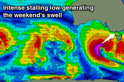
Our strong pulse of long-period W/SW groundswell for tomorrow morning is still on track, with satellite confirmation of 50kt core winds around the intense but east-southeast tracking low.
With a gradual drop in swell today, a kick back to 3-5ft tomorrow morning is expected and 6ft to occasionally 8ft on the Mornington Peninsula, easing steadily through the day. Local offshore N'ly winds will create clean conditions at selected breaks in both regions all day (tending more N/NW into the afternoon). Keep an eye on conditions across the Mornington Peninsula through the day on the Portsea Cam.
Wednesday will be a lay day as an onshore S/SW change is due just before dawn, creating poor conditions.
Smaller pulse of W/SW groundswell are due Wednesday afternoon and Thursday morning from weak mid-latitude westerly winds under and just south-west of WA.
 No major size is due, with easing 2ft+ sets expected Thursday morning on the Surf Coast and 3-4ft+ waves on the Mornington Peninsula.
Conditions will improve rapidly after Wednesday's change with an approaching low swinging winds back to the N/NE, strengthening through the day.
This low will be quite a significant cold outbreak with it deepening and developing south-west of us. A strengthening fetch of gale-force W/SW winds with stronger storm-force SW winds will be aimed at us from Thursday through Friday as the low stalls a little.
A moderate to large W/SW tending SW groundswell that will build later Friday and peak Saturday. The models are still moving around a little but a peak in the 6ft range is likely on the Surf Coast and 8-10ft on the Mornington Peninsula under NW tending SW winds. Easing surf is then due Sunday with similar winds. We'll have another look at all of this on Wednesday though.
Comments
How's this wave, between sets at Portsea? Almost worth the occasional flogging.
That's one heck of a closeout at 13th Beach.
Solid as fuck at porto, but cleanest ive seen in ages..
Top to bottom at Portsea this arvo!
Just got in from out there. That swell was relentless. Looking out now its stacked to the horizon. Literally hasnt stopped breaking
Jeez, would of been hard work yeah, any holding up with the tide?
There was a bit of reform. But yeah a bit of work for not much reward haha. Would of been nice if there was more lulls. Seriously, was out for hour an a half i could count on one hand how many breaks between sets. Good way to work off a big lunch.
The new swell this morning is looking great!
Defiantly bigger last night than this at peninsula
Tomorrow morning's onshore change has been delayed a litttle, with W/NW winds preceding it.
So the Surf Coast will be worth a surf at dawn, mind you smaller and around 3ft.