Fun run of surf at small wave swell magnets

Victoria Forecast by Craig Brokensha (issued Wednesday 3rd August)
Best Days: East of Melbourne from tomorrow through the rest of the period
Recap
A new W/SW groundswell yesterday but with fresh to strong onshore winds, leaving very limited options while today the swell was smaller as gusty S/SW winds continued.
This week and weekend (Aug 4 - 7)
Conditions will start improving from tomorrow, and for the rest of the period up until about Wednesday, smaller swells and winds from the northern quadrant will favour the Mornington Peninsula and Phillip Island.
Tomorrow, a reinforcing W/SW groundswell is due to fill in through the day, keeping the surf up from today, generated by a pre-frontal fetch of W/NW gales moving in from the Indian Ocean the last couple of days.
We should see this swell build to the 3ft to possibly 4ft range at spots exposed to the westerly swell on the Surf Coast, with 6ft sets on the Mornington Peninsula. The swell is then due to ease back from 3ft and 5ft respectively Friday morning.
Conditions will be best to the east of Melbourne tomorrow with an E/NE tending E/SE breeze, while Friday looks to see improving conditions on the Surf Coast through the morning as an early NE'ly tends more N/NW and then variable into the afternoon. Locations east of Melbourne look good all day as well with a N/NE tending variable breeze.
 There's nothing major due into Saturday with easing 1-2ft waves on the Surf Coast and better 3ft to occasionally 4ft sets on the Mornington Peninsula with local offshore tending variable winds.
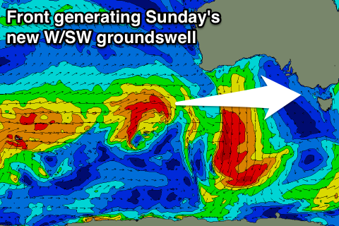
Sunday morning will start even smaller, but into the afternoon an inconsistent W/SW groundswell is due to fill in, produced by a strong but short-lived mid-latitude front pushing towards WA today, weakening tomorrow while passing under it.
The Mornington Peninsula and Phillip Island will be the best options for a surf, with a kick from 3ft early to 3-4ft through the day. The Surf Coast will be tiny, with 1-1.5ft waves into the afternoon.
Great conditions should continue with local offshore tending variable winds again.
Next week onwards (Aug 8 onwards)
Sunday's kick in W/SW swell is due to ease Monday under N'ly winds, with another inconsistent W/SW groundswell due for Tuesday from a broader but more distant frontal system firing up south-west of WA. The size off this system is similar to Sunday's with N/NE winds.
Longer term we'll have to rely on inconsistent WSW groundswell energy into the end of next week as the storm track remains focussed up towards WA, but more on this Friday.
Comments
Meanwhile down Moggs Creek..
Gary can't conjure up a double entendre for how ridiculous that is
Haha Patty D what the hell was that!
Ok. Ill build some houses while having sex. Understood. Cheers fox footy
Danger might be able to kick a footy but he has a hypto.