Surf Coast to end the week, different options for the weekend

Victoria Forecast by Craig Brokensha (issued Wednesday 4th May)
Best Days: Surf Coast Thursday and Friday, beaches and locations east of Melbourne Thursday, Saturday, Sunday and Monday
Recap
A bit of a slow start to yesterday with strong and tricky offshore winds and 2-3ft waves on the Surf Coast with larger sets on the Mornington Peninsula. The swell started to kick through the afternoon though but today was the day for the swell, with large long-period W/SW groundswell lines filling in across both coasts.
The Surf Coast is offering large pumping 6-8ft waves on the reefs (with a couple of bigger bombs), with large 10ft closeout sets on the Mornington Peninsula. The swell is still holding steady on the Cape Sorell wave buoy (6m @ 15/16s), and with this we should see similar sets continue into the afternoon as winds hold from the NW. Photos from this morning by Steve Arklay


This week and weekend (May 5 - 8)
From this evening we'll see the swell easing slowly across the state due to the fact that this wasn't just one single storm moving through our swell window, but a vast prolonged fetch of gale to severe-gale SW winds aimed through our swell window for a few days.
The Surf Coast should continue to provide 4-6ft sets on the exposed reefs, with 8ft waves on the Mornington Peninsula, easing back into the afternoon and then down further from the 4ft and 6ft+ range respectively Friday morning.
Our reinforcing W/SW swell for later Thursday and Friday morning doesn't look as good with the pre-frontal fetch of W/NW gales moving really fast through our swell window.
In saying this it will slow the easing trend a touch.
Conditions tomorrow will be great with a moderate to fresh N/NW'ly, while Friday will see NW tending W/NW winds.
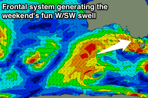 Into the weekend we'll see a new pulse of moderate sized swell filling in through Saturday and then easing Sunday. This will be generated by a strengthening polar front pushing up from under WA, towards the Bight this evening and then across towards us Thursday evening, persisting Friday.
Wave heights aren't expected to drop below 3ft on the Surf Coast Saturday morning, with a slight kick in size due through the afternoon to 3ft+ (4ft sets swell magnets), easing from a similar size Sunday morning. The Mornington Peninsula should be around 5-6ft Saturday morning, kicking to 6ft+ through the afternoon and easing Sunday.
Conditions will be better for the beaches with a N/NE tending variable breeze Saturday and then fresh N/NE winds Sunday.
Next week onwards (May 9 onwards)
The swell will continue to ease into Monday under offshore N'ly winds, with tiny surf Tuesday and less favourable strong NW tending W'ly winds.
Longer term we've got a couple of decent frontal systems due to move in through the middle of next week, generating a couple of fun pulses of moderate sized swell for later in the week, but we'll have a closer look at this Friday.
Comments
Will Phillips captured this cleanup bomb set at Bells. Carnage!
Ouch. Can almost observe the pooper-valves helping themselves to air!
2 tombstones in the whitewash haha
Yeah so heavy haha, gonna pop up and then get steamrolled again.
Sorell is still charging..
How's that bells bomb!