Workable waves, 'bombing low' swell for Monday

Victoria Forecast by Craig Brokensha (issued Wednesday 4th November)
Best Days: Monday both coasts, Tuesday and Wednesday east of Melbourne
Recap
A tricky to forecast swell yesterday came in on model forecasts with 3ft waves on the Surf Coast and 4-6ft sets on the Mornington Peninsula but with less than favourable winds which were lightest and best through the morning.
Today the SW groundswell is easing, mixed in with a building stormy SE windswell and winds are workable across selected locations of the Surf Coast and eastern end of the Mornington Peninsula. Size wise there's 2-3ft peaks on the Surf Coast and 3-5ft waves on the Mornington Peninsula, with winds now likely to hold from the E-E/NE all day, limiting the size of the windswell and keeping conditions workable at selected spots.
This week and weekend (Nov 5 - 8)
As winds take a more E/NE bias through today and this evening, the SE windswell will really drop away quickly into tomorrow, easing from 2ft+ across the Surf Coast, with no real size on the Mornington Peninsula. Instead inconsistent levels of background swell to 2ft+ is expected east of Melbourne, with the chance of the 3ft set into the afternoon as the fore-runners of a long-period SW groundswell fill in.
Winds are still a little tricky to forecast but light E/SE breezes should swing E/NE through the morning, and possibly N'ly before tending variable into the afternoon.
Unfortunately Friday's onshore SW change due around dawn is still on the cards, ruining a good mix of building SW groundswells.
The Surf Coast is due to kick to a messy 3ft+ with 6ft sets on the Mornington Peninsula, easing back from 3ft and 5-6ft respectively Saturday morning. An early W/NW'ly is now likely Saturday morning, favouring the Surf Coast, before shifting SW late morning.
Sunday is looking fun across both coasts as wind tend variable and likely locally offshore with easing 2ft to sometimes 3ft waves on the Surf Coast and 4-5ft sets on the Mornington Peninsula.
 Next week onwards (Nov 9 onwards)
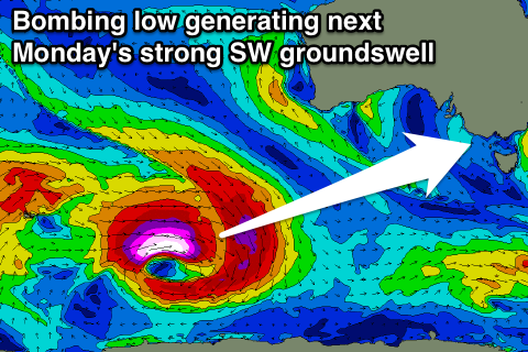
Monday's strong and powerful long-period SW groundswell is still on forecast, with a surface low drifting off of South Africa now currently being absorbed into the westerly storm track as it tracks south-east.
This will result in the low re-intensifying, with it 'bombing' as it drops well over 24hPa in a 24 hour period from 980hPa down to 932hPa.
As the low 'bombs' a pre-frontal fetch of severe-gale NW winds will then be closely followed by a stronger storm to hurricane-force fetch of W/SW winds to the south-west of WA.
The low will weaken south of WA, leaving a strong but inconsistent SW groundswell to travel towards us.
The long-period forerunners in the 23s range should show at Cape Sorell Sunday afternoon (without any major size), with the bulk of the swell filling in Monday afternoon across Victoria, peaking at 3-4ft+ on the Surf Coast and 6ft to occasionally 8ft on the Mornington Peninsula (smaller early).
Conditions are looking great through the morning as the swell builds with local offshore winds, tending variable through the early afternoon ahead of weak sea breezes. So there should still be some quality waves on offer into the afternoon as the swell peaks.
The swell should drop steadily into Tuesday, but there's plenty of fun reinforcing W/SW swell due into Tuesday and Wednesday. Unfortunately another deepening inland surface trough is due to bring strengthening S/SE tending E/SE winds through Tuesday and Wednesday, but more on this in the next update.
Comments
Need to give dan who does surf report for morn pen at rye to put his magnifying glass away when reporting.
2:56PM Afternoon report: Conditions have improved since this morning with E'ly winds backing off a touch. We have fairly clean and easily rippable peaks in the 3-4ft range, particularly at the more protected southern ends. Worth a look.
No. Just no. Peaky yes. 3-4ft nooooo.
Nothing personal. Just one time too many
I check the surf after work 95% pf the time and i do my usual online checks en route just out of infomation gatthering habit and it just sucks that little bit when you rock up expecting more as you assume theres a bit more going on. Ive learnt to read between the lines of the surf report aka deduct 1-2ft off report for the 4-6ft range and genrally 1 sometimes 2ft for the 1-3ft range.
Again. Nothing personal. Just one time too many.
agreed nick
sometimes I think they are using Hawaiian type measurements eg double overhead is what id call 4ft !
Monday's long period swell not really showing on the models yet?
Nah, it's showing, looking to kick strongly Monday afternoon, and yes better aimed under Tassie, but still strong for Victoria and South Australia.
Most of it heads south of tassie btl