Average week, possibly great Saturday

Victoria Forecast by Craig Brokensha (issued Monday 15th June)
Best Days: Tuesday east of Melbourne, Surf Coast for keen surfers early Wednesday, possibly Friday morning and Saturday
Recap
Great weekend of waves across both coasts, biggest and best east of Melbourne under generally favourable winds and with a slowly easing SW groundswell.
Today the swell has bottomed out with tiny waves across the Surf Coast and 3ft to occasionally 4ft waves on the Mornington Peninsula under light, local offshores early. Winds have since picked up from the NE, creating average conditions west of Melbourne.
This week (Jun 16 – 19)
As touched on the last few updates, there's nothing to really get excited about this week with small to tiny amounts of swell and now poor winds from Wednesday.
If you're looking for a surf, tomorrow and early Wednesday are your best bet at this stage.
Tomorrow is expected to be a touch bigger than today, with tiny 1ft+ waves on the Surf Coast and 3-4ft sets on the Mornington Peninsula (more into the afternoon) and winds will be best for locations east of Melbourne during the morning with a E/NE'ly, while variable breezes into the afternoon will favour also the Surf Coast.
A slight better SW groundswell pulse is due Wednesday to 1-2ft on the Surf Coast and 3-4ft+ on the Mornington Peninsula and the morning should see favourable light NW winds early across both coasts before a surface trough moves east, bringing a fresh to strong S'ly change.
This change will kick up some poor windswell into Thursday and Friday from the S'th tending SE with fresh S/SE winds through. This is unfortunate as a long-range and strong SW groundswell is due to be in the mix, peaking through the afternoon
This swell and the windswell are due to ease through Friday from 2-3ft on the Surf Coast and 4-6ft on the Mornington Peninsula and winds may ease and tend variable, creating workable conditions across both coasts during the morning before a S'ly kicks in again.
This weekend onwards (Jun 20 onwards)
The blocking pattern is expected to break down into the weekend and with this we should see more action into next week.
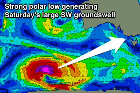
But before this, a strong pulse of SW groundswell is due Saturday across the state, generated by a very strong polar low firing up south-west of WA and then pushing slowly east through our swell window during this week. Winds will be in the severe-gale range with storm-force core winds when it first develops, generating a large and powerful SW groundswell for Saturday.
The Surf Coast should see 5-6ft surf with 8-10ft sets on the Mornington Peninsula under what look to be light variable winds, but we'll have a closer look at this on Wednesday as the models are still moving around regarding the funky surface trough across South Eastern Australia.
Comments
Jeepers Craig,
Saturday looks like it could be pumping, just wondering what Sunday and Monday are looking like at the moment
Cheers
Generally easing swell with strengthening N'ly winds at this stage.
Thanks Craig
How strong will the winds be
Early stages, but not too bad Sunday, becoming trickier Monday.