Fun Surf Coast Saturday, large and onshore from Sunday

Victoria Forecast by Craig Brokensha (issued Friday 17th April)
Best Days: Saturday on the Surf Coast, Sunday super protected spots
Recap
Tiny poor waves yesterday with onshore winds, while today a strong mix of new W/SW groundswells are building across the coast with light winds. The Surf Coast was in the 3ft+ range with 4-6ft sets on the Mornington Peninsula and we should see the swell reach 3-4ft and 6ft to occasionally 8ft respectively into this afternoon.
 This weekend and next week (Apr 18 - 24)
Tomorrow will be great across the Surf Coast and average on the Mornington Peninsula as this afternoon's increase in W/SW groundswell eases from 3ft+ and 6ft+ respectively under moderate to fresh NW tending W/NW winds ahead of a late SW change.
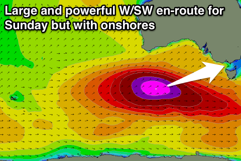
Sunday's large, powerful and dangerous W/SW groundswell is still on track, with the broad and intense polar low generating the swell currently positioned just south of WA, aiming a fetch of storm-force W/SW winds through our swell window. This low will push east towards us through tomorrow while weakening slightly and then pushing across us Saturday evening.
The Surf Coast is looking to come in at 6-8ft across most breaks with 10ft+ bomb sets at Bells and Winki while the Mornington Peninsula should see large 10-12ft surf.
Unfortunately conditions will be poor with a fresh to strong S/SW'ly tending S'ly breeze leaving protected locations with the only decent conditions. An early W'ly is still a slight possibility around Torquay but it won't be worth the drive from Melbourne.
The swell should drop through the afternoon and then further through Monday, although a reinforcing SW groundswell for Monday morning generated on the backside of the low will slow this trend.
Unfortunately winds will remain onshore and from the S/SE but much lighter with easing 4-6ft sets on the Surf Coast and 6-8ft+ waves on the Mornington Peninsula.
Tuesday and Wednesday will remain average with a SE'ly and S/SE'ly breeze respectively as the swell steadies with a small to moderate SW groundswell filling in. This persistent onshore wind will be due to an intense surface trough and possible East Coast Low forming off the NSW coast and will dominate our local winds for most of next week.
The next increase in considerable swell is due later Thursday and Friday, that being an inconsistent long-range SW groundswell. This will be generated by a series of strong polar fronts firing up in the Heard Island region this weekend, continuing east closer towards us next week while maintaining strength.
A series of good SW groundswell pulses should be generated with the size hovering around 3-4ft on the Surf Coast and 6ft+ on the Mornington Peninsula but with what looks to be dicey winds. We'll have a closer look at this on Monday though. Have a great weekend!