Fun Friday/Saturday, large and onshore Sunday

Victoria Forecast by Craig Brokensha (issued Wednesday 15th April)
Best Days: Friday both coasts, Saturday Surf Coast, Sunday protected spots, Tuesday both coasts
Recap
Small clean fun waves across the beaches to 2ft all day on the Surf Coast and 3ft+ on the Mornington Peninsula with all day offshores.
Today the surf was back to the tiny size range on the Surf Coast, with small and inconsistent 2ft sets east of Melbourne.
 This week (Apr 16 - 17)
Tomorrow is still looking to be a lay day with only a slight kick in swell and onshore W/SW tending SW winds across the Mornington Peninsula and early W/NW tending SW breeze on the Surf Coast.
Come Friday a mix of good W/SW groundswell pulses are due to fill in, the largest through the afternoon.
These swells have been generated by a series of vigorous polar lows firing up initially in our far swell window, and then in a better position to the south-west of WA.
Friday morning is expected to start out really slow with inconsistent 2-3ft sets on the Surf Coast and 4-6ft waves on the Mornington Peninsula but a bigger increase in size is due to arrive through the morning, building to 3-4ft on the Surf Coast and 6ft to occasionally 8ft on the Mornington Peninsula.
Winds should be light and variable through the morning creating clean conditions across both coasts, with weak E/SE sea breezes into the afternoon.
This weekend onwards (Apr 18 onwards)
Friday afternoon's increase in W/SW swell should hold a similar size into early Saturday before easing through the day. We may see a late increase in strong W/SW groundswell due Sunday but winds will be onshore anyway with morning and fresh N/NW winds due to give into a strong W/SW change late afternoon.
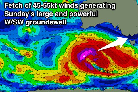
Sunday's large and powerful W/SW groundswell is one of the biggest we've seen in a while, with a strong node of the Long Wave Trough moving in from the west, spawning a very broad, intense and vigorous polar low.
A fetch of severe-gale to storm-force W/NW and then W/SW winds will be generated through our swell window, producing a large, long-period W/SW groundswell for Sunday coming in at 6-8ft on the Surf Coast with larger bombs due at Bells and Winki with 10-12ft sets on the Mornington Peninsula.
Conditions will unfortunately be poor with later Saturday's change expected to remain fresh from the S/SW into Sunday, with only a small chance of early W'ly winds at dawn around Torquay.
Come Monday the swell will be easing but from a large size-range as a reinforcing SW groundswell generated on the back side of the polar low peaks early Monday. Winds unfortunately look to linger from the S/SE across both coasts but without much strength. The Surf Coast should be easing from 4-6ft with 6-8ft+ sets on the Mornington Peninsula.
Tuesday should see a lighter and more variable breeze as the swell continues to ease.
Longer term we may see some later in the week, but we'll review this again on Friday.