Fun Surf Coast over the coming period

Victoria Forecast by Craig Brokensha (issued Wednesday 25th March)
Best Days: Thursday Surf Coast, early Friday around Torquay for keen surfers, Saturday/Sunday/Monday Surf Coast
Recap
Poor conditions yesterday with a moderate mix of SW groundswell and building windswell through the day with strengthening onshore winds.
The mix of swells has held in better than expected across the Surf Coast this morning with 3ft sets under offshore winds, while the Mornington Peninsula was a bumpy 4ft or so and in line with forecast expectations.
 This week (Mar 26 - 27)
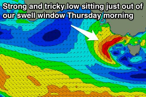
Our tricky and complex finish to the week hasn't got any easier, but in short, the Surf Coast will be the best bet tomorrow, with average surf across both coasts on Friday (besides a small window early around Torquay).
Firstly, a good new SW groundswell is due to fill in across the state tomorrow morning, generated earlier this week by a strong polar frontal system south-west of WA.
While a touch inconsistent the Surf Coast should build through the morning to 3ft before lunch, with the odd bigger set likely at Bells/Winki (smaller early) while the Mornington Peninsula should build to the 6ft range by mid-morning.
The models have come into alignment regarding the stalling mid-latitude low to our west through tomorrow, and they've gone the way of my forecast on Monday, that being that the low will stay further west and a touch too north to generate any decent swell for us until late tomorrow afternoon/evening, with a solid but junky windswell due into Friday.
Size wise I don't think we'll see the Surf Coast really get much bigger than what's expected from the SW groundswell tomorrow, with maybe the odd bomb set into the late afternoon/evening. Winds will be fresh and gusty from the NW most of the day, strengthening from the W/NW later towards the evening.
So the protected reefs are looking good from mid-morning onwards.
Friday should be bigger and in the 3-5ft range with 6-8ft sets on the Mornington Peninsula but along with strong and easing SW winds. The Torquay region should see a morning W'ly but the swell will be quite raw and not perfectly lined up.
This weekend onwards (Mar 28 onwards)
Friday's mix of swells will back off into the weekend, but a flurry of strong but unfavourably aligned frontal activity pushing through our swell window through the end of this week should produce fun levels of SW groundswell for Saturday, easing Sunday.
The fetches will be W/NW and aimed more towards the polar shelf, but we'll still see moderate amounts of SW groundswell spreading up radially into us.
This should keep 3ft sets hitting the Surf Coast Saturday, easing from 2-3ft Sunday morning with 5-6ft waves on the Mornington Peninsula Saturday, easing from 4-6ft Sunday.
Conditions will remain average across the Mornington Peninsula with onshore winds, but the Surf Coast should see a morning W/NW'ly Sat morning before shifting S'ly through the day. Sunday looks great on the Surf Coast with a NW tending W/NW breeze ahead of mid-late afternoon onshores, while the Portsea and Flinders areas will be best on the Mornington Peninsula with an early N/NW breeze.
Later Sunday we may see a late pulse of good W/SW groundswell but Monday morning will offer the most size when the swell peaks.
The source of this swell will be a strengthening polar front developing south-west of WA, racing in towards us while generating a fetch of gale to severe-gale W/SW winds.
The speed it races in at isn't ideal but the wind direction and its position in our swell window is great. This should result in a moderate sized W/SW groundswell for Monday coming in at 3-5ft on the Surf Coast and 6-8ft+ on the Mornington Peninsula.
Conditions will be best west of Melbourne again with offshore NW winds ahead of a S/SW onshore into the afternoon, while Tuesday will be better to the east with more variable breezes due as a secondary pulse of SW groundswell fills in. We'll have a closer look at this on Friday though.
Comments
Hey craig
do you think that the surf on monday morning will be good at crunchie pt at westerport
thanks heaps
Hey Lachie, yeah there should be fun 2ft+ waves through the morning before the tide starts to head out.
Looks like the swell is just squeeking in past Cape Otway this afternoon from the low stalling to the west. Solid sets reported at Bells/Winki.
Here's the satellite observations showing how hard it is to call the swell getting in from these systems..
Fetch just in swell window this morning..
Well that escalated quickly Craig. Being in the water most of the day, what was distinct was the long lines - real long - earlier around 2-3ft with an offshore that could blind; then when the rain came over and the very high tide was in, considerably more size and quite clean faces. Lots of current. Did such clean long lines come from the low which developed very close to us? That seems unusual, as other close lows have delivered raw, bumpy, all-over-the place swells. Or is it from a groundswell originating much further away? I note the primary and secondary swell for tomorrow are from almost the same direction, but the secondary is 13s wheras the primary only 9.
All from the low, but it would of sorted itself out as it wrapped in around Cape Otway. It wasn't generated right in Bass Strait, hence the good straight lines, tomorrow will be really mixed and totally different.
This is the proof, Cape Sorell which is south of the fetch from the low, but picks up any W/SW-SW groundswell didn't budge all day. So all from that fetch of 35-45kt winds directely west of Cape Otway.
Wow thanks for the explanation Craig. That makes it a pretty unique phenomenon then. You should have seen how dark it went just before the rain went over. Beaut, close rainbows over the surf as well. Magic.
Yeah, you don't get too many of these setups through the year.
But regarding the swell sorting itself out over such short distances, I was astounded when I moved to the East Coast that you'd see a swell generated right off your doorstep, say a few hundred kilometres to the south, and it would come in as strong straight lines of organised swell if the winds were locally offshore.
I would of imagined it to be all mixed up, close-spaced and a shambles, but over that small stretch of ocean it totally organises itself.
How was the wait between sets VJ? Like ya typical groundswell?
Some good waves this arvo, very straight but very inconsistent. Maybe 20 mins between a single set or a flurry. Plenty of waves in the sets though. A good classic all day offshore.
Yeah mitch the wait felt like a typical groundswell for Thurs arvo. Some big gaps, I dunno, I'd put at 5mins later in the day, perhaps more earlier, sometimes that would give you enough time to look to horizon and see it pretty flat. Then the sets would come, maybe about 3-5 in a set and sometimes two sets would arrive close together. Waves seemed to be more consistent on the high tide late in the day. Took a couple of beautiful pics, but I have no idea how to post photos and the spots... well, they don't exist anyway.
Craig I agree when I first saw the way East Coast swells could generate such beaut clean surf so close I was pretty blown away. On a truly lucky day there's no wind and the rain falls vertically, making the surface of the water look like velvet. Love those days. Still froth for those ECL days. Vicco is SW influenced and gets a majority of its swell in a similar fashion to WA, but those rare days do remind me of NSW/QLD a bit. In WA, I'd get amped for the NW wind before a big front, that would sometimes produce an angled groundswell that made the usually closing out beachies into a mini version of the Goldy points - but that was a really rare pattern that produced a NW fetch long enough to do this.
Friday was smaller than I anticipated, and still pretty clean but much more bumpy & rips were in effect and reversing themselves every 20 minutes or so.