Fun waves for most of the week

Victoria Forecast by Craig Brokensha (issued Monday 16th March)
Best Days: Tuesday morning exposed breaks, Wednesday and Thursday mornings both coasts, Friday midday onwards before the change hits on the Surf Coast, Sunday both coasts
Recap
Great waves Saturday with an easing swell from 3ft and 4-6ft respectively under offshore winds across both coasts through the morning ahead of a mid-afternoon onshore change. The change was stronger than expected into Sunday and with this a stormy and junky windswell kicked up across both regions but with no quality.
Today the swell was on the ease under better E/NE winds, favouring locations east of Melbourne.
 This week (Mar 17 - 20)
The surf will become small to tiny tomorrow as today's swell continues to ease, and exposed breaks will be the pick under N/NE breezes.
A late kick in new S/SW groundswell may be seen, generated over the weekend by a strong polar low pushing along the Antarctic Shelf.
This swell is expected to peak Wednesday morning to an inconsistent 3ft on the sets across the Surf Coast and 4-6ft on the Mornington Peninsula early, dropping off through the day.
The Surf Coast will be clean with a NW tending W/NW breeze, while the Mornington Peninsula should see a straighter N/NW'ly early.
Thursday looks good across both coasts but with a small easing 1-2ft wave on the Surf Coast and 3ft+ sets on the Mornington Peninsula under local offshore breezes (N/NW Surf Coast, N/NE Mornington Peninsula).
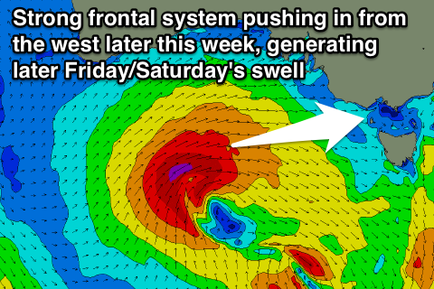
As touched on last update, a strong frontal system is forecast to push in from under WA and then towards us through the end of the week.
This front will begin south-west of WA initially, projecting a fetch of W/SW gales through our far swell window before pushing through the Bight Wednesday evening, followed by a secondary intensification to our west Thursday, aiming an additional fetch of gale to severe-gale W/SW winds into us.
This should result in two pulses of separate W/SW groundswell that will arrive at similar times, that being through the day Friday, kicking strongly through the afternoon/evening, peaking early Saturday and easing through the day.
The Surf Coast should build from a small 2ft or so Friday morning to 3-5ft by dark, peaking Saturday morning in the 4-5ft range. The Mornington Peninsula will be much bigger with the westerly swell direction, kicking to 8ft later Friday and easing from 8ft+ Saturday morning.
Winds will be poor though when the swell kicks with a strengthening W/NW'ly Friday ahead of a mid-late afternoon W/SW change and then moderate to fresh S'ly winds on Saturday.
Sunday looks much better under N/NE winds but the swell will drop quickly from 2-3ft on the Surf Coast and 4-6ft on the Mornington Peninsula.
Longer term we've got some new groundswell on the cards for early next week, but we'll have another look at this on Wednesday.
Comments
Hi Craig,
Just wondering if you able to tell yet if there are any signs of big swells coming to Victoria for the 2 week holiday period coming up
It's a little too far out to call at this stage. This time next week we'll have a much better idea.