Surf Coast to end the week, all locations Saturday

Victoria Forecast by Craig Brokensha (issued Wednesday 1st October)
Best Days: Thursday and Friday mornings west of Melbourne, Saturday everywhere, Monday east of Melbourne
Recap
Yesterday morning was excellent across the Surf Coast as the swell pulsed a little stronger than expected out of the W/SW during the morning to 4ft across most breaks, with 5ft sets developing at Bells and Winki under fresh N/NW winds.
Winds strengthened to the gale-force range around midday though before swinging W'ly, creating average conditions into the afternoon.
Today the largest pulse of W/SW groundswell has filled in to 4-6ft around Torquay and 8ft+ on the Mornington Peninsula but fresh W'ly winds created OK but less than perfect conditions on the Surf Coast, while everywhere else was a mess. We should see the swell back off a touch this afternoon as winds swing W/SW-SW.
This week and weekend (Oct 2 - 5)
This morning's large W/SW groundswell will drop away through this afternoon and further through tomorrow, down from 3-5ft on the Surf Coast and 6ft to occasionally 8ft on the Mornington Peninsula.
Winds will be good across the Surf Coast again through the morning with a W/NW'ly ahead of a shift to the W/SW late morning, so surf early for the biggest and best waves.
Our good pulse of S/SW groundswell due Friday is still shaping up nicely, with a deep polar low expected to form south-west of Tassie during today and project a broadening fetch of severe-gale to storm-force SW winds up towards Tassie and then on towards New Zealand (generating a very large swell for Cloudbreak on Monday).
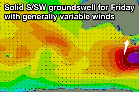 We should see medium levels of S/SW groundswell energy spreading up radially off this fetch, arriving Friday morning and pulsing to 3-5ft at all breaks on the Surf Coast with 6ft to occasionally 8ft sets on the Mornington Peninsula.
The only issue are the local winds and they should be favourable and light NW on the Surf Coast, but lingering light onshore to the east. More variable winds across both coasts during the middle of the day should create good conditions before a SE'ly kicks in.
Saturday should be great across both coasts with local offshore winds from the northern quadrant as the S/SW swell eases from 3ft to occasionally 4ft and 5-6ft respectively.
Sunday unfortunately looks dicey with an early onshore change likely, swinging S'ly into the afternoon with small-moderate amounts of swell.
Next Monday onwards (Oct 6 onwards)
An unfavourably south-east tracking but strong low pressure system from the Southern Indian Ocean is expected to produce a small pulse of W/SW groundswell for Monday morning. The Surf Coast should offer infrequent 2-3ft sets Monday morning with 4-5ft waves on the Mornington Peninsula with N/NE winds favouring spots east of Melbourne.
Longer term we may see a vigorous mid-latitude low firing up under the country as it approaches us mid next week, generating moderate to possibly large levels of W/SW swell, but we'll keep an eye on this.