Surf Coast Saturday, limited windows from Sunday onwards

Victoria Forecast by Craig Brokensha (issued Friday 27th Jun)
Best Days: Saturday on the Surf Coast and protected spots east of Melbourne, early Sunday for keen surfers around Torquay, early Monday/Tuesday around Torquay, Wednesday morning
Recap
Large levels of W/SW swell continued through yesterday as protected locations offered the best conditions with a fresh to strong W/NW wind.
A stronger W/SW groundswell filled in overnight and has offered great 6ft waves on the Surf Coast this morning with strong N/NW winds and 10ft sets on the Mornington Peninsula. The swell should ease through the day as winds persist from the N'th.
This weekend (Jun 28 -29)
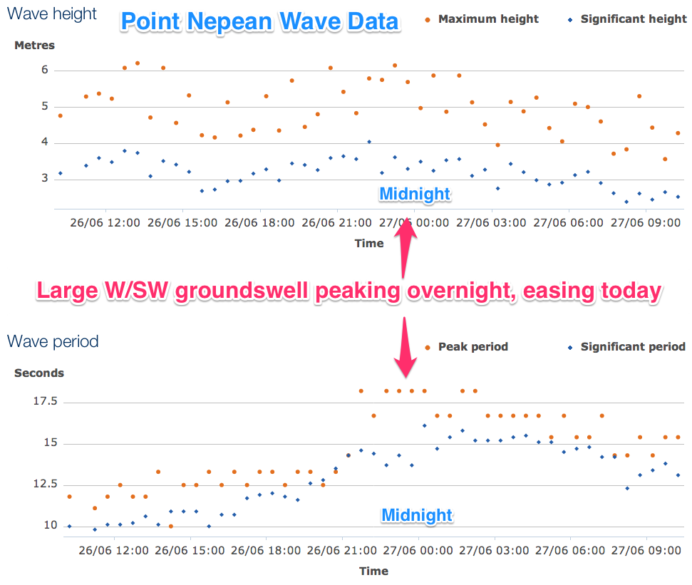 The vigorous frontal system responsible for today's swell, pushed under Tassie last night and with this we'll see the swell ease this afternoon and further into tomorrow.
The Surf Coast should see 3ft+ sets early with larger 5-6ft+ sets on the Mornington Peninsula under fresh and gusty N/NW winds.
Make the most of the clean fun waves tomorrow though as Sunday will be a write-off as a strong mid-latitude front pushes in across SA and then across us Sunday morning.
This system will bring with it fresh dumps of snow, but with strong winds and blizzardy conditions along with a medium-large increase in short-range SW swell to 4-5ft+ across the Surf Coast and 8ft on the Mornington Peninsula but with strong SW winds. The Torquay region may see an early period of W'ly winds but it won't be worth the drive from Melbourne.
Next Monday onwards (Jun 30 onwards)
Sunday's SW groundswell should ease off into Monday morning with an early W'ly again around Torquay but onshores everywhere else.
An afternoon kick in new SW swell is due though as another cold front pushes up into us through the day, with Tuesday expected to offer good 3ft waves on the Surf Coast and 4-6ft sets on the Mornington Peninsula as winds play out similar to Monday.
There's nothing significant on the cards until later in the week with easing swells and NW winds. We may see a new W/SW swell arriving later Friday but a better SW groundswell is lining up for the weekend and we'll discuss this in more detail on Monday.