Tiny start to the weekend, better Sunday and great Monday onwards

Victoria Forecast by Craig Brokensha (issued Friday 9th May)
Best Days: Sunday on the Surf Coast, Monday, Tuesday, Wednesday, Thursday
Recap
The Mornington Peninsula and Surf Coast beaches provided the best waves yesterday with an easing swell from 2-3ft and 4ft respectively under N-NE winds.
Today the swell is bottoming out across both coasts with tiny 1ft waves on the Surf Coast and 2-3ft sets on the Mornington Peninsula under a stronger N/NE wind. Winds should hold from the N'th all day as the swell continues to ease.
This weekend (May 10 - 11)
Tomorrow will remain tiny to flat on the Surf Coast while the Mornington Peninsula should offer the odd inconsistent 2ft set, but fresh N/NW tending NW winds will only favour locations towards the western end of the peninsula. Beginners on the Surf Coast should head to 13th Beach or Fairhaven.
A new W'ly swell is due on Sunday but this westerly direction will limit size on the Surf Coast to 2ft around Torquay, while 13th Beach should see 3ft sets. The Mornington Peninsula should see more size to 4-5ft+ but a NW tending SW breeze will favour the Surf Coast. The source of this swell was a mid-latitude front slipping south-east across WA before pushing through Bass Strait, generating a fetch of strong to gale-force W/SW winds while continuing to slip south-east. This unfavourable track is responsible for the westerly direction and large difference in expected size.
Monday onwards (May 12 onwards)
There's been no real change to the two long-range W/SW groundswells expected across the coast later Sunday and more so Monday afternoon.
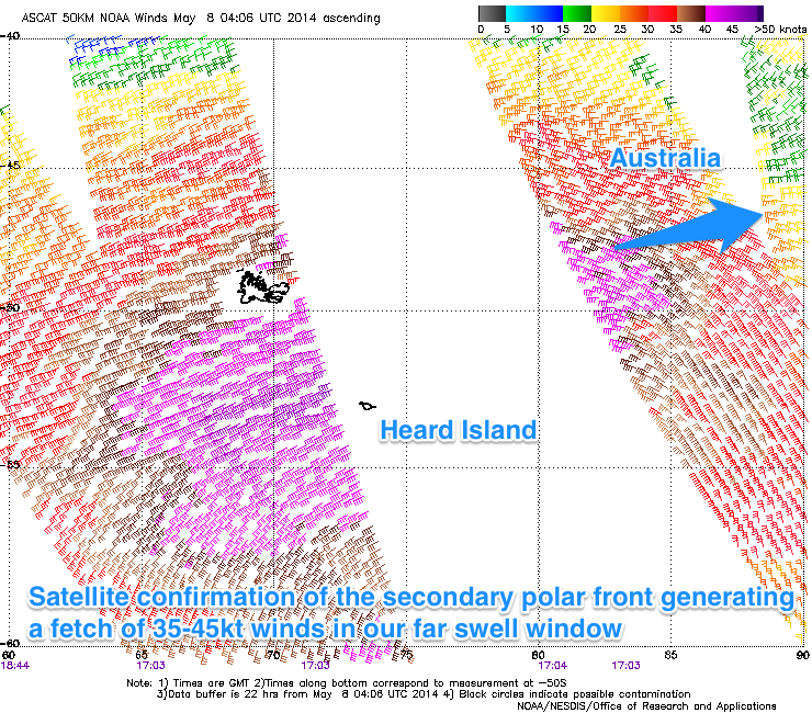 Satellite observations confirm two broad fetches of 35-45kt+ one after the other in the Southern Indian Ocean (pictured right), setting in motion two distinct pulses of swell. The first due to show size later Sunday probably won't be see under the W'ly swell, but come Monday the stronger pulse should fill in and reach a very inconsistent 3-4ft on the Surf Coast and 6ft to occasionally 8ft on the Mornington Peninsula during the afternoon.
Winds on Monday morning as the swell starts kicking should be favourable and variable (tending locally offshore) before swinging more E/SE during the day.
Tuesday looks much better with moderate offshore N/NW winds on the Surf Coast and N/NE winds east of Melbourne before tending variable into the afternoon. Size wise the swell should ease from a similar size to Monday afternoon owing to a flurry of strong mid-latitude frontal activity south-west of WA, buffering the easing trend.
Through the rest of the week we are expected to receive medium levels of W/SW groundswell under favourable winds. The reason for this is a strong blocking high over the continent in conjunction with a relentless series of polar fronts firing up towards WA before being deflected back the south-east by the high.
Size wise, the Torquay region should persist in the 3ft range on the sets with occasional bigger days at 13th Beach (likely Wednesday morning and Thursday afternoon) with 6ft waves on the Mornington Peninsula.
This pattern will break down during next week though, with a slow drop in size through next weekend. Winds as touched on above should be favourable for the most part with N/NW winds Wednesday and Thursday morning before shifting more NW. We'll review this again on Monday though. Enjoy the weekend!
Comments
Hi guys I have just noticed today that the swell period is down to 16 sec from the original 19 sec for monday...
I've just had this picture in my head all week of swell lines straight as a ruler. ...but 16sec is still a very good period for clean straight surf still.......