Powerful weekend out of the south, then a quiet patch

Sydney Hunter Illawarra Surf Forecast by Ben Matson (issued Friday Dec 10th)
Forecast Summary (tl;dr)
- Large swell combo for the weekend, best conditions early morning
- Solid, easing S/SE swell Mon with light winds, smaller Tues though still fun with clean conditions and light winds
- Not expecting much, if any NE swell from the weekend's cyclone developing in the Coral Sea
- Very small surf expected Wed onwards, nothing significant into the long term at this stage
Recap
Early light winds Thursday morning freshened from the south through the middle of the day, with a small combo of E’ly and S’ly swells maintaining 1-2ft waves at most open beaches. A developing low off the Far South Coast has strengthening E/SE tending S/SE then S/SW winds in that region since Thursday dinnertime; Point Perpendicular recording 59kts around 2pm today, Montague Island recording 55kt gusts and around 7am, Jervis Bay Airfield recording 50kts around 2pm, and Ulladulla recording 45kts around 7:30am. Winds have been generally offshore north from about the Illawarra, and are strengthening. Surf size has been largest in the far south with 4-6ft sets but surf size has tapered off with increasing northerly latitude, with 2-3ft sets on offer north from Sydney.
This weekend (Dec 11 - 12)
No change to the weekend forecast.
Large S’ly swells will develop overnight as a large Tasman Low (not quite an ECL, and not quite an ETL or Easterly Trough Low either) intensifies off the South Coast and moves slowly eastwards.
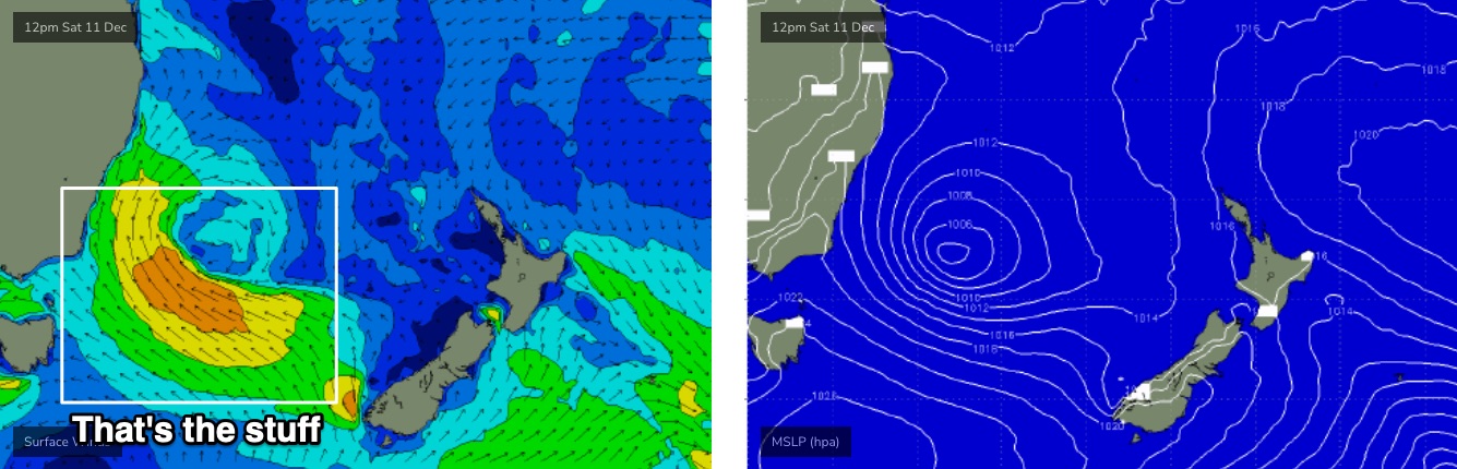
We’ll see a mix of swell trains from the SE (from today’s sideband energy off the initial stages of the trough) and S (from the developing southerly fetch). A tertiary, though eventually dominant S/SE swell will fill in on Sunday from another fetch firming up around the southern flank of the low on Saturday.
All in all we’re looking at 5-6ft+ sets at south facing beaches both days, but with Saturday afternoon showing a period of larger surf in the 6-8ft range. Exposed south swell magnets such as the Hunter should pick up the upper end of this size range all weekend. Expect much smaller surf at beaches not open to the south.
Fresh S/SW winds are expected on Saturday though early morning should see a general SW flow (even W/SW across a few regions such as the Northern Beaches). Winds will throttle back on Sunday though the diurnal directional trend should be similar.
Next week (Dec 13 onwards)
The Tasman Low will maintain strength through Sunday, meaning Monday’s on target for strong S/SE surf around the 5-6ft+ range at south facing beaches, easing to 4-5ft through the day, then abating further from about 3ft on Tuesday. Expect smaller options at beaches not completely exposed to the south.
Even better, light winds will maintain clean conditions under a weak pressure gradient. As such, we should see some great waves to kick start the working weekend.
The rest of the week looks pretty small.
In Wednesday’s forecast I discussed a potential small flukey NE cyclone swell, originating from Tropical Low 07U which will intensify into cyclone status in the Coral Sea on Saturday. However, the latest model runs have nudged its path a little to the north, which will now be sheltered (relative to NSW) by New Caledonia.
Furthermore, its latter passage through the north-eastern Tasman Sea (between New Cal and New Zealand) is expected to be too fast to generate any meaningful groundswell, so I’m not getting my hopes up from this source at the moment.
Model guidance does have some stray long period NE energy arriving later Mon/Tues from the early Coral Sea stages, before easing Wed, but at only 0.3m I doubt it’ll be visible above the pre-existing, easing SE swell.
So, make the most of early next week's easing S/SE swell!
Have a great weekend, see you Monday.
Comments
Hey Ben can u explain again What are the criteria to call it an ECL as opposed to tasman low? Is is something with the drop in pressure and “bombing” effect ??
Here's something Craig prepared earlier.
https://www.swellnet.com/news/swellnet-analysis/2015/04/20/when-east-coa...
Also, as per Craig's comments further down, the good Prof Ian Goodwin "proposes splitting it down further into 4 different categories" (five, as it turns out):
1) Easterly trough lows (ETL)
2) Southern secondary lows (SSL)
3) Inland troughs (IT)
4) Continental lows (CL)
5) Extratropical cyclones (XTC)
Cheers mate i remember reading that article a while ago always good to revisit it and know the technicalities to understand the proper scientific criteria
Had 2 cracking surfs today first time in a very long time.. beers sliding down quickly this arvo
Looks like north Sydney has much better conditions than south of the bridge to the illawarra. My local wasn't very inspiring this morning (Shellharbour area).