When is an east coast low not an East Coast Low?

 It's autumn, the time of year when east coast surfers stop looking to the northern swell window and wait for the south swells to kick in. There are a few different sources for south swells but some of the most exciting are low pressure systems that form in the Tasman Sea. When those 'onion ring' systems show on the synoptic map the term 'East Coast Low' is uttered by all and sundry, but when is it correct?
Sometimes the system in question sits closer to New Zealand's west coast than our east coast. So what actually is an East Coast Low (ECL)?
Each year – and especially during autumn and winter - many types of troughs, lows, and surface depressions form adjacent to our east coast, each providing different swell potential. The most significant of these swell-producing systems are Tropical Cyclones, Tasman Lows, and East Coast Lows.
Tropical Cyclones are easily classified; there are a set of atmospheric conditions and wind speeds agreed upon by the meteorological community. When a weather system meets those thresholds it becomes a Tropical Cyclone. The definition is fixed.
Tasman Low is a blanket term for any low pressure system that forms or travels through the Tasman Sea. Often Tasman Low and East Coast Low are used interchangeably, but this is incorrect as an ECL is a particular type of system that intensifies near the land/sea interface. ECL's have their own set of thresholds independent of Tasman Lows.
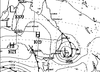
To begin with, an East Coast low has to form within 500 kilometres of the eastern Australian coastline. So those lows that sit near New Zealand sending long range SE swell fall outside the classification - they may as well be West Coast Lows. The other aspect of their positioning is that they must form between 25 and 40 degrees south. Also, an ECL must at some stage move parallel to the coastline.
The Bureau of Meteorology have some extra qualifiers for categorising an ECL; the system in question must exhibit gale-force winds along the coast, generate flooding rains, and create large prolonged storm swells. Again, those mid-Tasman low pressure systems fail to fit the bill.
Meteorologists determine East Coast Lows as systems that display the following:
- Forming within 500 kilometres of the coast.
- Moving parallel to the coast at one point of its life cycle.
- Destructive winds of at least gale-force strength.
- Widespread rainfall.
- Rough seas and heavy swell.
Each year only a few systems, if any, tick all the above boxes and are genuine East Coast Lows. The rest are correctly classified as Tasman Lows. It may seem a trivial matter, only of concern to meteorologists and academics, yet the distinction can determine how to chase swell.
 Once a system is labelled as an East Coast Low, expectations are heightened within the surfing community and everyone instantly thinks of pumping surf. Yet the people who score are those who work for it.
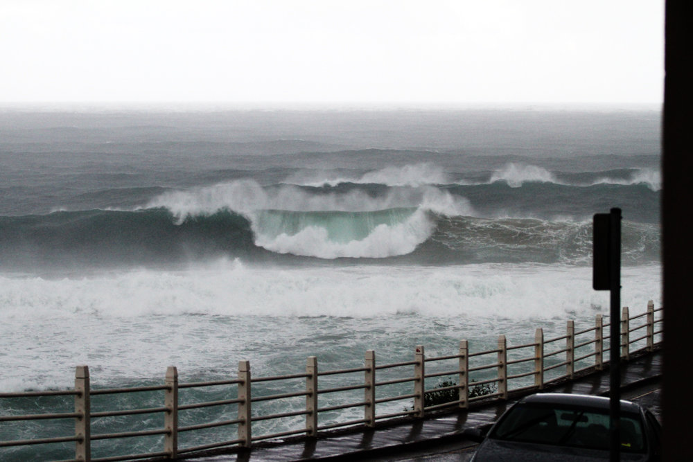
East Coast Lows often produce large waves as, by definition, they form in close proximity to the coast. Of course this also means there are the prerequisite gale-force winds but – and this is important - where you are in relation to the low's axis determines the direction they're blowing. Places to the south will have onshore winds from the east to south-east, but places to the north of the axis will have drier offshore winds from the west to south-west.
Keeping north of the lows axis, but not so far as to miss out on the swell is key to getting the best waves from these systems.
Many epic swells have originated from these intense and dynamic weather systems. The most memorable event being that of the Pasha Bulker, the coal ship that washed up onto Nobbys Beach, Newcastle in the winter of 2007.
Professor Ian Goodwin is one of Australia's leading researchers in coastal oceanography, marine climatology, and geology, and one of his current projects is a more exact classification system of closed circulation lows off the East Coast. Professor Goodwin proposes splitting it down further into 4 different categories. //CRAIG BROKENSHA and STU NETTLE
Note: An East Coast Low is currently forming in the western Tasman Sea, read up on the latest forecast notes here: Northern Beaches Forecast Notes
Northern Beaches WAMs
Comments
Great article Craig.
what about this one Craig?
ECL or no?
This one for sure!
Wattamolla gusting 65kts (hurricane force), rain totals between 40-50mm already and we've got a large swell event across the coast.
There's another east coast that benefits from these types of systems as well stretching from Flinders Island in the north to as far as Schouten Island in the south. While mainland Australia is waiting for the carnage to die down us Eskimos down south are reaping the rewards of a perfect 4 foot 12 second north east swell fanned by prevailing westerly winds . Life's tough in the shadow of a good ECL!!!!
And here we have a clear example of the pumping clean surf north of the East Coast Low currently sitting across Southern NSW, and then the large stormy waves along with poor weather in Sydney..
North of the ECL..
South of the ECL..
yep, she's a doozy.
Great article Craig, top ECL to base it on! The obs coming out of the system, esp the winds peaking out at Wattamolla for 30 plus hours straight are pretty incredible. There was one in July 2001 where similar winds sustained for as long at Montague Is, but they seem pretty rare. The sub tropical jet and the high sea temps also seem to be playing a role in keeping this one going.
Excellent article. I enjoy Swellnet as much for the writing (and in this case ongoing learning) as the photos and forecasts. Many Thanks Craig (Stu & Ben).
Thanks everyone, we talk a lot about certain storms/weather events and phenomena in the office all the time and it's good to be able to share it.
Yep, a big event for sure: second biggest Hsig in Sydney (8.1m vs 8.4m in 1997), longest period with Hsig over 6m (30hrs vs 24hrs in 1997), and the largest single wave ever recorded in NSW (14.9m)
Also the first major swell event in some time where the buoy comms have kept transmitting!
(sorry, had to add it in).
Looks like another ECL to form next weekend again off NSW coast, Aus, Euro and US models in pretty good agreement at this stage.
This one probably won't be classified as an ECL but more a Tasman Low.
Good to see though, these events are known to cluster as well. Ie when one ECL forms the likelihood of a second and third forming increases dramatically.
"Professor Goodwin proposes splitting it down further into 4 different categories. "
Which are...!
What were the buoy readings during that Syd - Hobart 1998 ..just curious ?
@ udo ,Have you ever read The Proving Ground ?
Soft, Bee Stung, Semi and Cat can't scratch .
Welly, that would be..
1) Easterly trough lows (ETL): Events that track mostly east of the Great Dividing Range and in a southerly direction.
2) Southern secondary lows (SSL): Events that track mostly over the ocean and in a northerly direction.
3) Inland troughs (IT): Events that evolve mostly over land, west of the Great Dividing Range and north of 30degS.
4) Continental lows (CL): Events that evolve mostly over land, west of the Great Dividing Range and south of 30degS.
There is a 5th mention as well..
5) Extratropical cyclones (XTC): Differentiation be- tween canonical ETL events and those that evolve from tropical cyclones based on storm track trajec- tories is problematic, as both storm types evolve in a similar region and follow similar tracks. However, the BOM maintains a database of all tropical cyclone occurrences and tracks from 1900 to present (avail- able online at www.bom.gov.au). Events that evolved from storm systems included in this database are classified as XTC.
"Factors evaluated by the classification al- gorithm are the following: storm-track latitude, whether the storm evolved mostly over the land or the sea, whether it tracked north or south, and its orientation to Australia’s main topographic divide (i.e., the Great Dividing Range)."
From this interesting paper Large-Scale Influences on the Evolution of Winter Subtropical Maritime Cyclones Affecting Australia’s East Coast
Be interesting to see how it develops, reckon it looks ECLish with deepening off southern Qld coast Friday morning, slowly tracking down the NSW coast Saturday-Sunday. Either way looks wet, windy with plenty of swell somewhere again.
On the 98 Hobart, I can't recall if MHL Eden buoy was in place at that time. Waves were recorded at Kingfish B platform of around Sig Wx 6-7m, Max Wx 11-12m, but this site is about 100 miles upwind of the worst affected area off Gabo where the fleet were hit, and where the East Australian Current was running against the sou'westerly storm seaway at 3-4 knots, a factor contributing to the big rogue waves that took a number of yachts out. Accounts from blokes in the race who I've sailed with over the years, plus reports from other yachts and heli crews in the enquiry that followed, were that 20-25m rogues were rumbling through fairly regularly. One yacht reckoned they got barrelled on one of them.
"A deep East Coast Low over the southeast Tasman Sea sets up a strong pulse of mid period SSE groundswell for Thursday under favourable W winds."
... says one surf website about the current synoptic situation.
It ain't an East Coast Low when it's sitting just off New Zealand's West Coast.
"EIL"
East Island Low, commonly referred to as "SFS" sheep fuckers system.
SFS ha ha classic.
Haha Gold
Now THIS was an East Coast Low!
48hr rain totals: 439mm at Tomerong, 390mm at Nowra, 336mm at Kiama.
why 500 kms? Is that just a figure they used or does it have some weather relation, like rain events, wind strengths back on coastline etc.
often wondered why it is not categorised like cyclones as they all have different strengths- what did the pressure drop to in the guts of this girl?
rain events like a cat 3 or 4 storm?
"An East Coast Low is about to deliver a glut of powerful surf to the Eastern Seaboard"... says a particular surf website about the current synoptic situation.
This is not an East Coast Low. In fact, it would be more accurate to call this upcoming system a 'West Coast Low', as it's going to be positioned closer to the West Coast of New Zealand than the East Coast of Australia.
As weather forecasters, it's our job to inform but also educate readers. As much as surfers get excited about terms such as 'East Coast Low' they're very particular systems, much the same way a cyclone is a weather system with particular characteristics.
See the above article for a description of the characteristics of an ECL.
I think you're still dirty that someone posted a chart on swellnet from another website :-)
that is in a gorgeous position.
The start to this year keeps getting better and better.
Craig, unbelievable.
Yesterday and today were the only virtually unsurfable days I can remember this year, at least swell wise. I say virtually as there were still plenty of punters out having a go both arvos, but I couldn't even raise the interest for a bodysurf.
And that will all be back to top gear on Friday, with me looking for hidey holes.
Thanks for clearing that up Ben. I was thinking, based on learnings from this here website and other reading, that this was not an ECL, but a Tasman low.
I've been sliding these perfect little banks at Manly on my 8ft singley, water is as warm as it gets, suns out and there's more swell coming, life is great!
Was the storm of the 98 Sydney to Hobart yacht race and ECL or tasman ?
The 98 Hobart storm I think was a 'cut off low' that formed in Bass Strait (the low centre was initially just off Wynyard on the NW Tas coast), and then intensified as it moved east through Bass Strait and eventually into the Tasman. Bass Strait Low? A storm that rips through the Strait from time to time and helps maintain its reputation.
Exciting couple of days of chart/buoy/obs watching with a significant Tasman Low undergoing development (not a 'large scale East Coast Low').
The BOM have - finally! - done an informative article on this topic ("So, when is a bad-weather-bringing low not an ECL?").
Relevant to much of this discussion is this description:
"If an intense low pressure system lies further from the coast than around 200 km, we usually call it an offshore (or Tasman) low."
http://media.bom.gov.au/social/blog/2140/know-your-lows-east-coast-lows-and-lookalikes
Ben, conditions look set up for an ECL with warm water and amcooler air, but not much on the charts, does the Long Wave Trough need to align up the East Coast to improve chances of an ECL now?
We need a few things to go right for an ECL to form. Firstly a pronounced node of the LWT will help as it's more likely to shed off an upper cold pool in the upper atmosphere which provides the catalyst for surface trough/low intensification. We also need the uppers to be fairly stationary so that the cold pool isn't swept off to the east quickly.
The current predictions for next week don't have the cold pool shedding off, so any kind of low looks unlikely.
Anyone here ever converse with Roger Badham re east coast weather
Lives near you Stu i think ?