Complex array of swells inbound across Southern NSW

Sydney, Hunter and Illawarra Surf Forecast by Ben Matson (issued Wednesday 29th July)
Best Days: Most days should have periods of great waves, though the weekend is the pick with light variable winds both days (Saturday for the size).
Recap: Tuesday offered easing E’ly and building S’ly swells in the 8ft range, with mainly gusty S/SW thru’ SW winds, though the Central Coast and Hunter saw an early period of W’ly winds at dawn. Size eased from both sources to 4-5ft this morning, and further to 3-4ft this afternoon, and early light W’ly winds created clean conditions ahead of a moderate afternoon southerly breeze.
This week (July 30 - 31)
There’s no shortage of swell on the way.
A modest S/SW fetch parallel to the Southern NSW coast will strengthen into Thursday as a new low forms in the central Tasman Sea - essentially the merging of the remnants of the previous Tasman Low (or ECL, I’m still not sure), and a southward-tracking tropical depression currently in the lower Coral Sea.
It’ll then be further reinforced with the arrival of a third system, a strong front pushing through the lower Tasman Sea, which will strengthen the new Tasman Low into quite a beast of a system, reaching a peak in intensify around Friday afternoon, before slowly dissipating into the weekend.
The low won’t be perfectly aimed for our region but its slow moving nature and close proximity will ensure a healthy spread of strong energy back into Southern NSW.
The upshot of this is a building combination of S’ly and S/SE swell through Thursday, with the S’ly swell easing into Friday but the S/SE energy continuing to build ahead of a peak in size on Saturday. Note, this is somewhat against model forecast, which estimates a Friday morning peak and then gradual decline.
Thursday’s size should build from 3ft (south facing beaches) in the morning to 3-5ft by the end of the day, and Friday’s likely to see a similar size range, slightly undersized early but closer to 4-5ft by the end of the day.
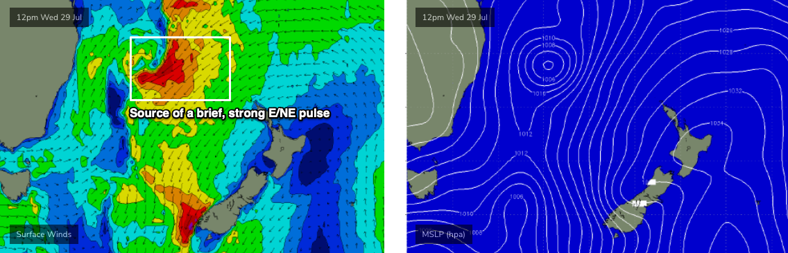
Also in the mix over the next few days will be an E/NE swell, generated by a broad fetch on the eastern flank of the approaching tropical depression/trough sliding down from the Coral Sea. Residual E/NE swell should manage 2-3ft sets on Thursday morning, but the inbound energy should be worth 3-5ft surf from Thursday afternoon through Friday.
In fact, a rapid intensification of this system sometime later today (see chart below) may generate a brief pulse of slightly bigger surf - an outside chance for a few 5-6ft sets at some reliable swell magnets - this is most likely to occur either very late Thursday or very early Friday (i.e. don’t be surprised if the wave buoys pick up an overnight peak).
As for conditions, Thursday morning’s temporary smaller size will see the cleanest surf overall under a light W’ly breeze, but redeveloping S’lies throughout the day will focus the best waves to sheltered southern ends. A lingering S/SW flow on Friday will ease back to moderate strengths, and many coasts should see morning W/SW winds but overall, though on the balance surf conditions regionally will be a few rungs below excellent.
This weekend (Aug 1 - 2)
The primary E/NE fetch responsible for the late Thurs/Fri pulse will push slightly outside of our swell window over the coming days, but there’ll be enough energy back in the South Pacific to ensure a small undercurrent of user-friendly E/NE swell through the weekend. Most beaches should pick up inconsistent 3ft sets from this source.
Much more dominant in the water on Saturday will be a peaking S/SE swell from the Tasman Low. South facing beaches should see 4-6ft sets through the morning, easing slowly into the afternoon and further into Sunday (say, 3-4ft early), however south swell magnets like the Hunter should pick up occasional bigger bombs north of 6ft to maybe 6-8ft early Saturday (trending down all weekend as well).
Local conditions look fantastic all weekend with light variable winds, so it’s well worth booking in some water time both days.
Next week (Aug 3 onwards)
The models have currently downgraded much of next week’s developments, stalling a broad cut-off low south of the continent (keeping it west of the Tasmanian divide) and also weakening another tropical depression north of New Zealand over the weekend. We’ll see fun, persistent E/NE swells through the first half of next week, somewhere in the 2-3ft range but no major size is expected.
Offshore winds will strengthen mid-week as the cut-off low west of Tasmania strengthens but it probably won’t be until next weekend that we see an associated southerly swell from this system as it migrates below the Tasman Sea.
More on this in Friday’s update.
Comments
Sounds very exciting Ben!
North or south for a trip?