Reasonable weekend of waves, reasonable long term prospects too

Sydney, Hunter and Illawarra Surf Forecast by Ben Matson (issued Friday 21st February)
Best Days: Sat/Sun: fun S'ly swell, OK morning winds. Tues/Wed: early light winds, flukey long range S'ly swell. Next Sat/Sun: stronger S'ly groundswell.
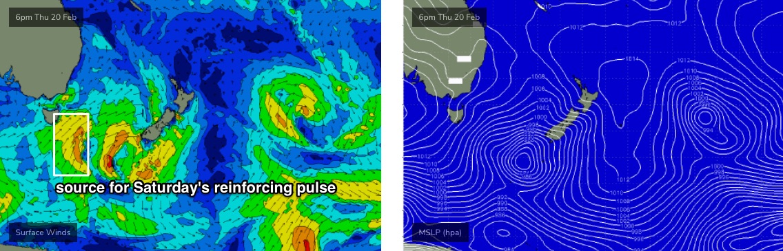
Recap: Building S’ly swells on Thursday came pretty close to expectations by the afternoon, with 4-5ft+ surf reported at many south facing beaches and some bigger bombs south of Sydney. Early light winds gave way to moderate S/SE breezes from late morning onwards. Size has eased today from 4ft at south facing beaches, and we’ve seen light winds for much of the day in most areas.
This weekend (Feb 22 - 23)
We’ve got a few OK waves in store for the weekend but it won’t be anything amazing.
A developing high pressure system in the Tasman Sea will push a weak ridge into the coast over the weekend. This will steer the winds to the east on Saturday, and the north-east on Sunday. Early morning should see periods of light variable winds.
As for surf, today’s S’ly swell is on the way out but we’ve got a reinforcing pulse due on Saturday, courtesy of a strong but fast moving front below Tasmania today (see below). This should rebuild size up to 3-4ft throughout the day (possibly some bigger sets across the Hunter), but beaches not open to the south will be smaller thanks to the swell direction.
Wave heights will then ease through Sunday. Early morning should maintain 2-3ft+ sets at south facing beaches (bigger across the Hunter) ahead of the abating trend, but with much smaller surf elsewhere.
Also in the water over the weekend will be a small undercurrent of distant, diffracted E/NE swell from a sub-tropical low positioned east of New Zealand earlier this week. Its poor location inside the NZ swell shadow means we won’t see much size or consistency, but the odd 2ft set may pop up from time to time (most likely Saturday, easing Sunday).
Next week (Feb 24 onwards)
A stationary ridge across the Northern Tasman Sea will supply minor E/NE swells for Southern NSW for much of next week, mainly through the first half with very inconsistent, slow 1-2ft sets at exposed beaches.
Later Monday, Tuesday and Wednesday should also see some stray sets at south swell magnets from an active though poorly aligned storm track below the continent over the coming days. The only reason I’m expecting any potential surf is because most of the fetch associated with this pattern is expected to remain below 50S, which is just inside our flukey long range south swell window. Most beaches won’t see much from this pattern but reliable south swell magnets could pick up occasional 2-3ft waves every fifteen or twenty minutes. Keep your expectations low and you may be pleasantly surprised if there are some fun options across your favourite south swell magnet.
Conditions should be OK through this period, with generally light winds on hand, though late Monday and late Tuesday could see local NE breezes creating surface issues (the mornings should be OK). Wednesday afternoon has a gusty S’ly change on the cards, though early morning should see favourably light winds.
Wednesday’s change will have a trailing south swell (for Thursday) but a much more vigorous Southern Ocean front positioned behind this has better quality southerly groundswell prospects, probably late Friday or more likely Saturday and then holding into Sunday. It’s still quite some time away though, so we’ll take a closer look on Monday.
Also, the models are suggesting a tropical low will drop south from a position near Samoa next week, and take up residence well east from New Zealand mid-late week, which should set up another interesting diffracted E/NE groundswell for the early to middle part of the following week (say, around March 3/4). This will probably be better positioned for SE Qld and Far Northern NSW but I’ll have more details on its potential next week.
Plus, there's a good chance we'll see local troughiness in the western Tasman Sea around this time generate a sizeable, punchy local swell of some description too. So there's plenty to look forward to in the longer term outlook.
Have a great weekend!
Comments
We are blessed!