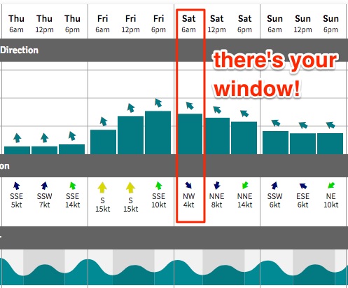
Saturday morning is the pick of the forecast period

Sydney, Hunter and Illawarra Surf Forecast by Ben Matson (issued Wednesday 25th October)
Best Days: Sat: early window of light winds and a peaky, easing SE swell.
Recap: Small, easing S’ly swell through Tuesday have bottomed right out today. Moderate N/NW tending NE winds on Tuesday swing light offshore early this morning before swinging E/NE and then NE again this afternoon.
This week (Oct 24 - Oct 27)
No changes for the rest of the week.
A developing northern flow off the Northern NSW coast - in response to an evolving surface-trough-cum-weak-Tasman-Low off the Southern NSW coast - won’t be well positioned to generate any short range N’ly swell for us. If anything, the fetch will be N/NW, aimed more towards Southern New Zealand.
As such, I’m not expecting any surf from this fetch, maybe a few small waves at reliable NE swell magnets later Thursday and into Friday but nothing to get excited about.
Variable winds Thursday morning will pick up from the SE during the day as the trough intensifies and moves offshore, but it’ll kick in too late to be of any benefit to our surf potential. In fact north from Sydney through the Hunter region could remain variable for most of the daylight hours, as it’ll be positioned right within the axis of the trough.
Winds will then swing more S/SE through Friday as the low broadens across the Tasman Sea, probably remaining at strength so surf conditions will remain below average right across Southern NSW. We will see a short range swell kick up size to 3ft+ throughout the day but I really can’t see there being much quality owing to the fresh onshore airstream. Southern corners may have a small cleaner wave but it’s not worth getting excited about.
This weekend (Oct 23 - Oct 24)
Saturday morning is shaping up to be potentially alright for surfers.
We’re looking at a peak in short range SE swell overnight, and a slow easing trend through Saturday. But, the Tasman Low will be weakening and moving east by this time so we’ll be back to a light variable tending NW airstream early on, ahead of a freshening N’ly breeze during the day. Open beaches should see some peaky 3ft sets. Surf early for the biggest and cleanest waves.
A weak trough will cross the coast overnight Saturday, briefly swinging winds to the south before a variable pattern returns through Sunday morning ahead of another afternoon northerly. However surf size will be back to 1-2ft at exposed beaches so don’t expect a lot of size or strength in the surf zone.
Next week (Oct 25 onwards)
Freshening N’ly winds early Monday will precede a late, gusty S’ly change and a rapid increase in short range swell after lunch as a cold front moves into the southern Tasman Sea. It’s hard to tell if it’ll kick in before close of business, but it’s a moot point anyway as the accompanying winds will render most locations very choppy.
Persistent southerlies in the wake of this system - possibly the result of a small Tasman Low forming east of Sydney - will maintain moderate sized but average quality surf through Tuesday. The system may dominate the western Tasman Sea's synoptics through the middle of the week, but we need a few more days to firm up the guidance. Stay tuned to Friday’s update for more. In any case I can't see there being quality surf to drop tools around.
Of much more interest is a slow moving high modelled east of New Zealand from next Sunday onwards, which is expected to broaden a decent E’ly fetch on its northern flank. This is shaping up to develop into a decent source of sustained E/NE swell through the middle to latter part of next week and the following weekend, though it’s still too early to put a size range on it (early indications suggest a peak in the 3-4ft range entered around next Saturday, give or take).
More on this in Friday’s update.
Comments
Ho Hum!