Mixed swells, average conditions for Southern NSW

Sydney, Hunter and Illawarra Surf Forecast by Ben Matson (issued Monday 12th December)
Sign up to Swellnet’s newsletter and receive the Sydney/Hunter/Illawarra Forecaster Notes and latest news sent directly to your inbox. Upon signup you'll also enter the draw to win a surf trip to P-Pass for you and a mate. It doesn’t get much easier so click HERE to sign up now.
Best Days: Tues/Wed: small peaky NE swell with light winds early morning. Fri: chance for a period of light winds (mainly Hunter) with a mix of NE windswell and small S'ly groundswell. Sat: small peaky mix of swells with early light winds.
Recap: Strong southerly swell occupied Saturday with dawn revealing 4-5ft sets at south facing beaches and 6ft bombs across the Hunter, ahead of a slight increase through mid-late morning. Surf size eased a little into the afternoon and further into Sunday. Winds were light and variable Saturday morning before tending moderate NE; Sunday saw NE winds all day, light early morning then moderate to fresh in the afternoon. Today we’ve seen a small mix of NE windswell and easing S’ly swell around 2ft+ in Sydney and 2-3ft across the Hunter, with moderate to fresh NE winds in general (lighter earlier).
This week (Dec 13th - 16th)
Only small surf is expected for the next few days.
A minor S’ly swell generated by a poorly aligned front in the Southern Ocean over the weekend is expected through Tuesday, and should maintain 1-2ft sets at south facing beaches.
Freshening NE winds off the coast this afternoon should kick up a small NE windswell for Tuesday morning; no great size or strength is expected, set waves should hold somewhere between 2ft and maybe 2-3ft at reliable swell magnets (if we’re super lucky). Expect smaller surf elsewhere.
Conditions are looking workable early Tuesday morning with light to moderate N/NW winds; we will see a freshening N/NE trend develop from mid-late morning onwards, but the early surf should offer reasonable conditions. Expect a few wobbles through the lineup though.
This NE thru’ N/NE fetch anchored off the Mid North Coast will ebb and pulse through Tuesday, but a trough moving up the coast will disrupt the flow into the early hours of Wednesday. So we should see another pulse of NE swell into Wednesday morning though wave heights will trend down throughout the day from the early morning peak, again somewhere between 2ft and maybe 2-3ft at NE swell magnets (and smaller elsewhere, as the minor S’ly swell form Tuesday will be all gone).
The trough is not due into Sydney until mid-late afternoon (earlier on the South Coast) but ahead of it we’ll see moderate NW winds. So conditions should be pretty clean at most beaches. Just keep your expectations low for this NE swell as its source is a little flukey.
The coastal trough is expected to stay off the lower Mid North Coast early Thursday, and as a consequence most of Southern NSW will be under the influence of a fresh SE breeze for most of the day. These winds will whip up a low quality SE windswell for the coast but with the onshores it won’t be worth much effort.
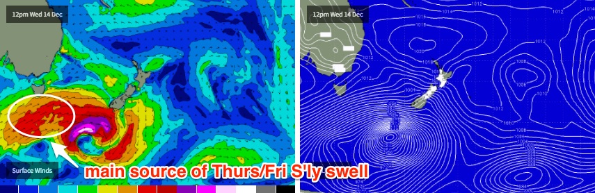
It’s unfortunate that this fetch will remain anchored across the coast during the day as a small, long period S’ly swell is expected to push up around the same time, generated by an intense low and secondary front tracking under Tasmania early Wednesday morning. Although the low will display storm force winds, most of the fetch will be just outside our swell window (and quite zonal in structure) which means we’ll see only a small percentage of energy glance the coast.
In fact, despite wind strengths associated with the secondary front being weaker, they’ll be slightly better aligned in our swell window (see image below) and will contribute more useful groundswell.
This series of south swell will build throughout Thursday (note: may not be in the water at dawn), holding into Friday with 2-3ft sets at south facing beaches and a few bigger 4ft bombs across the Hunter. The models aren’t picking up these south swells very well but it’s a moot point anyway with the average local wind forecast.
On Friday, a new trough will extend southwards along the Southern NSW coast, swinging the local fetch around to the east then north-east. There’s a chance for a region of light variable winds - more so across northern regions (i.e. Hunter Coast) than anywhere else - and the local fetch will also generate some NE windswell through the afternoon, though more so across the South and Far South Coasts (as winds are expected to be stronger here).
Anyway, there’ll certainly be waves to finish the week just without any major quality.
This weekend (Dec 17th - 18th)
We’ve got a complex weekend of waves ahead.
The coastal trough trough developing along the coast on Friday is expected to be replaced with a fresh southerly change sometime later Saturday (earlier on the South Coast). Winds will be variable ahead of it so conditions should be clean for at least the first half of the day.
As for surf, there’s a few sources.
A fresh E’ly fetch around the southern flank of Friday's trough should kick up a decent short range swell but I suspect it’ll only affect the Far South and South Coasts up to about Wollongong (2-3ft+ sets early) with smaller surf north of here. Size will ease during the day.
There’ll also be a small NE windswell across remaining coasts in the 2ft range. And possibly some leftover S/SE swell at south swell magnets in the 2ft+ range, originating from the parent fetch related to Friday’s southerly groundswell as it tracks near New Zealand later Thursday.
All of these sources will ease on Sunday, to be replaced by a short range S’ly windswell trailing Saturday’s change. This system isn’t very well consolidated on the current forecast charts so there’s an outside chance for an update over the coming days. Let’s see how this is looking on Wednesday. But right now local conditions look like they’ll be a little second hand under a moderate to fresh S'ly breeze.
Next week (Dec 19th onwards)
I'm still tracking a possible tropical system way out near Fiji throughout the latter part of the model forecast. The current positives are that it’s slow moving, the negatives are that a stubborn (modelled) high pressure system to the SW is focusing the fetch up into the Coral Sea, away from Southern NSW. But there is certainly some potential for the long term period.