Great south swell for Thurs; flukey south swell for the weekend; E/NE possibilities for next week

Sydney, Hunter and Illawarra Surf Forecast by Ben Matson (issued Wednesday 16th October)
Sign up to Swellnet’s newsletter and receive the Sydney/Hunter/Illawarra Forecaster Notes and latest news sent directly to your inbox. Upon sign up you'll also enter the draw to win a surf trip to P-Pass for you and a mate. It doesn’t get much easier so click HERE to sign up now.
Best Days: Thurs: solid renewal of S'ly swell with good winds in the morning. Fri: rapidly easing S'ly swell with good winds early. Sun: chance for an inconsistent S'ly swell at south swell magnets. Wed onwards: chance for an E/NE swell.
Recap: Tuesday delivered a good fun south swell with early 4-5ft+ sets across south facing beaches (bigger across the Hunter) easing throughout the day. Winds swung offshore through the morning, slowly cleaning up the overnight bumps. Today we’ve seen fun leftover S’ly swell around the 3ft mark at south facing beaches with early offshore winds tending moderate S’ly then SE during the day.
This week (Nov 17th - 18th)
Now that the first of two expected south swells has been and gone, we can now focus on the second event.
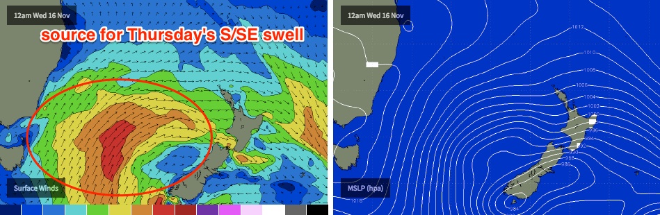
There are a couple of positives and negatives associated with this next system but on the whole I think it’s going to deliver some very good waves.
The positives are that the responsible front is very broad and robust, travelling from polar latitudes through the central and eastern Tasman Sea, and wind strengths were reasonably strong within the core fetch. This should result in decent swell periods (Tp of 13-14 sec, Tsig of 10-11 sec), and the eastern position of the fetch should favour a slightly wider range of locations owing to a little more east (of south) in the swell direction.
However, the fetch wasn’t aimed very well through our swell window, which means the swell will glance the coast, resulting in less consistent set waves. And it won't be quite as big as if the fetch had been aimed up through our immediate south swell window. However winds will be light for Thursday morning - around the time the swell should be reaching a peak across Sydney/Hunter/Illawarra beaches - so conditions will be clean.
South facing beaches should pick up inconsistent 4-5ft sets from this source, and offshore bombies and the Northern Hunter are likely to see occasional bigger sets pushing north of 6ft at times.
However, beaches not directly open to the south will be much smaller (3ft) and protected southern corners will be very small indeed.
Winds will swing to a NE sea breeze during the afternoon and surf size is likely to tail off after lunch so make the most of the morning session.
A more pronounced drop will then occur on Friday. Some exposed south facing beaches - mainly across the Hunter - may see early 2-3ft sets but elsewhere it’ll be smaller, and surf size will ease in size throughout the day as early light NW winds tend NE and freshen. So, aim for an early surf at your favourite south swell magnet and get in early for the best waves.
This weekend (Nov 19th - 20th)
A weak trough pattern is expected across the Southern NSW coast this weekend.
No major strength is expected in the wind department but we’re also not expecting much in the way of new swell on Saturday, mainly small residual energy from Thursday’s S/SE swell and a trickle of NE windswell.
There is one interesting source of new groundswell that is modelled to move up the Southern NSW coast late Saturday and potentially produce some fun waves at south facing beaches for Sunday. An intense mid-latitude low SW of Tasmania on Thursday is expected to slide into our south swell window by Friday, though the primary fetches will be aimed well and truly away from our coast.
However the sheer size and strength of this system could override some of the directional deficiencies. Unfortunately, the latest model guidance has slightly altered the alignment of this low (less favourably than Monday's models suggested) though it hasn’t really weakened it. As such I am revising surf size down a touch from earlier estimates to very inconsistent 2-3ft+ sets at south facing beaches throughout Sunday, maybe appearing later Saturday across the South Coast. Confidence is never high on the timing of these swells, let alone the project size (as the models are not confident in much size, just half a metre at sixteen seconds). Gut feel suggests we'll see the biggest waves after lunch.
That being said, the Hunter often does a very good job at raking in these swells and we could see some bigger waves here throughout Sunday; 3-5ft sets for the afternoon session wouldn’t surprise me at all. Though, this is a low confidence event so keep your expectations in check. Winds should be light and variable throughout the day with afternoon sea breezes.
Next week (Nov 21st onwards)
The low responsible for Sunday’s groundswell will travel only slowly through our far southern swell window, which suggests an extension of Sunday’s waves - whatever eventuates - into Monday, before easing slowly into Tuesday as smaller S/SE swells from the backside of the eastward traversing system makes landfall.
Otherwise, I’m still keeping a close eye on a deepening tropical depression across the Coral Sea later this week and into the weekend.
Model guidance is now suggesting the axis of this system will push just south of Byron latitudes around Monday evening or Tuesday, and this - if it eventuates - is a significant synoptic benchmark as it’ll open up the prospect for a direct E/NE or NE swell for Southern NSW mid-late next week (normally, these kinds of patterns will often remain anchored across the lower Coral Sea, meaning Southern NSW receives small sideband energy with little size or strength).
However, there are a multitude of possible scenarios that could swing for or against the prospects of good waves from this system, and it’s a long time away still so we really need a few more days to firm up the model output. This swell window is a great surf producer for Southern NSW so I’ll be keeping a very close eye on things through into Friday’s update - see you then.
Comments
Umm some very unhappy surfers at Newy tday....what the fuck are the council doing to the foreshore
hoy666 insta
"This swell window is a great surf producer for Southern NSW so I’ll be keeping a very close eye on things through into Friday’s update - see you then."
Unless you're in the swell shadow of Jervis. Sticks out a fair way.
Surely you can rack up some highway miles? I wouldn't have thought the Jervis shadow was that big?
No, not that big. Just impacts the area i call home away from home.
Looks like today's swell could be lagging behind a little.. periods are now just starting to increase.
A few stronger sets now.
Wind is into it
Just had a surf at Bondi... can't believe it but I think it was actually my first time in the water there. Lived up to its awesome reputation too.
Swell was very inconsistent, slightly bigger than 4ft on the sets but not quite 5ft. A little lumpy too.
And the bloody seaweed! Very annoying.
ben, you really put in the effort in to make sure your expectations were met at bondi -- turning up in the afternoon when the winds are onshore and when it's over three feet, despite bondi being well known as a beach that doesn't handle over three feet.
were you surprised to find that the only people out in such conditions were clueless blow-ins?