Great weekend of SE swell; strong S'ly swell mid-late next week

Sydney, Hunter and Illawarra Surf Forecast by Ben Matson (issued Friday 8th July)
Best Days: Sat/Sun: plenty of strong SE swell and light winds. Sunday the pick, esp with the late pulse of sizeable E/SE swell. Mon: freshening NW winds and strong, but rapidly easing E/SE swell. Wed: late kick in new S'ly swell. Thurs/Fri: strong S'ly swell across all coasts.
Recap:
Large, windy S’ly tending S/SE swells with gusty S’ly winds Thursday, tending SW in the afternoon before moderating into Friday. Set waves have managed around 6ft+ at exposed beaches with a slow easing trend evident throughout today. Many regions saw an early period of light W/SW winds this morning, mainly north of the harbour and up into the Hunter region.
This weekend (Saturday 9th - Sunday 10th):
The weekend’s looking really good for surfing.
We’ve got a couple of sources of energy at play. The short range swell of the last few days will ease, but a strong SE fetch developed in the southern Tasman on Thursday and this is generating a fresh round of SE swell due later today and into Saturday.
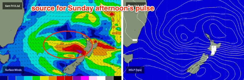
In fact, right now we’re also seeing a new E’ly fetch develop west of Cook Strait (the body of water separating New Zealand’s North and South Islands), and this is setting up two seperate pulses of E/SE swell, which will arrive overnight Saturday and then again late Sunday.
Comparing the various fetches, and they’re all uniquely different in core strength, alignment and distance from the coast, but they should produce similar sized surf across the broader Southern NSW region.
The strongest fetch of the lot will develop west of Cook Strait later today and despite the slightly larger travel distance, the extra oomph in the surface wind field should result in a slightly higher peak in surf size compared to the others, thanks to the larger wavelength (or swell period).
Ball park size range all weekend will hover between 4ft and 6ft at exposed beaches and reefs, but it will ebb and flow as we cycle between the various pulses. The likely trend on Saturday should kick off reasonably strong (i.e. occasional 4-6ft sets at open beaches, mainly those south facing) before easing back to 3-5ft during the day.
Sunday’s first new swell should rebuild back to 3-5ft at open beaches early in the morning, ahead of an afternoon arrival of stronger E/SE swell in the 5-6ft range (timing looks to be early-mid afternoon at this stage). In any case, the trend will be upwards all day on Sunday.
As for local conditions, both days look pretty good with mainly light variable winds, though Sunday gets the nod as Saturday’s likely to have a few lingering surface wobbles from today’s southerly flow. It’ll improve during the day but Sunday should provide great conditions all day.
Next week (Monday 11th onward):
Sunday afternoon’s pulse is expected to persist into early Monday morning but will trend steadily downwards throughout the day.
Strengthening pre-frontal NW winds will maintain clean, if somewhat blustery conditions about the coast so get in early for the most size: early 4-6ft sets are possible at exposed spots around dawn, but it’ll trend downwards within the first few hours of the day, and will probably be down to 2-3ft by the end of the day.
Tuesday will then bottom out with very small residual E’ly swell in the 2ft range at open beaches (becoming smaller as the day wears on), accompanied by strong to gale force NW tending W/NW winds.
Late afternoon may see a late arrival of new long-range E/NE swell, originating from the remnants of the low responsible for the current/weekend swell, as it pushes north of New Zealand on Sunday and re-intensifies. However it’ll be aimed well and truly away from our swell window so we’ll be seeing minor sideband energy at best, with occasional 1-2ft sets from late Tuesday through Wednesday.
The next major system for Southern NSW surfers will be associated with a powerful cold outbreak pushing across the SE corner of the country early next week (related to Monday’s gusty NW winds).
Initially, the fetch existing eastern Bass Strait - our funkiest south swell window - will be very west in direction. We need at least a smidge of south in the fetch before our south swell possibilities start to open up, and right now it doesn’t look like that will happen until the early hours of Wednesday morning.
Therefore, the next likely kick in south swell (in Sydney et al) will probably be around Wednesday afternoon at the earliest. The South Coast will see an earlier arrival though it’ll be at the mercy of the ‘axis of refraction’; the position on the coast whereby the south swell will start to feel the coast (this could be as far north as the Illawarra region). In short: locations further north are on track for more size from this particular phase of the storm than southern locations.
At this stage I’ll hedge an early guesstimate for late afternoon 3ft+ sets in Sydney on Wednesday, reaching 3-5ft across the Hunter coast in the few hours before dark. Expect tiny conditions prior to then.
As the associated cold front rounds the Tasmanian corner and tracks through the lower Tasman Sea, it’ll generate a proper southerly groundswell and this will be our primary swell source for the rest of the week as a series of strong secondary fronts push up from polar latitudes. At this stage Thursday and Friday are both on track for strong southerly energy somewhere in the 6ft range at south facing beaches (up towards 8ft in the Hunter), though we’ll fine tune the specifics on Monday.
Looking further beyond that, and it appears this strong southerly episode will then ease into next weekend, with abating wave heights but clean conditions under a broad ridge of high pressure.
So - plenty of surf for the foreseeable future!
Comments
So many swells in the forecast period.. this is certainly shaping up as a very active winter of NSW waves.
Well there was plenty of swell today but I really couldn't see much quality. I watched Mid Steyne for 20 minutes this morning with a stack of people out and didn't see anyone get a decent wave. Most other beaches were marginally surfable but no fun. It might have been better at the other end of the NB but the odds weren't good enough to make me drive there.
How's this barrel at Shark Island a few moments ago?
Live: https://www.swellnet.com/surfcams/shark-island
Shark Island on the pump again this morning. Not a soul in the water either.
https://www.swellnet.com/surfcams/shark-island
Strong lines at Bondi too.
As per the forecaster notes, this should be the first of two new SE thru' E/SE pulses; the second is expected this afternoon and should be a little bigger.
Still no-one out at the Island!