Clean conditions and easing S'ly swell to end the week

Sydney, Hunter and Illawarra Surf Forecast by Guy Dixon (issued Wednesday 25th May)
Best Days: Thursday and Friday.
Recap:
Good quality mid-range southerly swell graced our shores on Tuesday, providing options in the 3-5ft across south facing beaches of the Illawarra and Sydney coasts, more so up to 6ft along the Hunter. Today, stronger, longer range energy filled in, providing strong 6ft+ sets across south facing beaches, up to 8ft across the Hunter and even larger at exposed reefs and bombies.
Persistent offshore breezes have kept conditions clean and workable for the majority of this swell event, with plenty of great options on offer.
This week (Thursday 26th - Friday 27th) and weekend (Saturday 28th - Sunday 29th):
Following today’s strong pulse of southerly groundswell, conditions will ease across the NSW coast. South facing beaches should fade from the 3-5ft mark on Thursday, with the Hunter continuing to accentuate the energy, easing from the 4-6ft range.
The next significant swell generating system should develop on Thursday night in the form of a small, cut-off low just off the far South Coast of NSW, near Eden. The western flank of this low looks to steer south/southwesterly fetches of 35-45kts up the coast, driving further offshore throughout Friday.
This small but intense and close range system should whip up a southerly windswell at exposed south facing beaches, perhaps a touch larger across the Hunter, with the only limiting factor being the worsening alignment of the main fetches as it moves further into the Tasman sea.
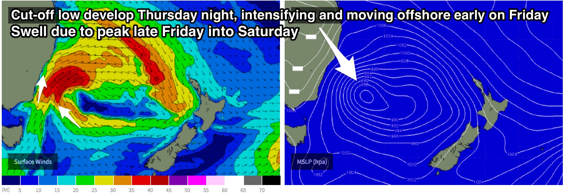
This swell is likely build to around 3ft late on Friday, before peaking during the overnight hours and easing from a similar size range on Saturday. Weak fetches on the southern quadrants of this low also have the potential to add a small amount of southeasterly energy to the mix, but the size will likely be negligible. Otherwise, background energy is likely to be the only source of swell on Sunday, with options easing from the 2ft range.
The remainder of the week and weekend should offer generally clean conditions, with Thursday seeing north/northwesterly breezes tend northwesterly and persist into the afternoon, while Friday is likely to be under a gusty west/southwesterly airflow.
Saturday can expect breezes to swing from northwesterly to southwesterly, more so west/southwesterly to westerly on Sunday.
Next week (Monday 30th onward):
The prospects for decent systems in the days following aren’t as good as previously anticipated. In Monday’s notes we were monitoring a small fetch which was expected to anchor itself off Stewart Island, the far southern tip of New Zealand, but models have moved away from this idea.
East/southeasterly fetches along the southern quadrants of a low positioned to the east of New Zealand’s South Island on Sunday afternoon have improving alignment to the NSW coast, but are still being hindered by the swell shadow of our trans-Tasman neighbours.
The only other system of interest comes in the form of a gusty, local southerly component airflow moving up the NSW coast. Southwesterly breezes look to tend more south/southwesterly and increase for a brief period of time on Sunday night before pushing offshore. A small, short range southerly windswell should provide options in the 2ft+ across south facing beaches on Monday morning, perhaps a touch bigger across the Hunter.
In terms of quality, options will be limited to the morning on Monday as breezes prevail from the southwest. As the afternoon wears on, winds look to tend southerly, so the exposed beaches that are offering the most size will likely lose quality.
Background energy generated by poorly aligned and poorly structured fetches should otherwise maintain small peaks across south facing beaches in the days following, ebbing and pulsing around the 2ft mark on Tuesday and Wednesday, smaller at less exposed spots.
Comments
biggest its been in years this morning (whilst clean).
Yep, biggest swell for a long time, at least on the Illawarra.
Barrack Point around lunch (click fullscreen to see properly):
Coal Coast early this morning (Photo Clarrie Bouma):
Right click and open image in new tab to view at full size (it's worth it!)
Merries Reefs, Kurnell (Photo Owen Rennie/Driftwood Cinema):
Vooeys?
Nah, 4th Bommie.
Farrrrrrk - you sure you didn't get the photos mixed up from the recent WA swell?! That things nuts. Anyone have a dig?
Saw a couple of legit 8 footers off Ulladulla (I wore them on the head!) Today caught a lot of the crew undergunned biggest in a long time yewwww
it was nice to be out in some clean size
didn't hit the NB too hard but had some decent size for a south swell, and stunet that things a fucken romper!!
Wow!
Smaller today but super clean. Still plenty of corduroy at Bondi.
Any banks though?
Guy what size should we expected from south facing beaches tomorrow at dawn? thanks
No major sign of new swell across the coast at the moment - looks around 2ft+ at Bondi.
But the swell increase can't be too far off - check the RapidScat images from earlier this morning - that's an insane 50-60kt fetch off the Far South Coast. We're likely to see a large, rapid increase in south swell later today (earlier on the South Coast).
Looks closer to 3ft now at Bondi. Still very inconsistent though.