Building E'ly swell with a solid S'ly pulse due Monday

Sydney, Hunter and Illawarra Surf Forecast by Guy Dixon (issued Friday 15th April)
Best Days: Early each morning, protected southern corners on Monday.
Recap:
We woke to showery conditions on Thursday morning, with small, residual southerly energy breaking across south facing beaches in the 2ft range, much smaller at open beaches. Conditions remained clean during the morning under a light northwesterly breeze, before tending light and variable preceding a northeasterly seabreeze.
Today, we are picking up a mix of easterly and southerly energy in the 2ft range. Conditions were clean earlier, but are slowly deteriorating as a light seabreeze develops.
This weekend (Saturday 16th - Sunday 17th):
A near stationary southeasterly fetch steered by a Tasman ridge has been lingering off the North Island of New Zealand over the past couple of days and is due to persist into the weekend while tending more east/southeasterly with slight intensifications.
The easterly energy that is currently breaking across the open beaches is as a result of this system and is due to build as the alignment and intensity increases. Saturday should see sets build to around 2-3ft, further on Sunday afternoon to around 3ft.
Meanwhile, a fairly ordinary southerly groundswell is also due to fill in late this afternoon, before peaking on Saturday morning, providing inconsistent sets in the 2ft+ range at the more exposed swell magnets.
The inconsistency of this swell is primarily due to the distant nature of the original system which developed over the southern Indian Ocean, southwest of WA earlier this week. As the swell front migrates across the Bight, the longer period forerunners will travel faster than the shorter period trailing energy, with the size being in this back bracker, hours behind the fore-runners and super inconsistent.
Residual energy should fade from the 1-2ft off the back off this distant pulse on Sunday, before a better south swell fills in early next week.
Northwesterly breezes are on the cards for Saturday morning, giving way to a northeasterly seabreeze later in the morning. A southerly change will then move through, becoming well established by Sunday morning. Protected southern corners of the open beaches should be offering a few workable options as breezes swing south/southwesterly at times.
Next week (Monday 18th onward):
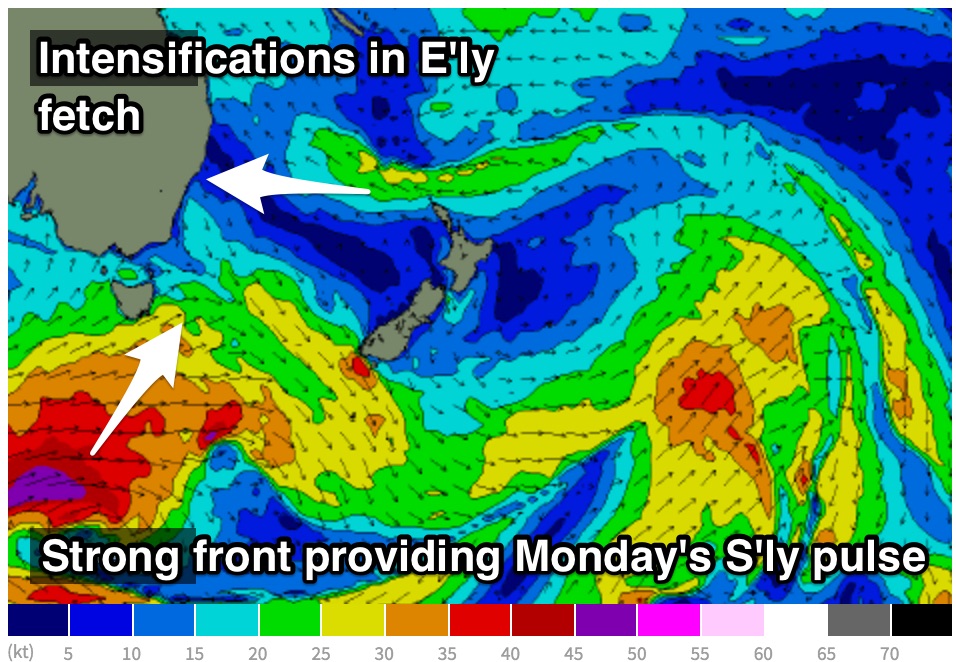 A healthy frontal progression is due to enter the far southern swell window later this afternoon and evening with strong southwesterly core fetches moving in a captured direction overnight and into Saturday.
In addition, broader, weaker fetches across the northern extension of this system should also provide a decent amount of energy. To make matters more complex, a local south/southeasterly wind swell looks to develop throughout Sunday associated with a change the previous day - so in essence, we have three swells generated by one large scale system to decypher.
Short range south/southeasterly energy should build throughout Sunday to around 2ft, but more so on Monday to around 2-3ft with a slight intensification and northward motion the night before.
The long-period groundswell energy from the Southern Ocean frontal progression should peak also on Monday morning with sets breaking in the 3-5ft range across south facing beaches.
Meanwhile, continued easterly activity over the Tasman during the weekend should maintain around 2-3ft of trade-swell across the open beaches.
Finding a clean wave is looking tricky, with a southerly breeze tending more south/southeasterly later. South of Sydney, there is the chance of an early southwesterly breeze, but either way, open beaches will be cleaner but smaller.
Following a brief hiatus with the passage of a front, a strong ridge looks to rebuild over the Tasman causing an easterly fetch to set up once again. Easterly swell should build back to around the 2-3ft range by late on Tuesday, potentially increasing on Wednesday and Thursday as fetches intensify as some models suggest a low to develop.
At this stage, this scenario remains shaky.
Tuesday and the days following should see an early southwesterly breeze, tending onshore later.
More detail next week.
Comments
South swell magnets are easily 5ft + with bombies also breaking. Shame about the wind